



In-depth guide · CampingSpirit
From Andria via Castel del Monte, the Alta Murgia plateau, Altamura and Gravina into the Valle d’Itria, to the conical roofs of Alberobello and Martina Franca and on to the cliffs of Polignano a Mare: around 375 kilometres through the interior of Apulia, where the length of your vehicle and the time of day matter more than the distance.
The spirit of the route
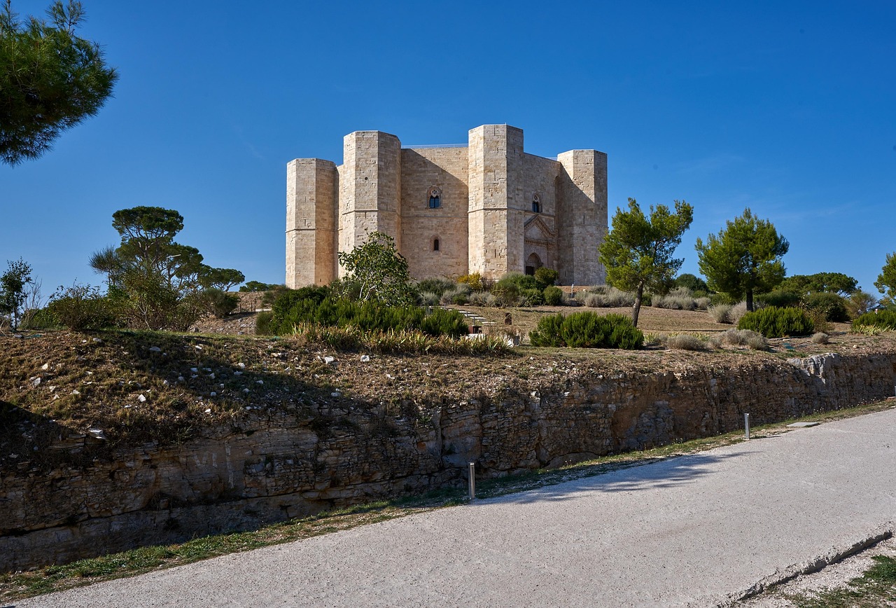
If you only know Apulia from the coast, you are missing its backbone. Beyond Andria the land climbs onto the Murgia: white and ochre limestone, kilometres of dry-stone walls, scattered holm oaks, flocks of sheep and the low stone huts of the shepherds, known here as “jazzi”. From your open sliding door in the afternoon you see the octagonal Castel del Monte like a crown of limestone above the wheat fields, and in the evening the plateau turns pink. Further south the land drops away into gorges where Gravina has carved churches into the rock, before the road dips into the Valle d’Itria: olive groves, vines, masserie and villages whose houses wear conical roofs of stacked stone slabs. This is a route for early mornings and late afternoons, with wood-fired bread, burrata and Primitivo in your luggage – and with the knowledge that the narrow lanes were not built for your vehicle.
Stage-by-stage plan
1Stage 1: Andria to Ruvo di Puglia (via Castel del Monte) (approx. 55 km)
- The drive
- From Andria take the country road south up to Castel del Monte at a good 500 m: a short, open climb through almond and olive groves, with no tight hairpins. Then across the plateau and through Corato to Ruvo di Puglia. Wide country roads with potholes at the edges, around 1.5 hours of pure driving time.
- Highlights & must-sees
- Castel del Monte: the octagonal Hohenstaufen castle with eight corner towers, best late in the afternoon or right at opening time; inside, the halls with remains of marble cladding and the rib vaulting are worth seeing.
- Andria: in the cathedral crypt stand two tombs which tradition attributes to Yolande of Brienne and Isabella of England, wives of Frederick II; the town is also considered the home of burrata, which you can buy fresh in the dairies in the morning.
- Ruvo di Puglia: the Museo Nazionale Jatta with a large collection of ancient vases, and the Romanesque cathedral.
- CampingSpirit overnight tip
-
Official campsite or RV park: Below the castle, the directories list the motorhome area at the visitor centre (CAT) on the SS 170 dir A with around 40 pitches, electricity and service point; the season is given as March to October, and a paid shuttle runs to the castle (about 20 minutes on foot). Check opening times and prices by phone beforehand. In Ruvo di Puglia, OpenStreetMap lists two small motorhome areas (Via Scarlatti with around 20 pitches, Via Minghetti with around 10, both with electricity); the town website camperuvo.it is given as the operator. The entries come only from this directory, so check their current status and facilities beforehand. If you prefer the coast: there are several campsites near Bisceglie.
Free camping or nature tip (where legal): Castel del Monte lies in the Alta Murgia National Park: wild camping and open fires are not allowed there; use the designated areas. On farm tracks and field roads around the hill you should expect checks. In Andria and Ruvo the rule is: where parking is allowed, sleeping in the vehicle is allowed too, as long as nothing is put out.
- Insider tip for campers
- At the foot of the hill a paid shuttle runs to the castle; whether and where motorhomes may park directly at the castle, ask beforehand at the Castel del Monte info point. Book tickets for peak season in advance if you can. Fuel and shopping: Andria and Corato have discount supermarkets and petrol stations, but there is hardly anything on the plateau after that. The old towns of Andria and Ruvo probably have a ZTL – do not follow your satnav blindly and watch the signs.
2Stage 2: Ruvo di Puglia to Altamura (across the Alta Murgia plateau) (approx. 45 km)
- The drive
- From Ruvo take minor roads into the interior of the Alta Murgia, past dry-stone walls, pastures and farmsteads, then south to Altamura. Almost no traffic, but gravel verges, sheep on the road and hardly any shade. A good hour of driving time without stops.
- Highlights & must-sees
- Alta Murgia: the karst plateau with sinkholes, “jazzi” (stone sheepfolds) and dry-stone walls, with orchids and asphodel in spring; the national park has existed since 2004 and covers around 68,000 hectares.
- Altamura: the quarter with the “claustri”, small courtyards grouped around shared stairways and archways, and the Romanesque cathedral.
- Bread and bakeries: in Altamura the bread is still baked in wood-fired ovens; buy a loaf as travel provisions.
- CampingSpirit overnight tip
-
Official campsite or RV park: In Altamura the motorhome area at the Frantoio Oleario Perniola on the edge of town is listed, with waste disposal according to OpenStreetMap; check facilities and prices beforehand. Other options are agriturismi and masserie in the surrounding area, which often take motorhomes as well.
Free camping or nature tip (where legal): In the national park camping outside designated sites is not allowed, and neither are open fires; the fire risk is high in summer. The farm tracks on the plateau are too narrow for motorhomes anyway and turn soft in rain in winter.
- Insider tip for campers
- Fill up with fresh water before the plateau: there are hardly any fountains along the way. In high summer: set off early and rest in the shade at midday; the karst plain heats up fiercely. In Altamura, park on the edge of the old town, not in the lanes of the claustri.
3Stage 3: Altamura to Gravina in Puglia and back (approx. 50 km)
- The drive
- From Altamura take the country road south-west to Gravina in Puglia, which sits on the edge of a deep gorge; the access to the old town winds down in serpentines. The way back runs via the Bosco Difesa Grande, an extensive forest area in the national park. Wide roads, narrow only in town; about 1 hour of driving time.
- Highlights & must-sees
- Gravina: the Fondovito district with cave dwellings and rock churches on the edge of the gorge, plus the church of San Michele delle Grotte and the Museo Pomarici Santomasi.
- Bosco Difesa Grande: oak forest on the plateau with trails for hikers and cyclists, loveliest in spring and autumn.
- Pulicchio di Gravina: a karst sinkhole in the park; explore it on foot and ask locally about access.
- CampingSpirit overnight tip
-
Official campsite or RV park: For overnight stays Gravina offers mainly agriturismi and private plots; we found no reliable motorhome area details, so check the current status and the approach beforehand. It is best to spend the second night in Altamura again and do Gravina as a day trip.
Free camping or nature tip (where legal): In the Gravina gorge and in the Bosco Difesa Grande (both within the park) wild camping is not allowed, and fires certainly not. Motorhomes may park in the car parks on the edge of Gravina where no ban is signed; it is quiet there at night, but unguarded.
- Insider tip for campers
- The old town of Gravina has narrow approaches and probably a ZTL, especially around the gorge; park on the edge of town and walk the last stretch. Matera is only a good 30 kilometres to the south-east – if you want to see the rock city, you will find it in the CampingSpirit guide “Cave city, rock churches and ghost village – by motorhome from Altamura via Matera and Craco to the Ionian Sea”.
4Stage 4: Altamura to Alberobello (via Gioia del Colle and Noci) (approx. 85 km)
- The drive
- From Altamura via Santeramo in Colle to Gioia del Colle, then through vineyards and cherry orchards to Noci and on to Alberobello. Well-built country roads, partly narrow through villages; driving time about 1.5 to 2 hours. The land turns abruptly greener, and around Noci the first trulli begin.
- Highlights & must-sees
- Gioia del Colle: the Norman-Hohenstaufen castle in the middle of town, next to the vineyards of the Primitivo di Gioia.
- Noci: white old town with the Abbey of Santa Maria della Scala and small squares, quiet and uncrowded.
- Alberobello: the church of Sant’Antonio in the Rione Monti, which is itself a trullo, and the Belvedere Santa Lucia with a view over the district.
- CampingSpirit overnight tip
-
Official campsite or RV park: In Alberobello Campercontact lists the Area Sosta Nel Verde (Via Cadore, around 500 m from the centre, up to 50 pitches, open all year according to the entry, with electricity and service point); check prices and opening beforehand. In Gioia del Colle OpenStreetMap lists an area at the Hotel Svevo; facilities unclear, ask beforehand. Near Alberobello there are also campsites, such as Camping Bosco Selva and Camping dei Trulli.
Free camping or nature tip (where legal): The trulli districts cannot be driven through in a motorhome. For overnighting on streets and car parks in Alberobello there have been bans and complaints in recent years; do not count on it and use the motorhome area or a campsite. Wild camping in fields and on farm tracks is forbidden and very unpopular with the farmers.
- Insider tip for campers
- Do not drive into the centre: the lanes in Rione Monti and Aia Piccola are too narrow for motorhomes, and access is restricted (ZTL). The walk from the car parks on the edge is short. Visit the trulli early in the morning or late in the evening, when the coaches have gone.
5Stage 5: Alberobello to Martina Franca (via Locorotondo) (approx. 30 km)
- The drive
- On the Strada dei Trulli (SS172) up to Locorotondo and on to Martina Franca. The road leads through vines and olive groves, between dry-stone walls, with short climbs and narrow sections; driving time about 45 minutes. Single trulli keep appearing at the roadside.
- Highlights & must-sees
- Locorotondo: perfectly round old town of white houses, a view from the belvedere over the Valle d’Itria; the white Locorotondo DOC grows here.
- Martina Franca: Baroque old town with the Palazzo Ducale, the Basilica di San Martino and the Piazza Plebiscito; capocollo is considered a local speciality.
- Bosco delle Pianelle south of Martina Franca: woodland with hiking trails and picnic areas.
- CampingSpirit overnight tip
-
Official campsite or RV park: Near Locorotondo, on the stretch towards Martina Franca, OpenStreetMap lists the site Camping Camper – Valle d’Itria with around 10 pitches and electricity, operator website dimoragraziana.com; check opening, facilities and length limit beforehand. Alternatively there are agriturismi in the Itria valley.
Free camping or nature tip (where legal): Here too the roads are too narrow for wild parking overnight. In the Bosco delle Pianelle wild camping is not allowed; in summer the fire risk is raised.
- Insider tip for campers
- The old towns of Locorotondo and Martina Franca have a ZTL; motorhomes park on the edge and walk. Many masserie offer tastings of olive oil and wine – do not plan too tightly.
6Stage 6: Martina Franca to Cisternino (via Ceglie Messapica) (approx. 35 km)
- The drive
- From Martina Franca on small roads to Ceglie Messapica and on to Cisternino. Between the towns run farm tracks and minor roads lined with dry-stone walls; the main route is asphalted but narrow, and oncoming traffic takes patience. Driving time just under 1 hour.
- Highlights & must-sees
- Ceglie Messapica: the Castello Ducale and the Piazza Plebiscito, a lively square in the evening.
- Cisternino: the Borgo Antico with white lanes and small squares, a view across the plain of olive groves to the sea.
- Masserie in the Valle d’Itria with farm shops for olive oil, cheese and vegetables.
- CampingSpirit overnight tip
-
Official campsite or RV park: For the night it is best to stay at the site near Locorotondo and Martina Franca and make Cisternino a day loop. In Cisternino itself the choice is limited; motorhome apps show a few private plots, whose status varies.
Free camping or nature tip (where legal): In the villages the rule is: parking allowed, camping not. On country roads and farm tracks overnighting in a motorhome is unwelcome; if farmers or police approach you, expect to be told to move on.
- Insider tip for campers
- Plant material such as olive twigs or young plants does not belong in your vehicle in this region: the bacterium Xylella fastidiosa attacks olive trees and is widespread in parts of Apulia, and trees have also been felled in the Valle d’Itria; movement restrictions apply to plants. The Borgo Antico of Cisternino probably has a ZTL; park on the edge of town.
7Stage 7: Cisternino to Polignano a Mare (approx. 75 km)
- The drive
- From Cisternino via Locorotondo and Putignano to Castellana Grotte and on to the coast at Polignano a Mare. The route descends from the Itria valley to the coastal plain, mostly wide, easily driven country roads and short passages through villages. Driving time around 1.5 hours.
- Highlights & must-sees
- Polignano a Mare: the clifftop old town with the Grotta Palazzese and the statue of the singer Domenico Modugno on the promenade.
- Cala Paura and the viewpoints along the coast, especially in the evening.
- Castellana Grotte and Putignano on the way: a cave system and an old town with a long carnival tradition, respectively.
- CampingSpirit overnight tip
-
Official campsite or RV park: In Polignano, motorhome apps list the free Cala Paura car park without services. It counts as a day car park: camping is prohibited there, and at night a parking and overnight ban applied at times (signs 20:00 to 09:00), enforced with varying strictness. Do not count firmly on a night there, and read the sign. You will find campsites to the south near Monopoli, such as Residence Camping Atlantide and Camping Santo Stefano (according to OpenStreetMap); check opening times beforehand.
Free camping or nature tip (where legal): On the coastal strip between Polignano and Monopoli, parking and camping bans on cliffs and in bays are common and are checked in summer. Motorhome rules can change from year to year; ask the municipality or the site operators.
- Insider tip for campers
- The old town of Polignano has a ZTL and is very crowded at weekends and in summer; visit it early or late. If you want to explore the coastal strip further, the CampingSpirit guide “Trulli, tuff and two seas – by motorhome from the Gargano through Apulia to Cape Leuca” leads on south to Cape Leuca.
Camping practice & local rules
Wild camping & overnight parking
- Italian law (Codice della Strada) distinguishes between parking and camping: a motorhome may park, and also stay overnight, wherever parking is allowed. What is forbidden is camping behaviour – chairs, tables, awning, extended stabilisers, letting grey water run out.
- In the Alta Murgia National Park, which also includes areas around Gravina, camping outside designated sites is not allowed, nor are open fires; the fire risk is high in summer.
- Many municipalities in Apulia issue ordinances against “bivacco” and “campeggio abusivo”, especially in summer; signs with a crossed-out motorhome are meant seriously.
- You can stay legally overnight at campsites, municipal “aree di sosta” and private pitches at agriturismi. Useful apps: park4night, Campercontact, CamperOnline.
Waste disposal & supplies
- Fresh water and waste disposal are called “camper service” or “carico e scarico”; some stations run on coins or tokens, some are for guests only.
- Empty grey water and the toilet cassette only at the station; dumping wildly into drains or fields is forbidden and leads to sites being closed.
- Tap water in Apulia comes from the Acquedotto Pugliese and is generally considered drinkable; look out for “acqua potabile” signs.
- Gas: German exchange cylinders are not swapped in Italy, and foreign cylinders are usually not refilled; arrive with full cylinders. Fixed tanks and refillable cylinders are filled at GPL stations with a suitable adapter.
Vehicle size & traffic rules
- Speed limits: motorhomes up to 3.5 t 90 km/h outside built-up areas, 110 km/h on expressways, 130 km/h on motorways; over 3.5 t 80 km/h outside built-up areas, 100 km/h on motorways. Vehicles with trailers 70 km/h outside built-up areas, 80 km/h on motorways. Headlights are compulsory outside built-up areas.
- Tolls apply on the A14; most country roads on this route are toll-free; Telepass and common electronic toll boxes are accepted.
- ZTL (Zone a traffico limitato): many old towns on the route, including Alberobello, Locorotondo, Martina Franca, Cisternino, Polignano and Gravina, have access restrictions, some monitored by camera; fines arrive by post, including for rental vehicles.
- If a load projects beyond the rear, for example bicycles on a rear carrier, a red-and-white warning panel (50 × 50 cm) is compulsory.
- Alcohol: 0.5 per mille; mobile phone at the wheel only hands-free. In winter, winter tyres or snow chains are generally required on signposted routes (15 November to 15 April).
CampingSpirit packing & preparation checklist
- Bicycles or e-bikes: many old towns have a ZTL, and from the motorhome area to the centre it is often 2 to 3 kilometres.
- Sun shield for the windscreen and blackout for roof vents: on the Murgia and in the Itria valley there is little shade at midday.
- Spare canister with 20 litres of fresh water: on the Alta Murgia plateau there are hardly any fountains.
- Sturdy hiking boots with good tread: karst rock is sharp-edged and slippery, especially in the gorges near Gravina.
- Radio headsets for guiding or a reversing camera, and corner protection: in the villages of the Valle d’Itria the dry-stone walls are close, and a motorhome has no room to spare in the lanes.
- Italian gas adapter for GPL stations.
As of 2026-10. Closures, fees and booking rules change: check official sources before you go.