
In-depth guide · CampingSpirit
From Christchurch via the limestone basin of Kura Tāwhiti and the Otira Gorge to the West Coast, and back via Reefton and the Lewis Pass: a loop of around 615 km over two alpine passes as different as rock and rainforest.
The spirit of the route
This loop is a cross-section of the South Island. Beyond Springfield the road climbs out of the Canterbury Plains, and suddenly grey limestone boulders lie scattered like grazing animals in the golden tussock. At Arthur’s Pass the air smells of wet rock and beech forest, and kea hop across the roof, testing the rubber seals with their curved beaks. On the western side the road plunges over the sweeping Otira Viaduct into a world of rain, ferns and moss, where old gold-mining towns and a disused coal mine tell of the hard life on the West Coast. The way back leads over the gentle Lewis Pass: red beech, river flats and, in the evening, steam rising over the hot pools of Maruia, before dry North Canterbury with its vineyards and limestone hills closes the loop. In a single week you see steppe, high mountains, rainforest and rows of vines from the sliding door – and usually more sheep than cars.
Stage-by-stage plan
1Stage 1: Christchurch to Lake Pearson/Moana Rua (approx. 115 km)
- The drive
- Leave Christchurch heading west via West Melton onto SH73, the Great Alpine Highway, which runs dead straight across the Canterbury Plains via Darfield, Sheffield and Springfield. Beyond Springfield the climb to Porters Pass begins; at around 940 m it is actually slightly higher than Arthur’s Pass itself: long, steep ramps with crawler lanes, and wide tussock slopes at the top. After that the road crosses the Castle Hill basin with Kura Tāwhiti and Cave Stream to Lake Pearson. Pure driving time just under 2 hours; in winter, be prepared for ice and slush on Porters Pass.
- Highlights & must-sees
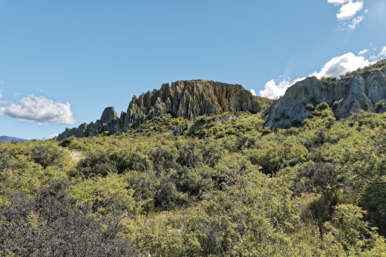
- Kura Tāwhiti Conservation Area: limestone outcrops in the tussock landscape, a place of great significance for Ngāi Tahu. The short path from the car park on SH73 leads in among the boulders – stay on the marked tracks, and do not write on the rocks or climb them where this is prohibited.
- Cave Stream Scenic Reserve: even without going through the cave, the short walk to where the stream emerges from the limestone is worthwhile; wading through the cave is only justifiable when the water is low and clear and with two light sources per person – do not go in when it is raining or the water is murky.
- Lake Pearson/Moana Rua: wildlife refuge with crested grebes and waterfowl; in the evening the Craigieburn Range and the Torlesse peaks are reflected in the lake.
- CampingSpirit overnight tip
-
Official campsite or RV park: Basic DOC campsite (Standard category) at Lake Pearson/Moana Rua, reached by a short gravel access road from SH73, also suitable for campervans and caravans: a meadow by the lake, no power, treat water before use. According to DOC, online advance booking only, with no sites for arrivals without a reservation; the DOC Campsite Pass is valid. If you need power and showers, you are better off staying in Christchurch or Springfield and driving on the next morning.
Free camping or nature tip (where legal): Selwyn District designates only a few freedom camping areas, such as Coes Ford, Chamberlains Ford and Whitecliffs Domain; there are none on Porters Pass or in the Castle Hill basin. The car parks at Kura Tāwhiti and Cave Stream are for day visitors only; on DOC land you may only stay overnight at campsites. Since 7 June 2026, private vehicles too may only freedom camp on public land with a green self-containment warrant.
- Insider tip for campers
- Fill up in Darfield or Springfield – there is no reliable petrol station from there until Kumara. In Sheffield, the well-known pie bakery is worth a stop. Drive down Porters Pass in a low gear and use the crawler lanes on the way up so that faster vehicles can overtake; in snow and ice the NZTA Journeys advisories apply on SH73 – carry snow chains.
2Stage 2: Lake Pearson/Moana Rua to Arthur’s Pass Village (approx. 40 km)
- The drive
- A short driving day: over the saddle at Cass down into the broad shingle bed of the Waimakariri, across the long bridge at Klondyke Corner and up the Bealey Valley to Arthur’s Pass village at around 740 m. About 40 minutes of pure driving time, leaving plenty of time for walks in Arthur’s Pass National Park, the South Island’s first national park.
- Highlights & must-sees
- Bealey Spur Track: from the small settlement of Bealey Spur through mountain beech forest onto a ridge with views over the braided riverbed of the Waimakariri; even the first one to two hours are worthwhile.
- Devil’s Punchbowl Falls: from the village over bridges and steps to the waterfall, around 130 m high; early in the morning you will have it almost to yourself.
- Visitor centre and railway station: exhibitions on road and railway building, current weather and avalanche conditions; the TranzAlpine stops here before entering the Otira Tunnel beneath the pass.
- CampingSpirit overnight tip
-
Official campsite or RV park: In the village, the DOC campsite Avalanche Creek Shelter lies opposite the visitor centre, according to DOC bookable in advance only; somewhat quieter is Klondyke Corner further down the valley (also booking only, basic facilities). There is no conventional holiday park with power in Arthur’s Pass – sort out water and waste disposal beforehand.
Free camping or nature tip (where legal): Throughout the national park, sleeping in your vehicle is only permitted at DOC campsites; trailhead car parks, lay-bys and the car park at the pass are off limits and are patrolled. Even with a green warrant, the rule on DOC land is: only where DOC expressly permits it.
- Insider tip for campers
- Kea are strictly protected and curious: they take apart wiper blades, window seals, roof rubbers, bike saddles and aerials. Leave nothing lying outside, cover the roof box and bikes, close the windows and roof hatch when you go walking, and never feed the birds – fed kea become more brazen and put themselves at risk on the road. Supplies in the village are very limited; bring food from Christchurch.
3Stage 3: Arthur’s Pass Village to Greymouth via Otira and Kumara (approx. 100 km)
- The drive
- From the village up to the summit of the pass (around 920 m), then the most spectacular section: down through the Otira Gorge, over the curving Otira Viaduct and beneath rockfall shelters and avalanche galleries, with gradients of up to about 16%. Further down the valley widens, and the road follows the Taramakau via Otira and Jacksons into the rainforest to Kumara and the coast at Kumara Junction, then north on SH6 to Greymouth. A good 1.5 hours of pure driving time. If you like, you can make a short detour south from Kumara Junction to Hokitika (about 50 km extra there and back).
- Highlights & must-sees
- Otira Viaduct Lookout on SH73 below the summit: views of the curving bridge and the steep flanks of the gorge; kea often gather here – do not leave your vehicle open and unattended.
- Otira, with the old railway station at the western portal of the Otira Tunnel, through which trains have run beneath the pass since 1923.
- Kumara: gold-mining town from 1876 with the restored Theatre Royal Hotel; this is also the start of the West Coast Wilderness Trail, a cycle trail towards Greymouth and Hokitika.
- CampingSpirit overnight tip
-
Official campsite or RV park: Greymouth has several holiday parks with power, toilets and showers and a dump station, for example right by the sea south of the mouth of the Grey. If you would rather stay in the forest, you will find small DOC sites between Otira and Jacksons; check facilities and booking requirements on the DOC website.
Free camping or nature tip (where legal): In Grey District, certified self-contained vehicles may stay on council land for a maximum of two consecutive nights at the same location; exceptions include parts of Cobden (beach, breakwater), Rapahoe, Blaketown and the shore of Lake Brunner at Moana. Westland District (Responsible Freedom Camping Bylaw 2024) permits freedom camping in Kumara and Hokitika only in certain areas, for a maximum of two nights at the same location within 30 days; many smaller towns are prohibited zones. The councils and CamperMate show the current maps. The fine for violations is NZ$400.
- Insider tip for campers
- The Otira side is the steepest stretch of the loop: check your brakes and gear before the descent, drive in second gear, and give trucks and rigs room. In heavy rain, snow or rockfall NZTA closes SH73 between Otira and Arthur’s Pass, sometimes at short notice – check the status on NZTA Journeys and plan a buffer day. Shop, fill up and swap gas bottles in Greymouth: shops and petrol stations are few and far between until Hanmer Springs.
4Stage 4: Greymouth to Reefton via Brunner Mine (approx. 80 km)
- The drive
- Up the valley of the Grey River on SH7: after a few kilometres the Brunner Mine near Stillwater, then through farmland and remnants of rainforest via Ngahere and Ikamatua to Reefton. A wide, quiet road with a few one-lane bridges, about 1 hour of pure driving time. Optionally, a detour from SH7 to the ghost town of Waiuta, the last few kilometres on gravel.
- Highlights & must-sees
- Brunner Mine Site (DOC): ruins of coke ovens, a brickworks and winding gear on the Grey River; in 1896, 65 miners died here in a gas explosion – the country’s worst mining disaster. The suspension bridge over the river links the two banks of the site.
- Waiuta: ruins and a few houses of a gold-mining settlement abandoned after the main shaft collapsed in 1951; tracks to remains of shafts and the battery.
- Reefton: in 1888 one of the first towns with a public electricity supply; a short Powerhouse Walk to the old hydroelectric station, and Victorian facades on Broadway.
- CampingSpirit overnight tip
-
Official campsite or RV park: Reefton Motor Camp on Broadway in town, next to the skatepark and outdoor pool, with powered sites, kitchen and laundry. Around 10 km south, on a gravel access road off SH7, lies the DOC campsite Slab Hut Creek: no power, toilets, stream water, self-registration without booking – bring cash, and if in doubt boil the water.
Free camping or nature tip (where legal): In Buller District (Reefton), only certified self-contained vehicles may freedom camp, for a maximum of two nights at one location and nine nights per calendar month; Bridge Street in Reefton is a prohibited zone. On the Strand by the Inangahua riverbank there is a free freedom camping area for certified vehicles (around ten sites, no reservation) with public toilets and a dump station nearby; boil the water there before drinking. The council is revising its bylaw, so pay attention to signs.
- Insider tip for campers
- Reefton is the last proper supply stop before the Lewis Pass: fill up, top up your drinking water (if in doubt, only use public taps after boiling) and empty your tanks. From Brunner to Reefton the railway line runs alongside you; at level crossings without barriers, stop and look – coal trains are long.
5Stage 5: Reefton to Maruia Springs (approx. 60 km)
- The drive
- On SH7 over the Rahu Saddle: winding through dense beech forest, with wide views of the Victoria Range at the saddle, then through the Maruia Valley to Springs Junction, where SH65 branches off to Murchison. Continue along the Maruia River to Maruia Springs. Just under 1 hour of pure driving time, leaving time for a longer walk.
- Highlights & must-sees
- Lake Daniell Track from the DOC campsite Marble Hill: a largely level track through red beech forest to the lake at the foot of the mountains, a long day there and back; shorter is the detour to Sluice Box Gorge, a narrow rock gorge of the Maruia.
- Springs Junction and Marble Hill lie close to the Alpine Fault, the South Island’s great plate boundary; information panels in the area explain why the Alps are growing so fast here.
- Maruia Hot Springs: thermal pools in the forest by the river with a bathhouse; check opening days and facilities with the operator in advance.
- CampingSpirit overnight tip
-
Official campsite or RV park: DOC campsite Marble Hill on SH7, around 6.5 km east of Springs Junction: a large meadow at the edge of the forest, also suitable for campervans and caravans, boil or treat water; according to DOC online booking only, with no sites for arrivals without a reservation, DOC Campsite Pass valid. Ask the operator in advance whether Maruia Hot Springs offers sites for campers.
Free camping or nature tip (where legal): The section from Springs Junction to Lewis Pass lies in the Lewis Pass Scenic Reserve (DOC); overnight stays are only permitted at the campsites, not in car parks and rest areas on SH7. North and west of Springs Junction, Buller District rules apply.
- Insider tip for campers
- Sandflies are numerous in the Maruia Valley on still evenings: close the insect screens and wear long sleeves at the campfire. There is no mobile coverage along large parts of SH7 between Reefton and Hanmer – check bookings and the weather forecast in Reefton.
6Stage 6: Maruia Springs to Hanmer Springs via the Lewis Pass (approx. 80 km)
- The drive
- A few kilometres to the Lewis Pass (around 860 m), the lower and considerably gentler of the two passes on this loop – moderate gradients, hardly any hairpins, and the more comfortable alpine crossing for rigs too. Then down through beech forest along the Lewis and Boyle rivers, past the end of the St James Walkway at Boyle Village and through the Hope Valley to the Waiau bridge, where the road to Hanmer Springs branches off. About 1.5 hours of pure driving time with several one-lane bridges.
- Highlights & must-sees
- Short loop walk at the summit to tarns with alpine plants and views of the surrounding peaks – ideal in the morning before the clouds roll in.
- St James Walkway: the multi-day track (around 66 km) starts at the Lewis Pass and ends at Boyle Village; as a day walk, the section from the pass to the first clearings in the Ada River valley is worthwhile.
- Sylvia Flats: riverbank area on the Lewis River where warm springs emerge from the gravel when the water is low – only when the river is calm, and do not put your head under water (there can be a risk of amoebae in thermal water).
- CampingSpirit overnight tip
-
Official campsite or RV park: On the way, east of the summit, lies the basic DOC campsite Deer Valley on the Lewis River (gravel access road, according to DOC online booking only). Hanmer Springs has several holiday parks with power, toilets and showers and a dump station; book early for weekends and school holidays.
Free camping or nature tip (where legal): Under the Hurunui District Council’s Freedom Camping Bylaw 2025, Hanmer Springs is a prohibited zone, with a few narrowly defined exceptions. Outside the town, designated areas and length-of-stay limits apply in Hurunui District; on DOC land, campsites only.
- Insider tip for campers
- Hanmer Springs in brief: the Thermal Pools & Spa in the town centre are within walking distance of the holiday parks, while the town itself is cramped and busy at weekends – leave the camper at the site. The town has a supermarket and a petrol station; the next one after that is in Culverden.
7Stage 7: Hanmer Springs to Christchurch via Waipara (approx. 140 km)
- The drive
- Back to the Waiau bridge and on SH7 through the wide Amuri Basin via Culverden and Waikari, through the limestone hills of the Weka Pass down into the Waipara Valley, and at Waipara south onto SH1. From Kaiapoi, take the Northern Motorway into the city. Wide and straightforward, about 2 hours of pure driving time.
- Highlights & must-sees
- Weka Pass Railway: heritage railway on the old line between Waipara and Waikari through the limestone rocks of the Weka Pass; operating days are limited, so check the timetable in advance.
- Waipara Valley: small wineries with cellar doors along SH1 and the side roads; a dry, warm climate for Pinot Noir and Riesling – plan your tastings or choose a designated driver.
- Waikari: a small town at the foot of the Weka Pass with an old hotel and views over the Hurunui hills.
- CampingSpirit overnight tip
-
Official campsite or RV park: For the last night before returning a rental vehicle, Christchurch has several holiday parks with power and a dump station near the airport and in the north of the city, for example North South Holiday Park near the airport.
Free camping or nature tip (where legal): Christchurch only allows freedom camping for certified vehicles in the coastal zone, for a maximum of four nights in 30 days; in parks and reserves, camping outside the council campgrounds is prohibited. In the Waipara Valley there are no designated areas at the wineries – overnight stays there only with express permission.
- Insider tip for campers
- Before returning the vehicle: empty the cassette and grey-water tank, and refill fresh water and gas as required by the rental agreement. For diesel rental vehicles, note the kilometres for Road User Charges in case the agreement bills them separately.
Camping practice & local rules
Wild camping & overnight parking
- Self-Contained Motor Vehicles Legislation Act 2023: freedom camping in a vehicle on council and other public land is only permitted with a certified self-contained vehicle and a green warrant, unless a council expressly designates areas for other vehicles. Rental vehicles have needed one since 7 December 2024, private vehicles since the transition period ended on 7 June 2026; a fixed toilet is a requirement. The fine is NZ$400, passed on with an administration fee for rental vehicles.
- This loop passes through five districts with their own rules: Selwyn (only a few designated areas), Westland (a maximum of two nights per location in 30 days), Grey (a maximum of two nights at the same location), Buller (bylaw under review, so far a maximum of two nights at one location and nine per month) and Hurunui (Bylaw 2025, Hanmer Springs a prohibited zone). Christchurch restricts the coastal zone to four nights in 30 days. Signs on site take precedence.
- DOC land: in Arthur’s Pass National Park and Lewis Pass Scenic Reserve, overnight stays are only permitted at DOC campsites. Many, including Lake Pearson/Moana Rua, Avalanche Creek, Klondyke Corner, Marble Hill and Deer Valley, can only be used with online advance booking, with no sites for arrivals; others, such as Slab Hut Creek, still work with self-registration. The DOC Campsite Pass for rental vehicles is valid at many, but does not replace booking.
- Apps: CamperMate shows council areas, dump stations and road advisories, and WikiCamps adds user reports. For campsites and track closures use the DOC website, for roads NZTA Journeys.
Waste disposal & supplies
- Dump stations: Christchurch, Greymouth and Reefton (on the Strand) have stations open to the public, plus the holiday parks in Greymouth, Reefton and Hanmer Springs. Between Springfield and Kumara and between Reefton and Hanmer there are practically none – tackle the passes with empty tanks. Never empty grey water or the cassette into streams, drains or the countryside.
- Water: generally drinkable in Christchurch, Greymouth and Hanmer Springs; at DOC campsites, stream or tank water is usually untreated – boil or filter it. In small towns, look out for boil-water notices.
- Gas: the standard is 9 kg LPG bottles, which are swapped or refilled at petrol stations and hardware stores, only with a valid test date. European bottles and fittings do not fit. Swap points in Christchurch, Greymouth and Hanmer Springs.
- Fuel: the last reliable petrol stations before the passes are Darfield/Springfield (east), Greymouth and Reefton (west), and Hanmer Springs and Culverden (north). There is no longer a reliable petrol station in Arthur’s Pass village, and you should not rely on the single station in Springs Junction either. In New Zealand, diesel vehicles pay Road User Charges instead of fuel tax – with rental vehicles, check how this is billed.
Vehicle size & traffic rules
- Driving on the left: roundabouts are driven clockwise, and traffic from the right has priority. There are many one-lane bridges on SH7 and SH73 – the large white arrow means you have priority, the small red arrow means wait.
- Speed limits: 100 km/h outside towns, 50 km/h in towns, often 80, 60 km/h or less in gorges and through towns. Vehicles over 3.5 t and rigs a maximum of 90 km/h. There are no toll roads on this loop.
- Passes: the Otira side of Arthur’s Pass has gradients of up to about 16%, rockfall shelters and tight bends – drive large motorhomes and rigs slowly and in a low gear. The Lewis Pass is flatter. In winter, snow chains may be mandatory on both passes, and in severe weather NZTA closes SH73, sometimes at short notice; check the status on NZTA Journeys and the weather at MetService.
- Animals: do not feed or lure kea at car parks or at the Otira Viaduct; sheep, cattle and stock droves on the road have right of way, and at night possums run across the road.
- Rental campervans and insurance: many rental agreements wholly or partly exclude gravel roads from insurance cover – affected here are, for example, the access roads to Waiuta, Slab Hut Creek and Deer Valley. Foreign driving licences are valid for up to twelve months if they are in English or presented with an approved translation or an International Driving Permit.
- Alcohol and phones: for drivers aged 20 and over the limit is 0.05%, below that zero – bear this in mind at the wineries in the Waipara Valley. Phones only in a fixed mount; seat belts are compulsory in all seats. Emergency number 111; between Reefton and Hanmer and in the Otira Gorge there is often no signal.
CampingSpirit packing & preparation checklist
- Snow chains to fit your tyre size – they can be mandatory on SH73 in winter and in the shoulder seasons, and not every rental vehicle carries them.
- Covers and straps for the roof box, bikes and wipers: kea take apart anything made of rubber or foam.
- Two head torches per person, neoprene socks and warm spare clothes for Cave Stream – the water is ice-cold even in summer.
- Sandfly repellent and a fine-mesh mosquito net for the sliding door and roof hatch – essential on the West Coast and in the Maruia Valley.
- Water filter, or a stove with spare gas, for untreated water at DOC campsites.
- Offline maps and printed DOC booking confirmations: reception between Reefton and Hanmer is patchy.
As of 2026-10. Closures, fees and booking rules change: check official sources before you go.