

In-depth guide · CampingSpirit
Around 900 kilometres north: over the Tombstone Range and the Ogilvie Mountains, through Eagle Plains and across the Arctic Circle, with two river ferries into the Mackenzie Delta to Inuvik and on the Inuvik–Tuktoyaktuk Highway to the Arctic Ocean.
The spirit of the route
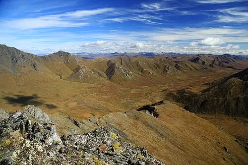
The Dempster is not a road you drive in passing. Beyond Dempster Corner the asphalt ends, and for the next 736 kilometres to Inuvik grey, sharp-edged gravel crunches under your tyres. The forests thin out, then only dwarf birch and cotton grass stand in the tundra, with the jagged peaks of the Tombstones above them and, later, the rounded, bare summits of the Richardson Mountains. If you open the sliding door in the evening in June, you see no dusk, but light that sweeps across the hills for hours, and you hear nothing but wind and mosquitoes. Ferries wait at the Peel River and the Mackenzie, and in Fort McPherson and Tsiigehtchic the Gwich’in have lived along the rivers for thousands of years. Beyond Inuvik, since 2017 a highway has led across permafrost and lake country to Tuktoyaktuk, where you can dip your hand into the Arctic Ocean. The way back follows the same route – and in the opposite direction it is a new landscape.
Stage-by-stage plan
1Stage 1: Dawson City to Tombstone Territorial Park (approx. 115 km)
- The drive
- About 40 km east on the paved North Klondike Highway to Dempster Corner, then onto the Dempster Highway (Yukon Hwy 5). From here it is gravel: narrow, dusty when dry, slippery in the rain. Through spruce forest into the valley of the North Klondike River and up into the tundra. About 2 hours of driving time. Dawson and this first section are described in detail in the CampingSpirit guide to the Klondike Highway – here you get only the essentials for setting off north.
- Highlights & must-sees
- Dempster Corner with the highway’s welcome sign – the photo stop where many travellers gather themselves one more time before the gravel.
- Tombstone Interpretive Centre at the campground (Dempster km 72): exhibition on permafrost, tundra and the culture of the Tr’ondëk Hwëch’in, advice on hikes and current road conditions; open seasonally.
- Short interpretive trails around the campground or a detour to the Grizzly Lake Trailhead with a view of Tombstone Mountain.
- CampingSpirit overnight tip
-
Official campsite or RV park: Tombstone Mountain Campground (Yukon Government) at km 72: 51 sites, only one of them pull-through, cooking shelter, bear-proof food lockers, fire pits, pit toilets, no hookups and no drinking water. Some sites can be reserved via yukon.goingtocamp.com; the rest are first come, first served and fill up early in high summer.
Free camping or nature tip (where legal): In Tombstone Territorial Park, overnighting at the roadside is prohibited; every night requires a campground site or a permit from the park administration. Before the park, in the North Klondike valley, there are gravel areas on public land where the Yukon rule applies: at least 30 m from the centre of the road, not on Settlement Land.
- Insider tip for campers
- In Dawson, fill up, top up your fresh water, empty your grey water and buy all supplies for at least four days: the next fuel station is not until Eagle Plains, around 370 km beyond Dempster Corner. Don’t rely on the fuel station at the junction. Lower your tyre pressure slightly for gravel, but not below the manufacturer’s figure for your load.
2Stage 2: Tombstone Territorial Park to Engineer Creek (approx. 122 km)
- The drive
- Over North Fork Pass, the divide between the Yukon and Mackenzie systems, down into the wide Blackstone Uplands with lakes and tundra, then through the Ogilvie Mountains over Windy Pass into the valley of Engineer Creek. The road alternates between firm gravel, loose chippings and stretches of shale. A good 2 hours of driving time; with photo and wildlife stops, a full day.
- Highlights & must-sees
- North Fork Pass: the highest point on the Yukon section, with a view back to the Tombstone Range.
- Blackstone Uplands and Chapman Lake: one of the best birdwatching areas on the Dempster, with waders and waterfowl at the end of June; floatplanes land on Chapman Lake.
- Sapper Hill at Engineer Creek: rust-red, weathered rock towers right beside the road, named after the military engineers who built bridges here.
- CampingSpirit overnight tip
-
Official campsite or RV park: Engineer Creek Campground (Yukon Government) at km 194: 11 sites by the creek, cooking shelter, pit toilets, firewood, no hookups and no drinking water. Self-registration at the kiosk, fee in cash or by voucher.
Free camping or nature tip (where legal): Between the Tombstone park boundary and Engineer Creek there are old gravel pits and road maintenance stockpiles; only park where no work is under way and no prohibition is signposted, 30 m from the centre of the road. Don’t cut tracks into the tundra – the vegetation does not recover for decades.
- Insider tip for campers
- The water of many creeks along the Dempster is heavily mineralised and partly discoloured by rock deposits; filtering and boiling help against germs, not against minerals. Carry drinking water for the whole Yukon section in your tank. With oncoming traffic, keep well to the right and slow right down – flying stones are the most common cause of windscreen damage.
3Stage 3: Engineer Creek to Eagle Plains (approx. 175 km)
- The drive
- North along the Ogilvie River, then up long switchbacks onto Ogilvie Ridge and on across a broad, forested ridge to Eagle Plains. Here the road often runs on a raised embankment above the permafrost, with wide views in every direction. Around 3 hours of driving time.
- Highlights & must-sees
- Ogilvie River valley with gravel bars and rock walls – bighorn sheep and caribou are possible, and in early summer also bears on the banks.
- Ogilvie Ridge Viewpoint with information panels on the geology and the construction of the highway, and a view over the valley and the Ogilvie Mountains.
- Eagle Plains: hotel, restaurant and repair shop halfway between Dawson and Inuvik – for decades the meeting point for everyone travelling the Dempster.
- CampingSpirit overnight tip
-
Official campsite or RV park: Eagle Plains Hotel and RV Campground (private, hotel open year-round) at km 369: RV park and campground with around 15 sites, plus restaurant, laundromat, fuel station and repair shop. It is the only services between Dempster Corner and Fort McPherson. Ask on site whether electric hookups, showers and water are available, and about prices.
Free camping or nature tip (where legal): Along the way there are several wide pull-outs and gravel pits on public land. Ogilvie Ridge is windy and exposed; for the night, choose a sheltered gravel area in the valley instead, and keep 30 m from the centre of the road.
- Insider tip for campers
- Fill up in Eagle Plains even if your tank is half full, and have your tyres checked: the repair shop fixes tyres, but spare tyres in unusual sizes are not in stock. It is around 180 km to the next fuel station in Fort McPherson. Fuel here is considerably more expensive than in Dawson.
4Stage 4: Eagle Plains to Nataiinlaii Territorial Park (Peel River) (approx. 170 km)
- The drive
- North across the Arctic Circle and into the Richardson Mountains: bare, rounded mountains, a gravel road with short climbs and plenty of wind. After the Rock River comes Wright Pass, the border with the Northwest Territories; from here the road is called NWT Hwy 8 and the kilometre markers start again. Descent into the valley of the Peel River to the first ferry. About 3 hours of driving time plus waiting time at the ferry.
- Highlights & must-sees
- Arctic Circle Crossing at km 405: sign and information panels at 66° 33′ north, rest area with a view across the tundra.
- Wright Pass on the Yukon/NWT border: a divide in the Richardson Mountains, in late summer often with caribou of the Porcupine herd nearby.
- Abraham Francis Ferry across the Peel River: a short crossing, with a view of the river’s banks from the landing.
- CampingSpirit overnight tip
-
Official campsite or RV park: Nataiinlaii Territorial Park (NWT Parks), about 1 km north of the Peel River ferry at NWT km 76: 22 non-powered sites, drinking water, showers, toilets, cooking shelter and a staffed visitor centre. No online reservations, registration on site; check operating dates on nwtparks.ca. If you want to stop earlier: Rock River Campground (Yukon Government) at km 446, a basic campground with 17 sites (3 pull-through), cooking shelter and pit toilet in a sheltered valley hollow – no drinking water, no reservations.
Free camping or nature tip (where legal): In the Richardson Mountains the terrain is open and very windy. The NWT side belongs to the Gwich’in Settlement Area; private land rights apply on Gwich’in land, and staying for longer only with permission. For the night, Rock River and Nataiinlaii are the simple, legal solution.
- Insider tip for campers
- Change your clock at the border: the Yukon stays on UTC−7 all year, while the NWT observe daylight saving time – in summer it is an hour later there. This matters for the ferry, which in season runs on demand daily from late morning until just after midnight. Schedule changes and cancellations due to high water are announced by the NWT Department of Infrastructure; ask in Eagle Plains before you set off.
5Stage 5: Nataiinlaii Territorial Park to Gwich’in Territorial Park (approx. 165 km)
- The drive
- A short way to Fort McPherson, then south-east through flat, forested country with lakes to the Mackenzie River. Across the Mackenzie on the second ferry (a detour to Tsiigehtchic on the far bank is possible), then along long straights through spruce and tamarack forest towards Inuvik. About 2.5 hours of driving time plus the ferry.
- Highlights & must-sees
- Fort McPherson (Teetł’it Zheh): Gwich’in community above the Peel River; the cemetery by the Anglican church holds the graves of the “Lost Patrol” of the Royal Northwest Mounted Police, who perished in the winter of 1910/11 on their way to Dawson.
- Louis Cardinal Ferry across the Mackenzie River at the mouth of the Arctic Red River: the ferry links the two highway banks and also calls at Tsiigehtchic on demand; the view of the mighty river is one of the highlights of the route.
- Tsiigehtchic: a small village on the spit of land between the rivers, with a white-and-red wooden church on the rise – reachable on foot from the ferry landing.
- CampingSpirit overnight tip
-
Official campsite or RV park: Gwich’in Territorial Park (NWT Parks) on Campbell Lake at NWT km 240: 25 non-powered sites plus tent sites, drinking water, cooking shelter, toilets, boat launch and swimming spot. Smaller and quieter: Vadzaih Van Tshik Campground at km 221 with 9 non-powered sites, drinking water and self-registration at the kiosk – no online reservations.
Free camping or nature tip (where legal): Around Fort McPherson and Tsiigehtchic the land is Gwich’in land and community land; don’t overnight there on your own initiative. The territorial parks are close enough together that you can manage without free camping.
- Insider tip for campers
- Fill up in Fort McPherson – petrol and diesel are available there, but opening hours are limited, especially at weekends. The ferry crews operate on request: wait at the landing until the ferry is on your bank, then drive on when directed. With long rigs, pay particular attention to the crew’s directions; the ramps are steep when the water is low.
6Stage 6: Gwich’in Territorial Park to Inuvik (approx. 30 km)
- The drive
- A short drive north to the end of the Dempster Highway. With just over 3,000 inhabitants, Inuvik is the largest community in Canada north of the Arctic Circle; houses and utility lines stand on stilts above the permafrost. A day for the town, supplies and laundry.
- Highlights & must-sees
- Our Lady of Victory, the “Igloo Church”: a round, white wooden church in the shape of an igloo, built in the late 1950s on a gravel foundation so that the permafrost does not thaw.
- Inuvik Community Greenhouse: a community greenhouse in a former ice arena, where vegetables and flowers grow under the midnight sun.
- Western Arctic Regional Visitor Centre and Jàk Territorial Park with a lookout tower over the Mackenzie Delta, hundreds of river channels and lakes to the horizon.
- CampingSpirit overnight tip
-
Official campsite or RV park: Happy Valley Territorial Park (NWT Parks) in town: 19 powered sites, 15 non-powered, drinking water, showers, toilets and a dump station (sani-dump). On the edge of town: Jàk Territorial Park with 10 powered and 26 non-powered sites, drinking water and showers. Permits and reservations via the NWT Parks online portal (nwtparks.ca) or on site; check operating dates.
Free camping or nature tip (where legal): Within Inuvik’s town limits, overnighting on streets and in car parks is not intended; the two territorial parks are the legal solution, and Happy Valley has the only reliable dump station between Dawson and Inuvik.
- Insider tip for campers
- Inuvik is the only place north of Dawson with a large supermarket, propane, repair shops and tyre service. Fill your gas here, have your tyres checked and wash your vehicle: the Dempster is treated with calcium chloride against dust, which builds up as a crust on the underbody and brakes. Food is expensive – if possible, bring basic supplies from Whitehorse.
7Stage 7: Inuvik to Tuktoyaktuk (Arctic Ocean) (approx. 140 km)
- The drive
- The Inuvik–Tuktoyaktuk Highway (NWT Hwy 10), opened in November 2017, is Canada’s first all-season road to the Arctic Ocean. A wide, high gravel embankment over permafrost, through tundra with thousands of lakes, dwarf shrubs and the first pingos. No settlements, no fuel station and no services along the way; the posted limit is 70 km/h. Around 2.5 hours of driving time, longer in rain or after frost heaves.
- Highlights & must-sees
- A few pull-outs along the highway – often the only chance to stop safely on the high embankment and look out over the lake country.
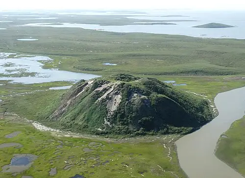
- Pingo Canadian Landmark on the edge of Tuktoyaktuk: eight ice-cored hills, among them Ibyuk, at 49 m the largest pingo in Canada. You get a good view of it from the pingo viewpoint on the highway and from the Parks Canada day-use area; the boardwalk can only be reached by paddling, hiking across the tundra to the pingos is not permitted in summer, and drones are prohibited.
- The end of the road at the Point in Tuktoyaktuk: the “Arctic Ocean” sign, a gravel beach and the chance to dip your hands or feet into the Arctic Ocean.
- CampingSpirit overnight tip
-
Official campsite or RV park: The community’s Tuktoyaktuk Arctic Ocean Campground (Hamlet of Tuktoyaktuk) right by the sea: according to The Milepost around 26 sites with electricity, water, toilets and a dump station, open roughly June to September, reservations through the hamlet office – have facilities and fees confirmed in advance. Another place to stay overnight is the Tuk Souvenir Store and Campground. There is no campground between Inuvik and Tuktoyaktuk.
Free camping or nature tip (where legal): The land along the Inuvik–Tuktoyaktuk Highway is largely Inuvialuit private land. Staying overnight at the pull-outs or camping off the road is not automatically permitted; ask the Inuvialuit Land Administration or the visitor information in Inuvik beforehand. The campground in Tuktoyaktuk is the simpler option.
- Insider tip for campers
- Fill up in Inuvik: Tuktoyaktuk does have fuel stations, but with limited opening hours, and propane is not reliably available there. The road is greasy in rain, and the embankment drops away steeply at the sides – never swerve onto the shoulder. Drive slowly in the village, where the streets are playground and workplace at once, and only photograph people and houses after asking.
8Stage 8: Tuktoyaktuk to Inuvik and return to Dawson City (approx. 140 km)
- The drive
- Back to Inuvik for supplies and a night, then the same route via the two ferries, Fort McPherson, Eagle Plains and Tombstone to Dawson City: around 780 km, a good 730 km of it gravel, realistically in two to three days. In the opposite direction, the Richardson Mountains and the Tombstones show a completely new side in the evening light.
- Highlights & must-sees
- In the morning in Tuktoyaktuk, take a look at the harbour and the fishing boats before heading back – in calm weather the sea lies smooth to the horizon.
- A stopover at Gwich’in Territorial Park or Nataiinlaii to split the drive into manageable stages.
- A second look at the Arctic Circle and the Blackstone Uplands – if you had fog on the way up, you get a second chance here.
- CampingSpirit overnight tip
-
Official campsite or RV park: In Inuvik, Happy Valley or Jàk Territorial Park again; for the return, Nataiinlaii or Rock River, then Eagle Plains or Engineer Creek and finally Tombstone Mountain Campground before you return to the asphalt towards Dawson.
Free camping or nature tip (where legal): The same rules apply on the way back: on Yukon public land 30 m from the road, in Tombstone Territorial Park only at the campground or with a permit, in the NWT on Gwich’in and Inuvialuit land only with permission.
- Insider tip for campers
- Before setting off from Inuvik, check the status of the ferries and the highway with the NWT Department of Infrastructure and on 511yukon.ca. After heavy rain the road in the Richardson Mountains or at river crossings can be closed because of washouts; plan a buffer day. Back in Dawson, thoroughly clean the underbody, radiator and air filter.
Camping practice & local rules
Wild camping & overnight parking
- Yukon: camping on public land is permitted without a permit, at least 30 m from the centre of the road; on private land and on First Nations Settlement Land only with permission. In Tombstone Territorial Park, overnighting is only permitted at the campground or with a permit from the park administration.
- Northwest Territories: a large part of the land along the Dempster belongs to the Gwich’in Settlement Area, and along the Inuvik–Tuktoyaktuk Highway to Inuvialuit private land. Private land rights apply there – clear any overnight stay outside the parks with the relevant land administration beforehand. The NWT territorial parks are sensibly spaced and are the reliable solution.
- Yukon Government campgrounds (Tombstone, Engineer Creek, Rock River): self-registration at the kiosk, payment in cash on site (2026: CAD 20 per night) or cheaper by voucher or online reservation where offered. Fees apply from 1 May to 30 September; after that no fee, but no services. A maximum of 14 nights in 28 days, quiet hours 11 pm to 7 am.
- NWT Parks (Nataiinlaii, Vadzaih Van Tshik, Gwich’in, Jàk, Happy Valley): a camping permit is required for every night, available via the NWT Parks online portal (nwtparks.ca) or on site; Nataiinlaii and Vadzaih Van Tshik cannot be booked online. Check fees and operating dates on nwtparks.ca every year – some parks close as early as late summer.
- Bears, wolves and caribou: grizzlies roam the entire Dempster. At night, keep food, cool box, dishes and rubbish in the closed vehicle or in bear-proof lockers, with bear spray within reach. Never feed wildlife, and pass caribou herds on the road slowly and at a distance.
- Useful apps and sites: iOverlander, Park4Night and Campendium for reports on gravel areas; Yukon road conditions on 511yukon.ca, NWT highways and ferries from the Department of Infrastructure (inf.gov.nt.ca, phone 1-800-661-0750).
Waste disposal & supplies
- Fuel stations: Dawson City, then not until Eagle Plains (around 370 km from Dempster Corner), Fort McPherson (around 180 km further), according to Parks Canada also Tsiigehtchic, then Inuvik and Tuktoyaktuk. The fuel station at Dempster Corner is not reliable. Rule of thumb: fill up at every fuel station; a 20-litre reserve jerrycan does no harm.
- Drinking water: the Yukon campgrounds on the Dempster supply no drinking water; the NWT parks Nataiinlaii, Vadzaih Van Tshik, Gwich’in, Jàk and Happy Valley have drinking water. Fill your tank in Dawson for the Yukon section; creek water is often heavily mineralised.
- Waste disposal: sani-dump in Dawson City (private RV parks, fuel stations) and in Happy Valley Territorial Park in Inuvik, as well as at the community campground in Tuktoyaktuk. No reliable station between Dawson and Inuvik – start with a full fresh-water tank and an empty grey-water tank. Only empty chemical toilets at dump stations.
- Propane: in Dawson City and Inuvik, not reliably in Tuktoyaktuk. Canada uses North American fittings; European cylinders are usually not refilled, and rental campers have built-in tanks.
- Repair shops and tyres: Eagle Plains and Inuvik repair tyres and minor damage; towing over long distances is extremely expensive. Shopping: a large selection only in Whitehorse and a limited one in Dawson and Inuvik; in Fort McPherson and Tuktoyaktuk, small shops with high prices.
- Mobile coverage: between Dawson and Inuvik there is almost no signal anywhere, with exceptions around Eagle Plains and the communities. Carry a satellite messenger or satellite phone for emergencies.
Vehicle size & traffic rules
- Gravel road: the Dempster Highway (Yukon Hwy 5 / NWT Hwy 8) and the Inuvik–Tuktoyaktuk Highway (NWT Hwy 10) are unpaved. Observe the posted speed limits (70 km/h on the Inuvik–Tuktoyaktuk Highway); realistically 50–70 km/h depending on conditions. Keep your lights on during the day too, and brake hard for oncoming traffic and dust.
- Tyres: light-truck tyres with reinforced sidewalls (LT, Load Range E) are ideal; at least one full-size spare, better two, plus a compressor and repair kit. The most common damage is sidewall cuts from sharp-edged shale.
- Rental agreements: many rental companies exclude the Dempster and the Inuvik–Tuktoyaktuk Highway or only allow them with a surcharge and restricted insurance. Get it confirmed in writing beforehand; otherwise the renter bears the full cost of damage on excluded routes.
- Ferries: the Abraham Francis Ferry (Peel River) and the Louis Cardinal Ferry (Mackenzie River) run free of charge from about early June to mid-October, daily from late morning until after midnight; in winter, ice roads replace the ferries. During break-up in spring and freeze-up in autumn there is neither ferry nor ice road for several weeks – the NWT section is then unreachable from Dawson. In high water or with driftwood, the ferries can pause even in summer.
- Closures: heavy rain, snow (possible on the passes in any month) and washouts repeatedly lead to short-notice closures. Check the status before you start and along the way on 511yukon.ca or with the NWT highway information.
- Time zones: the Yukon stays on UTC−7 all year, while the NWT switch to daylight saving time in summer – beyond Wright Pass it is an hour later in summer. No tolls, no low-emission zones; there is no winter tyre requirement, but from September winter tyres are still strongly recommended.
CampingSpirit packing & preparation checklist
- Two full-size spare wheels, or one spare plus a puncture kit with a 12 V compressor – the Dempster’s shale slashes tyre sidewalls, and the next repair shop can be 300 km away.
- Stone-chip protection: a front grille guard or protective film for headlights and radiator, plus a repair kit for small windscreen chips.
- Head net, insect screens for the sliding door and roof hatch, and strong mosquito repellent: in June and July, mosquitoes and blackflies in the tundra and along the Mackenzie are extreme.
- Two 20-litre jerrycans for drinking water and one for diesel or petrol – on the Yukon section there is no drinking water and, over long stretches, no fuel.
- Satellite messenger (e.g. with SOS and messaging functions), plus offline maps and the kilometre list of campgrounds and fuel stations.
- Bear spray with holster and blackout curtains for the midnight sun – in late summer, also warm layers for night frost.
As of 2026-10. Closures, fees and booking rules change: check official sources before you go.