

In-depth guide · CampingSpirit
From Parikia via Lefkes and Naoussa to Antiparos, then by ferry to Naxos with the Portara, Halki and Apeiranthos: around 155 kilometres of island hopping in which the ferry is a fixed part of the route.
The spirit of the route
The Cyclades are not classic camper country, and that is their appeal. Instead of long motorway stages, you plan around ferries, harbours and coastal roads that wind through villages. From your sliding door you see whitewashed walls, chapels on rocks, windmills and a sea in shades of blue that change through the day. On Paros a marble-paved path leads from Lefkes to Prodromos, and in Naoussa the fishing boats lie in front of the tavernas. On Naxos the Portara stands as a gateway without a temple at the harbour, olive groves rustle in the Tragea valley, and the lanes of Apeiranthos are made of marble. The price is patience: small campsites, narrow roads, the meltemi and ferry timetables that follow the wind. If you travel with open eyes and enough time, you get islands that have far more to offer than beaches.
Stage-by-stage plan
1Stage 1: Parikia port (Paros) to Parikia (approx. 5 km)
- The drive
- The ferry from Piraeus, Rafina or Lavrio docks at Parikia on the west coast of Paros. From Piraeus the crossing takes roughly three to five hours depending on the vessel (high-speed ferries are shorter, conventional ferries with intermediate stops longer); from Rafina it is usually three and a half to four hours. From Lavrio there are only a few, very long connections. Cyclades ferries stop only briefly: vehicles drive off quickly down the ramp on the crew’s instructions, often in tight succession with buses and lorries. Just behind the harbour the narrow waterfront road of Parikia begins, with one-way systems and plenty of pedestrians. It is only a few kilometres to the sites on the edge of town, but with a long motorhome they are demanding.
- Highlights & must-sees
- Panagia Ekatontapyliani (“Church of a Hundred Doors”) near the harbour: a Byzantine complex with a domed church, chapels and an ancient baptistery; the start of construction is not reliably documented.
- Kastro of Parikia: remains of a Venetian fortification with ancient marble columns and pieces of entablature built into its walls.
- Old-town lanes with white houses, bougainvillea and small tavernas; in the evening, a stroll along the harbour promenade.
- CampingSpirit overnight tip
-
Official campsite or RV park: According to OpenStreetMap there are two campsites on the edge of Parikia: Koula Camping north-east of the centre and Krios Beach Camping on the other side of the bay. Both are small and geared to tents and small vehicles; whether electricity and a waste disposal point for motorhomes are available and what length is possible, you should clarify with the site beforehand. Sites like these in the Cyclades are usually open only in the summer half of the year.
Free camping or nature tip (where legal): Wild camping is prohibited (see the legal situation below). At the harbour and on the waterfront in Parikia there are paid, taxi and bus areas with bans; do not count on an overnight spot in the centre. Parking a correctly parked vehicle is allowed where no signs say otherwise, but a table, chairs and an awning already count as camping.
- Insider tip for campers
- Do not drive into the centre unless you have a specific site: turning round there is almost impossible. If you are using a rental vehicle, it is better to pick it up outside the harbour. Fill up and shop on the edge of town before heading into the villages; inland, shops are small and petrol stations rare.
2Stage 2: Parikia to Lefkes (approx. 12 km)
- The drive
- From Parikia the country road leads east into the interior, climbing steadily. The section to Lefkes is paved and easy to drive in a car or small motorhome; a good 20 minutes of pure driving time. Shortly before the village the road narrows, and oncoming buses are normal. In Lefkes itself the lanes are too narrow for vehicles; the place is a pedestrian village.
- Highlights & must-sees
- Marathi: the ancient marble quarries that supplied the famous Parian marble (“Lychnites”); tunnels and traces of quarrying can be seen, so bring a torch and check the condition on site.
- Lefkes: white houses arranged like an amphitheatre on the hillside, the main street Ramnos and the church of Agia Triada, built of Paros marble in 1835.
- Byzantine Road from Lefkes to Prodromos: a marble-paved path of around 3.5 km, mostly downhill and walkable in about 45 minutes, with views of Naxos.
- CampingSpirit overnight tip
-
Official campsite or RV park: There is no campsite and no pitch in the village. Keep overnighting at one of the sites near Parikia or Naoussa and visit Lefkes as a day trip.
Free camping or nature tip (where legal): You may park in the areas at the entrance to Lefkes unless signed otherwise; staying overnight on the slope is not intended. In the pine-covered slopes above, the wildfire risk is higher in summer: no fires, no barbecues, no candles outdoors.
- Insider tip for campers
- Walk the Byzantine Road in the morning, before the sun beats down on the slope, and arrange your return in advance: either back to the car (bus or taxi from Prodromos) or as a circular walk. Drive the mountain stretch with an empty grey-water tank; it saves weight on the climbs.
3Stage 3: Lefkes to Naoussa (approx. 18 km)
- The drive
- From Lefkes you head via Prodromos down to the north coast and on towards Naoussa. The road is winding and in places narrow, with walls at the roadside and oncoming traffic in the villages; around 25 to 30 minutes of pure driving time. Naoussa itself has a tight centre, partly one-way, that you are better off avoiding with larger vehicles.
- Highlights & must-sees
- Prodromos: a small white village at the end of the Byzantine Road, quiet and without through traffic.
- Naoussa: fishing harbour with a traditional fishing fleet, the Venetian Kastelli at the edge of the harbour and tavernas in the former warehouses.
- Kolymbithres and Monastiri: bays with granite rocks in the Bay of Naoussa; the beaches are exposed in rough seas.
- CampingSpirit overnight tip
-
Official campsite or RV park: In the Naoussa area, according to OpenStreetMap, there are Blue Aura (paroscamping.gr) and Camping Santa Maria on Santa Maria beach; for a further site near Agii Anargyri no reliable evidence was found. The details are not official: a portal describes Blue Aura near Livadia as mainly tent-oriented, but motorhomes and vans have stayed there; ask the operator directly about length, electricity, waste disposal and opening times (usually June to September).
Free camping or nature tip (where legal): The same applies here: parking yes, camping no. At the harbour and around the Kastelli there are paid areas and closures; at Kolymbithres beach the access roads are narrow. Overnighting in your vehicle in beach car parks is risky, and checks are possible.
- Insider tip for campers
- Park on the edge of Naoussa and walk the last stretch. The harbour is full in the evening, so it is better to arrive in the late afternoon and eat early. In the meltemi (July/August) the wind blows strongly on the north side: keep the awning retracted and avoid beach car parks with the rear of the vehicle facing the wind.
4Stage 4: Naoussa to Antiparos (Pounta) (approx. 20 km)
- The drive
- From Naoussa back towards Parikia and on south to the ferry port of Pounta on the west coast, the crossing point to Antiparos. The route is well built, with a few places to drive through; around 30 minutes of pure driving time. The short crossing (around seven minutes) is served by small car ferries; tickets are sold on board, reservations are not possible, and in summer you may not get on the first ferry. For large motorhomes the vehicle deck is tight: ask the port authority beforehand, and if in doubt leave the vehicle in the car parks at Pounta and travel as a foot passenger (car ferry or passenger-only ferry from Parikia). Clarify fees and parking duration on site.
- Highlights & must-sees
- Antiparos town: car-free lanes, flowers and the 15th-century Venetian kastro with its houses arranged in a ring.
- Cave of Antiparos: a stalactite cave in the south of the island; the descent is via around 400 steps to a depth of about 85 m. It is open mainly in the summer half of the year, in winter only by arrangement with the municipality; because of the high humidity it is not suitable for people with heart or respiratory problems. Bring water, as there is no shop nearby.
- Despotiko: an uninhabited neighbouring island with an archaeological sanctuary of Apollo, reachable only by boat; whether and when the site is accessible depends on excavation and visitor operations, so find out beforehand.
- CampingSpirit overnight tip
-
Official campsite or RV park: On Antiparos, OpenStreetMap lists Camping Antiparos north of the main town. Overnighting in a tent or small vehicle is most realistic there; whether the site is regularly open and admits vehicles, you should clarify beforehand. Alternative: stay overnight in Naoussa/Parikia and cross over only during the day.
Free camping or nature tip (where legal): The motorhome is best left in the car parks at Pounta; camping on the beach is prohibited on Antiparos too. On the island there are checks and in places parking bans outside the villages.
- Insider tip for campers
- The island is small and is best experienced on foot and by bicycle. You hardly need a rental vehicle or scooter on the island. Pack a day rucksack, water and sun protection, because the beaches have little shade.
5Stage 5: Antiparos (Pounta) to Naxos (Chora) (approx. 15 km)
- The drive
- Back to Parikia (around 9 km from Pounta), where you board a ferry to Naxos again; the crossing takes around 25 to 30 minutes with high-speed ferries and about 50 to 55 minutes with conventional ferries. The timetable is seasonal and changes; conventional ferries usually take motorhomes. High-speed ferries do not always have a vehicle deck and often impose tighter length and height limits; have the carriage of your vehicle confirmed before booking. On Naxos the ferry docks at the quay of the main town (Chora), from where it is only a few kilometres to the campsites in the south.
- Highlights & must-sees
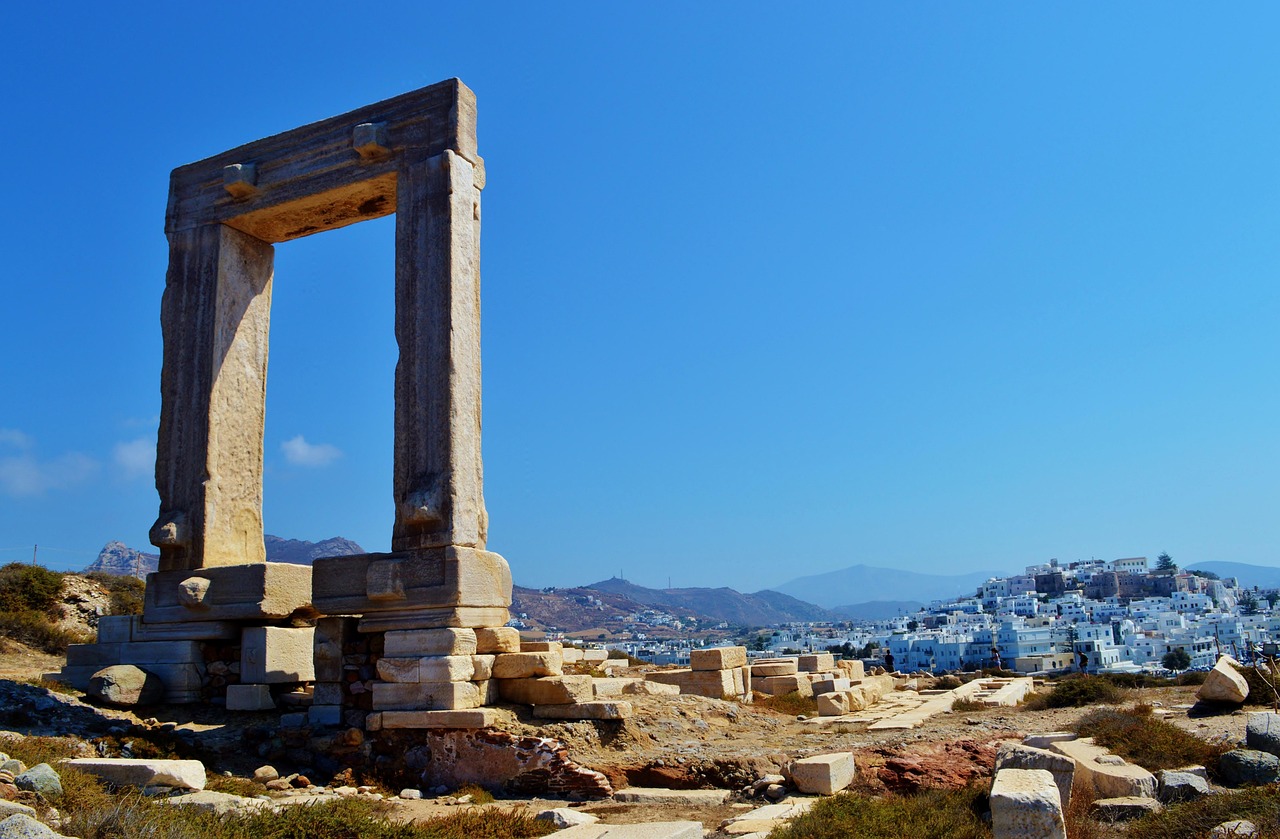
- Portara: the marble gateway of the unfinished Temple of Apollo on the island of Palatia, begun around 530 BC and connected to the town by a causeway; full at sunset, quieter earlier in the day.
- Kastro and old town (Bourgos): Venetian lanes with archways and houses from the Sanudo period; the Archaeological Museum is in the Kastro district.
- Harbour promenade with fish tavernas and a view of the Portara.
- CampingSpirit overnight tip
-
Official campsite or RV park: South of Chora there are three campsites along the coast: Naxos Camping (Agios Georgios/Agios Prokopios), Plaka Camping on Plaka beach and Camping Maragas near Agia Anna, each according to OpenStreetMap. Whether motorhomes are admitted is not documented for all sites; have length, electricity and waste disposal confirmed beforehand. Usually open from early summer to autumn.
Free camping or nature tip (where legal): In Chora and on the beach promenade, parking spaces are limited and partly paid; the beach at Agios Georgios is popular. Camping in a vehicle outside a site is prohibited, and there are checks on Naxos too.
- Insider tip for campers
- Reserve your vehicle space on the ferry early. The ramp in Chora is tight, especially for tall bodywork. Fill up with fuel and water in Chora before you drive into the mountains: there are only a few stations in the island’s interior.
6Stage 6: Naxos (Chora) to Halki (approx. 24 km)
- The drive
- From Chora you head via Galanado and Sangri into the Tragea valley, a broad upland valley with olive groves, Venetian towers and village churches. The road is well paved but narrow in the villages; easy to drive in a rental car or small camper, demanding with large vehicles. Pure driving time is around 45 minutes, half a day with stops.
- Highlights & must-sees
- Temple of Demeter near Sangri: an Archaic marble temple from around 530 BC, partly rebuilt, later converted into a Christian basilica; plus a small archaeological museum. The site is usually closed on Tuesdays; check opening times and admission beforehand with the Cyclades cultural authority.
- Halki: formerly the island’s main town, with neoclassical houses, a Venetian tower and the Byzantine church of Panagia Drosiani nearby (check whether you can visit).
- Vallindras distillery: kitron liqueur made from citron, with tasting and a shop in the village centre.
- CampingSpirit overnight tip
-
Official campsite or RV park: There is no campsite and no pitch in the Tragea valley. Overnight at one of the sites south of Chora and drive into the interior as a day trip.
Free camping or nature tip (where legal): On the village squares and car parks of Halki, parking is usually possible, but overnighting is not intended. The roads are narrow; do not leave a motorhome or panel van at the edge of the village where it blocks traffic.
- Insider tip for campers
- Drive in the morning: the light in the olive groves is good then, and the coaches are not yet out. Kitron and olive oil make good souvenirs, but watch the weight in the camper. Fill up beforehand, because there are hardly any petrol stations in the valley.
7Stage 7: Halki to Apeiranthos (approx. 14 km)
- The drive
- From Halki the road leads via Filoti, the largest mountain village on the island at the foot of Zas, to Apeiranthos. The section is winding and climbs to around 600 metres, with hairpins and passing places; a good 30 minutes of pure driving time. Apeiranthos has marble-paved lanes with steps; larger vehicles park in the car parks on the edge of the village.
- Highlights & must-sees
- Filoti: a long, stretched-out mountain village on the slope of Zas; from the car park at the Aria spring (narrow approach without guard rails) a hiking trail leads up Zas (around 1,000 m, the highest mountain in the Cyclades). The Zas cave lies below the summit and is a natural site without any operation; bring a torch.
- Apeiranthos: marble lanes, the Zevgolis tower, several small museums (archaeology, geology, natural history, folklore); dialect and customs differ from the rest of the island. The state Archaeological Collection is usually closed on Tuesdays.
- Tavernas on the village square with lamb, goat’s cheese and vegetables from the surrounding area.
- CampingSpirit overnight tip
-
Official campsite or RV park: Again there is no campsite. Plan Apeiranthos as a day trip from Chora or from the sites in the south.
Free camping or nature tip (where legal): The car parks in the village are meant for visitors, not for overnight stays. On Zas, as everywhere: fires are prohibited, leave nothing behind.
- Insider tip for campers
- Hike up Zas early and in sturdy shoes; take water and a weatherproof jacket, because the wind blows at the top. Check the museums’ opening times on site, as they change seasonally. At midday it is hot in the lanes, and the taverna is then the best place to be.
8Stage 8: Apeiranthos to Mikri Vigla (approx. 45 km)
- The drive
- Back to Chora (around 28 km) and from there the coast road south along the beaches to Mikri Vigla. The route is wide and well built; only in the beach resorts are there pedestrians, scooters and coaches. Pure driving time is around one hour and 15 minutes. At the end there are sand dunes and windsurfing and kitesurfing spots.
- Highlights & must-sees
- Agios Prokopios and Agia Anna: long sandy beaches with gently shelving, clear water; overcrowded in high summer.
- Plaka: an expansive dune beach stretching over several kilometres, with free sections.
- Mikri Vigla: rocks, sand and windy water; quiet outside the high season.
- CampingSpirit overnight tip
-
Official campsite or RV park: Maragas near Agia Anna and Plaka Camping lie directly on these beaches, Naxos Camping further north near Agios Georgios; whether motorhomes are admitted and up to what length, plus electricity and waste disposal, you should clarify with the site beforehand.
Free camping or nature tip (where legal): Along the beaches there are car parks, and the dunes are partly protected. Driving and parking on sand is prohibited and often leads to getting stuck; camping behaviour (table, chairs, awning) is also forbidden here.
- Insider tip for campers
- Small Cyclades: from Naxos, ferries and excursion boats run to Koufonisia, Schinoussa, Iraklia and Donoussa. The islands are car-free or very small, and you leave your vehicle on Naxos. Check the timetable and vehicle carriage beforehand, and plan your return.
Camping practice & local rules
Wild camping & overnight parking
- Wild camping is prohibited in Greece (Law 5170/2025); the fine is €300 per person. Camping means anything that goes beyond the vehicle’s outline: awning, table, chairs, barbecue, extended levelling jacks, washing line.
- Parking is governed by Road Traffic Law 5209/2025 (Art. 38), clarified by a police circular of 2026: within built-up areas, motorhomes up to 7.5 m may park without a time limit, longer motorhomes and caravans for at most 24 hours at a stretch; outside built-up areas, in designated areas or at the right-hand edge of the road without a time limit, provided no ban applies. According to the police, staying in a correctly parked vehicle, even at night, is not an offence. Local bans take precedence.
- On Paros and Naxos there are small campsites that, according to OpenStreetMap and portals, are geared to tents and small vehicles; pitches for large motorhomes are rare. Plan every night in advance and ask about length, electricity, waste disposal and opening times. Opening times on the islands are mostly limited to early summer through autumn.
- Wildfire: in summer the risk is high on the dry slopes. Fires, barbecues and cigarette butts outdoors are taboo everywhere; at elevated warning levels, paths are closed. Check the civil protection service’s daily fire-risk map.
- Useful apps: park4night and Campercontact with user reports; the information is not official. Prohibition signs on site take precedence.
Waste disposal & supplies
- Public service and waste disposal points for motorhomes are hardly known in the Cyclades. Disposal, if at all, is at campsites and often only for guests; clarify this before arrival and leave the ferry with an empty cassette and a full fresh-water tank.
- Empty grey water and the cassette only at disposal stations; dumping in the harbour or in nature leads to trouble and to new bans.
- Water is scarce in the Cyclades. Tap water often comes from desalination or wells and tastes salty; buy drinking water in large containers and be sparing with the tank water.
- Gas: German exchange cylinders are not exchanged. Autogas (LPG) is rare on the islands; fill refillable cylinders on the mainland and bring an adapter set. For the ferry, the shipping company’s rules apply, usually closing the cylinder valves and stating this when booking.
Vehicle size & traffic rules
- Speed limits for motorhomes up to 3.5 t: 30 km/h in built-up areas as a rule, 50 km/h on multi-lane or physically separated main roads; 90 km/h outside built-up areas. Lower values apply to vehicles over 3.5 t and combinations; on the islands, coast roads and serpentines usually allow only 30 to 60 km/h.
- There are no tolls on Paros and Naxos. On the mainland, two-axle vehicles over 2.20 m in height pay Class 3, a good double the car rate; there may be toll sections on the approach to the ports of Piraeus, Rafina and Lavrio, so check the current situation beforehand. Expect heavy traffic around Athens.
- Ferries: state length, height and width exactly when booking, including rear carriers, roof box, bicycle rack and trailer; price and loading depend on vehicle class and length. On most Cyclades ferries you drive over the stern ramp onto the car deck, and the crew guides you in. During the crossing you may not stay in the vehicle, and gas cylinders are closed. In high summer, book weeks in advance; in a strong meltemi, sailings are cancelled or delayed, so plan a buffer day.
- Which port suits you: Piraeus is the largest port and offers the most ferries to Paros and Naxos (roughly three to five hours to Paros depending on the vessel). Rafina lies east of Athens, is often closer to the airport and usually needs three and a half to four hours to Paros. From Lavrio only a few ships sail, with a very long journey time. Timetables, vehicle carriage and shipping companies change, so check the current season. High-speed ferries do not always have a vehicle deck and often impose tighter height limits.
- Rental vehicle instead of motorhome: in the Cyclades a car, minibus or scooter is the usual solution, as the roads are narrow and parking is limited. Rental cars often may not go on the ferry; check the clauses and pick up your own vehicle on each island. You can stay overnight at campsites in a tent or in accommodation.
- Blood alcohol limit 0.5, 0.2 for novice drivers and professional drivers; mobile phones at the wheel only with a hands-free kit. If a load protrudes beyond the rear, clear marking is required; the red-and-white warning board is the safe choice.
- Island roads: scheduled buses, coaches and delivery vans effectively have priority at narrow points. Sound your horn before blind bends, use passing places; do not take risks on gravel beach access roads.
CampingSpirit packing & preparation checklist
- Sand pegs and storm guy lines: the meltemi blows strongly in high summer, and normal pegs do not hold in sand at beach pitches.
- Two drinking-water canisters (10 to 15 litres each): drinking water is scarce on the islands, and you rarely refill along the way.
- Day rucksack with water, sun protection and swimming things: for Antiparos and the Small Cyclades the vehicle stays at the harbour.
- Sturdy shoes and walking poles for the Byzantine Road, Zas and the steps in Apeiranthos.
- Travel sickness tablets or an acupressure band: in a meltemi the crossing can get rough.
- Printed ferry booking with exact vehicle dimensions and ID documents; cash for small tavernas.
As of 2026-10. Closures, fees and booking rules change: check official sources before you go.