 📷 Photo by Evangelos Mpikakis on Unsplash
Crete: North Coast Road and the South
The northern coast carries the main road and most of the cities. The south is reached by mountain roads and has the Samaria Gorge. Free camping is restricted in Greece.
- Region
- Crete (Greece)
- Length
- Island about 260 km east to west
- Highest peak
- Psiloritis, 2,456 m
- Start / end
- Kissamos – Chania – Heraklion – Sitia
- Best season
- Spring to autumn; Samaria Gorge May–Oct
What should you know before visiting Crete: North Coast Road and the South?
Tolls and vignettes for a car: about €25 (Greece).
- Crete is about 260 km long and up to 60 km wide. The main cities Chania, Rethymno, Heraklion, Agios Nikolaos and Sitia are strung along the north.
- The north coast road is being upgraded to motorway standard (A90) from Kissamos to Sitia. Parts near Chania, Rethymno and Heraklion are done; sources differ on completion dates.
- Greek rules changed in 2025 and were clarified in 2026: parking is generally allowed, but awnings, tables or a barbecue count as camping. Beaches, forests and archaeological sites were named in the 2025 ban.
The drive
The north coast road runs from Kissamos in the west past Chania, Rethymno and Heraklion towards Agios Nikolaos and Sitia in the east. Sections near the big cities have motorway standard; the rest is being upgraded. Ferries from Piraeus serve Heraklion, Chania and a few other ports. The south can be explored from the north by mountain roads, for example towards the Omalos plateau and the Samaria Gorge.
Planning
The Samaria Gorge is 12.5 km long (16 km to the beach at Agia Roumeli) and is open from about May to the end of October, depending on weather; the opening day varies by year. The trail starts on the Omalos plateau at about 1,200 m and ends at Agia Roumeli, where you cannot collect a car; most visitors return by boat, for example to Hora Sfakion, and onward by road. Overnight stays in the national forest are banned. Check the national park service for current hours.
FAQs
Can I wild camp on Crete?
Not freely. Overnight stays on beaches, in forests, at archaeological sites and in municipal car parks were banned in 2025. Since 2026 police guidance, mere parking is not camping, but awnings, tables or barbecues are. Use licensed campsites and check current rules.
How do I get a camper to Crete?
By ferry. Services from Piraeus reach Heraklion and Chania, and on some days Kissamos and Sitia. Crete also has ports at Rethymno and Agios Nikolaos. Book the vehicle early and ask the operator about length limits.
Can I drive to the end of the Samaria Gorge?
No. The gorge is a hiking trail from Omalos to Agia Roumeli. Park near the start or take a bus from Chania, then return by boat and onward by road, as a car cannot be collected at the exit.
How much are the tolls on Crete: North Coast Road and the South?
Tolls and vignettes for a car: about €25 (Greece). Estimate with typical rates; motorhomes pay more, and vehicles over 3.5 t often pay by distance.
Places to see

 © Olaf Tausch · CC BY 3.0
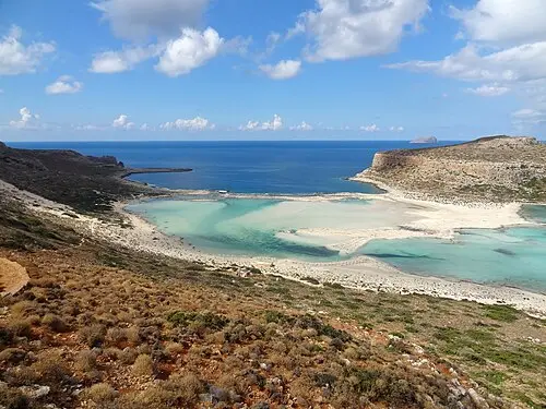
Balos Lagoon
A turquoise lagoon of white and pink sand at the tip of the Gramvousa peninsula. The last 8 km are a rough…

 © Marina Padouva · CC BY-SA 4.0
Elafonisi
Shallow turquoise water and pinkish sand around a small island you can wade to. It is a protected area, so…

 © C messier · CC BY-SA 4.0
Samaria Gorge
A 16 km descent from the Omalos plateau to the Libyan Sea, through the famous Iron Gates. Open roughly May…

 © Dietmar Rabich · CC BY-SA 4.0
Arkadi Monastery
A fortified monastery with a Venetian Baroque façade, a symbol of Cretan resistance since its defenders…

 Photo by Qingqing Cai on Unsplash
Knossos
The largest Minoan palace, partly reconstructed with red columns and copies of its frescoes. Come at…

 © Rigorius · CC BY-SA 4.0
Spinalonga
A Venetian island fortress that served as a leper colony until 1957. Boats run from Plaka, Elounda and…

 © Norbert Nagel · CC BY-SA 3.0
Akrotiri Archaeological Site
A Bronze Age town on Santorini buried by the volcanic eruption of the 16th century BCE, with multi-storey…

 © Olaf Tausch · CC BY 3.0
Fira to Oia Caldera Trail
A walk of roughly 10 km along the caldera rim from Fira through Firostefani and Imerovigli to Oia. The…
Campsites nearby
Trip guides
 © Olaf Tausch · CC BY 3.0
Crete: Chania to Knossos
 © Olaf Tausch · CC BY 3.0
Eastern Crete: Lasithi, Spinalonga and the palm beach of Vai
 © Marina Padouva · CC BY-SA 4.0
Palm beaches, Minoan palaces and windmills – across Crete by camper from Chania to Vai
 © Norbert Nagel · CC BY-SA 3.0