

In-depth guide · CampingSpirit
From the Ontika cliff coast via Sillamäe and Narva into the oil shale country, then on to the hills of Haanja, the Seto villages and the sand caves of Piusa: around 840 kilometres along the EU’s eastern edge, with clear rules for staying close to the Russian border.
The spirit of the route
Eastern Estonia is the counterpart to the pine forests of the north coast: a land of quarries, spoil heaps and borders. Behind the Ontika cliff coast the Valaste waterfall plunges into the Baltic Sea, in Sillamäe Stalinist colonnades stand behind a beach, and in Narva two fortresses stare at each other across the river – one Estonian, one Russian. Further south the hills grow rounder, the lakes deeper and the language more melodic: the Haanja Highlands hold the highest point in the Baltics, in Setomaa women sing polyphonic leelo songs that are part of the intangible world heritage, and at Piusa sand tunnels lead into a bat roost. From your sliding door you will see rapeseed fields, shale heaps, wooden churches and wayside crosses, and in a few places the border fence. This route demands respect for the border and openness to a mix of Estonian, Russian and Seto – and afterwards the evening tea by the lake shore tastes even better.
Stage-by-stage plan
1Stage 1: Tallinn to Toila (Ontika coast) (approx. 195 km)
- The drive
- From Tallinn take the E20 (road 1) eastwards, four lanes in places, then a country road through forest and fields with village crossings and several speed cameras. From Jõhvi head north on minor roads to the coast and follow the Ontika cliff to Toila. A good 3 hours of pure driving time; if you already know the Lahemaa region, you will drive straight through.
- Highlights & must-sees
- Valaste waterfall: at around 30 metres the highest fall in Estonia, with a viewing platform on the edge of the Ontika cliff; strongest in spring and after rain, often frozen in winter.
- Ontika cliff (Baltic Klint): viewpoints along the coast road, a limestone escarpment above the Gulf of Finland.
- Toila-Oru Park: seaside park with castle ruins, steps down to the beach and a view of the Pühajõgi gorge.
- CampingSpirit overnight tip
-
Official campsite or RV park: A campsite called “Toila Spa Kamping” could not be verified: in Toila there is the Toila Spa Hotel, whose offer lists rooms but no pitches. Phone ahead and ask about pitches for motorhomes. As an alternative, consider a farm pitch or a car park at one of the small beaches between Toila and Sillamäe; electricity and service points are not a given here.
Free camping or nature tip (where legal): Everyman’s right allows a short overnight stay on unmarked, unfenced private land outside settlements, but not in municipal car parks or protected areas. The Ontika coast is a protected landscape: stay on the marked paths and do not push into the undergrowth at the edge. RMK camping spots are shown on the map at loodusegakoos.ee.
- Insider tip for campers
- Fill up with fuel and water before Jõhvi; there are filling stations in Ida-Viru, but few with autogas. When the wind blows from the direction of the shale plants, keep windows and roof vents closed.
2Stage 2: Toila to Narva (via Sillamäe and Narva-Jõesuu) (approx. 85 km)
- The drive
- From Toila take the coast road to Sillamäe, then via Vaivara and Auvere to Narva-Jõesuu and upstream along the river to Narva. Good asphalt roads, few gradients, some lorry traffic. Around 1.5 hours of driving, but allow time for walks through the towns.
- Highlights & must-sees
- Sillamäe: a former closed town of the Soviet Union with uranium processing, today an old town in the Soviet classicist style, plus a beach promenade and a town museum.
- Narva-Jõesuu: a wide, fine-sand Baltic beach with 19th-century wooden villas, a spa park and promenade, plus the long dune coast towards the river mouth.
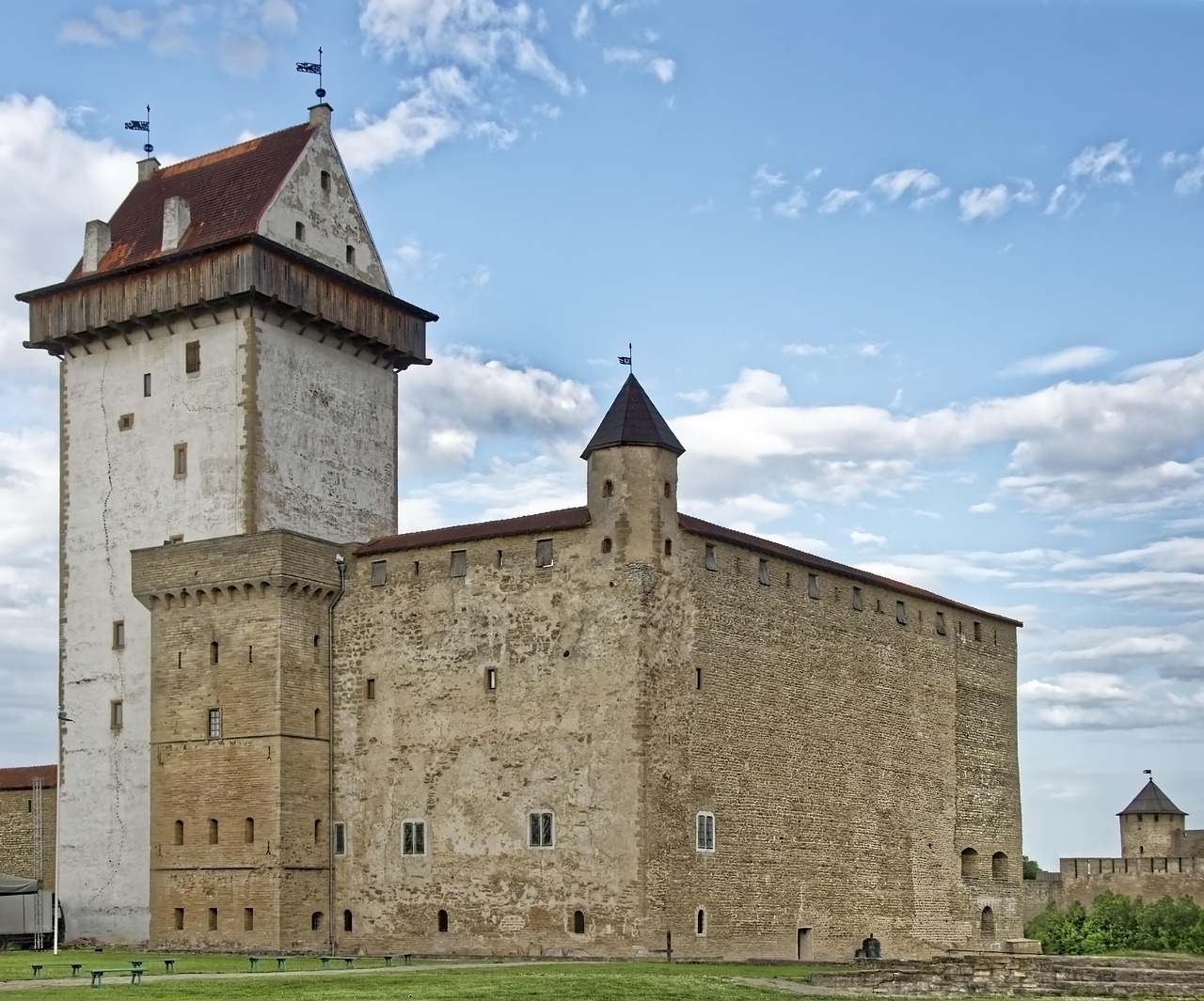
- Narva: Hermann Castle right on the river, the Narva promenade with a view of the Russian fortress of Ivangorod, and the former Kreenholm textile mill on the river island.
- CampingSpirit overnight tip
-
Official campsite or RV park: In the western courtyard of Hermann Castle in Narva there is a caravan park with around ten pitches for motorhomes and caravans and a separate area for tents: electricity, sanitary facilities, fresh water, disposal for cassette and grey water, video surveillance, and the castle gate is closed at night. Ask the museum beforehand about season, opening hours and prices. For Narva-Jõesuu no reliable pitch information is available; ask ahead there as well.
Free camping or nature tip (where legal): In Narva and Narva-Jõesuu wild camping at the border makes no sense; please do not do it: the Narva River is the state border, and the riverside zone is under border control. Stay on the designated promenades and squares, do not enter any barriers and follow the signs “Piiritsoon” or “Piiripunkt”.
- Insider tip for campers
- The road crossing Narva–Ivangorod is closed to vehicles and is not meant for tourism. View Ivangorod Fortress from the promenade and follow the instructions of border guards; out of consideration, you should not photograph border installations or officers. In Narva your phone sometimes connects to Russian networks: switch to manual network selection, otherwise roaming charges threaten.
3Stage 3: Narva to Kohtla-Nõmme (oil shale region, Aidu) (approx. 95 km)
- The drive
- On the E20 back west via Sinimäe to Jõhvi, then country roads to Kohtla-Nõmme and into the area around Kiviõli and Aidu. Between the heaps the route passes slag mountains and open-cast pits; industrial traffic is possible. About 1.5 hours of driving.
- Highlights & must-sees
- Sinimäed (Blue Hills): three hills where heavy fighting took place in 1944; memorials and a museum tell the story.
- Kohtla-Nõmme Mining Park Museum (Kaevanduspark-muuseum): an open-air site with machinery and an underground section of the mining museum; visits and tours need to be arranged in advance, and a helmet and warm clothing are the norm.
- Aidu quarry: a former open-cast oil shale mine with turquoise water, a wind farm and an RMK hiking trail with information boards; the water centre on site rents out canoes, SUPs and pedal boats in the summer season. Whether swimming in the quarry is allowed is not documented; the water in the pit is considered treacherous, so ask on site.
- CampingSpirit overnight tip
-
Official campsite or RV park: Campsites are rare right in the shale region; we could not find a verified pitch here. Check farm and guesthouse pitches around Kohtla-Nõmme and Kiviõli via park4night or Campercontact, or drive on the same day towards Mustvee. Confirm offers by phone in advance.
Free camping or nature tip (where legal): Free camping on industrial land, at spoil heaps and in quarry grounds is not an option because of collapse and storage risks; some older heaps burn from the inside. Respect barriers and warning signs, even if access is still marked on old maps.
- Insider tip for campers
- On the ash heap near Kiviõli there is an adventure centre with a view and activities; check opening hours beforehand, worthwhile in clear weather. The water in Aidu quarry is not suitable as drinking water. For the museum visit bring sturdy footwear and a jacket, even in summer.
4Stage 4: Kohtla-Nõmme / Aidu to Mustvee (Lake Peipus shore) (approx. 110 km)
- The drive
- South via Iisaku and Tudulinna into the Peipus area, finally on low-traffic country roads to Mustvee. The road surface is mostly good, with a few narrow sections and wildlife crossings. A good 2 hours. Lake Peipus is an external border: the eastern shore belongs to Russia.
- Highlights & must-sees
- Mustvee: a port town on the western shore of Lake Peipus, with a population of Russian and Old Believer roots; small harbour, promenade and a view across the wide expanse of water.
- Old Believer villages on the shore (Raja, Kolkja): long street villages, onion growing, prayer houses and the Old Believers’ Museum in Kolkja.
- For Kallaste and the rest of the Peipus shore see the guide “Pine forest, limestone cliffs and windmills – by camper through Estonia to the islands of Saaremaa and Hiiumaa”.
- CampingSpirit overnight tip
-
Official campsite or RV park: We could not find a verified pitch in Mustvee. On the Peipus shore guest farms sometimes rent out pitches, with or without electricity and water; clarify the offer and season in advance.
Free camping or nature tip (where legal): Everyman’s right applies on the lake shore, but not on fenced private land. The lake coast lies in the border area: access to the beach may be restricted by signs; the state border runs across the lake, and boats must not cross it. Check access on site.
- Insider tip for campers
- Onions and smoked fish are sold directly by the roadside; keep cash handy. Leave the drone in the car: in the border area flights are not permitted, or only after agreement with the Border Guard (PPA).
5Stage 5: Mustvee to Võru (approx. 165 km)
- The drive
- From Mustvee on country roads to Tartu (around 85 kilometres), then the well-built road 2 (E263) south via Põlva to Võru. A fast route, with lorry traffic on the main road. Around 2.5 hours of driving time; avoid Tartu at rush hour.
- Highlights & must-sees
- Võru: a small town on Lake Tamula, home of the poet Friedrich Reinhold Kreutzwald (“Kalevipoeg”), with the Kreutzwald Memorial Museum and a lakeside promenade.
- Lake Tamula: bathing spot, swimming jetty and a footpath along the shore.
- St Catherine’s Church in Võru: a Lutheran town church in the classicist style.
- CampingSpirit overnight tip
-
Official campsite or RV park: In and around Võru there are recreation centres and farm pitches on Lake Tamula; we could not find a verified pitch in the town. In the nearby Rõuge area there are caravan sites (see next stage). Confirm electricity and disposal by phone.
Free camping or nature tip (where legal): Everyman’s right applies, but around Võru there are many private farms; ask if in doubt, and keep to the 24-hour limit and a distance from houses. RMK camping spots in Võrumaa are also listed on loodusegakoos.ee.
- Insider tip for campers
- Top up water, food and fuel in Võru; Rimi, Selver and Coop have long opening hours. The Tartu–Võru route is also a main lorry route: plan breaks at car parks with enough space.
6Stage 6: Võru to Haanja, Suur Munamägi and Rõuge (round trip from Võru) (approx. 65 km)
- The drive
- From Võru east into the Haanja Highlands: winding country roads with hills, a few narrow village crossings and some steep ramps. Continue to Suur Munamägi and via Haanja to Rõuge, then back to Võru. About 2 hours of pure driving time, plus hikes.
- Highlights & must-sees
- Suur Munamägi (“Great Egg Hill”): at 318 metres the highest point of the Baltic states; observation tower with a view over forests and lakes (admission).
- Rõuge Suurjärv: Estonia’s deepest lake, at around 38 metres, in the valley of the seven lakes (Ööbikuorg, “Nightingale Valley”); hiking trail, viewpoint, bathing spot.
- Haanja Nature Park: a hilly landscape of forest and lakes with hiking trails and small villages; the visitor centre provides maps.
- CampingSpirit overnight tip
-
Official campsite or RV park: In the Haanja area there are caravan sites: the Tindioru Caravan Park in Rõuge municipality (some electricity, fresh water, registration required; no disposal point is listed) and the Pähni guesthouse in the Haanja-Karula recreation area (motorhome parking, by advance booking only). The RMK camping spot in Haanja, around 300 metres from the car park at Suur Munamägi, is intended only for tents (four at most), with six car spaces at the access road. Ask about access and pitch size in advance; some tracks are narrow or gravel.
Free camping or nature tip (where legal): The nature park has a protection order: camping and fires only at designated places. Motorhomes belong on caravan sites or the car park; wild camping at Suur Munamägi is not usual. Stick to RMK camping and fire sites.
- Insider tip for campers
- The car park at Suur Munamägi fills up around midday on summer weekends: start early. In fog the tower is not worth it. In Rõuge the viewpoint lies above the lake; a circular path leads down to the water.
7Stage 7: Võru to Värska (via Obinitsa, Setomaa) (approx. 70 km)
- The drive
- From Võru east on country roads through Setomaa, past meadows, forest and Seto villages, to Obinitsa and on via Vilo and Lüübnitsa to Värska. Partly narrow asphalt roads and gravel sections, wayside crosses, little traffic. About 1.5 hours. Important: the former shortcut through the Saatse Boot (Saatse saabas) is closed to traffic; some sat navs still know it. Check current detours before you set off.
- Highlights & must-sees
- Obinitsa: the centre of Setomaa, with the Seto Museum, church and village community; Seto leelo, the polyphonic singing, is UNESCO intangible cultural heritage.
- Farm museums and crafts: Seto embroidery, silver jewellery and handicrafts, sometimes by appointment only.
- Värska: a spa town on Pihkva Bay (Lake Pskov), with a mineral water spring, a spa and a lakeside path.
- CampingSpirit overnight tip
-
Official campsite or RV park: In Värska there is the SETO MAN recreation centre (Silla tn 6) with a campsite and caravan park, motorhome parking, sauna and catering; ask about prices, electricity and season in advance. In addition, guesthouses and spa hotels take guests with parking, and in Obinitsa individual farms rent out pitches; confirm details by phone.
Free camping or nature tip (where legal): Setomaa lies in the border area with Russia. Fences, camera masts and warning signs mark the line; the border strip is off limits to civilians. The Saatse Boot (a minor road between Värska and Ulitina, two short sections on Russian territory) was closed by the Border Guard in October 2025 and sealed with concrete blocks; detours have been built or are planned, and construction is under way. The detour via the existing road is around 15 to 20 kilometres. No wild camping near the border, and do not park close to the fence.
- Insider tip for campers
- Petseri Monastery (Pechory) lies on Russian territory, a few kilometres beyond the border: it is not accessible from Estonia, and the Koidula border crossing is not a tourist destination. Do not drive towards the border to see the monastery. Photograph people and services in Seto churches only after asking.
8Stage 8: Värska to Piusa caves (return to Võru) (approx. 55 km)
- The drive
- From Värska on country roads via Obinitsa and Meremäe towards Luhamaa, then to the Piusa gorge. Because of the closure of the Saatse Boot there is no direct way; sat navs may still show old routes, so check your route. After the visit back to Võru or on along road 2 to the north. A good 1 hour of pure driving time.
- Highlights & must-sees
- Piusa caves: a former quartz sand mine with tunnels, today one of the most important bat winter roosts in Northern Europe; visitor centre with a film and a viewing platform.
- Härma walls: sandstone walls in the Piusa ice-age valley with hiking trails along the river bank.
- Piusa ice-age valley hiking trail with bridges, boardwalks and viewpoints; check the length and course on site at the information board.
- CampingSpirit overnight tip
-
Official campsite or RV park: The Piusa Ürgorg recreation centre is a guesthouse with sauna and catering by registration, not a campsite; ask about parking options in advance. Alternatively, stay overnight in Võru and visit Piusa as a day trip.
Free camping or nature tip (where legal): In the Piusa nature reserve the tunnels and slopes are accessible only with a guide and at certain times; in the winter half-year the bats are hibernating and the caves are then closed or only partly accessible. Do not enter the tunnels, do not climb off the paths, and do not climb on barriers.
- Insider tip for campers
- The visitor centre, tours and cave access have seasonal times; check before you travel. Bring a jacket: it stays cool in the tunnels all year round. For the drive back to Tallinn allow around 300 kilometres via Tartu on the E263.
Camping practice & local rules
Wild camping & overnight parking
- Everyman’s right (igaüheõigus): on unmarked, unfenced private land you may stay up to 24 hours, as long as the owner does not forbid it. Keep your distance from houses and do not drive off the paths. In nature reserves the respective protection order applies.
- Border area: along the Russian border (Narva River, Lake Peipus, Lake Pskov, Setomaa) there is a border strip and a border zone with their own access rules. Follow the signs, do not enter fences or barriers, and if in doubt ask the Police and Border Guard Board (PPA). You should not photograph border installations and border officers. Hobby drone flights are not approved in the border zone along the Narva River because of GPS interference; as a rule, leave the drone in the car.
- RMK camping and fire sites (free, not bookable) can be found at loodusegakoos.ee; when forest fire risk is high, open fires are banned there too. In nature parks, protected landscapes and Piusa their own rules apply.
- Apps: RMK map, park4night, Campercontact.
Waste disposal & supplies
- Public service stations are rare in the east; campsites and farms often also accept non-guests for a fee. Never empty a cassette into pit toilets.
- Tap water is drinkable in the towns; RMK sites have no drinking water. In Ida-Viru and Setomaa arrive with full tanks.
- Gas: exchange cylinders from abroad are not accepted. Autogas is available at some filling stations in larger places such as Jõhvi, Narva, Tartu and Võru, hardly at all in the villages. Arrive with full cylinders and an adapter set.
- Cashless payment is possible almost everywhere; in village shops and at markets in Setomaa cash can be useful.
Vehicle size & traffic rules
- Speed limits: 50 km/h in built-up areas, 90 km/h outside, and on some sections in summer up to 100 or 110 km/h. Vehicles over 3.5 t and combinations stay at 90 km/h. Dipped headlights are mandatory all year.
- Tolls: no vignette and no motorway toll for cars and motorhomes up to 3.5 t. Heavy goods vehicles pay tolls; if you have a heavy camper registered as a lorry, check in advance (teetasu.ee).
- Border: the Luhamaa and Koidula crossings are not a destination for tourists and have limited opening hours; Narva is closed to vehicles. Travel to Russia is not an option for EU tourists. Always carry your ID card or passport in the border region; police and border checks are possible. Current opening hours are available from the PPA.
- Navigation and radio: in eastern Estonia GPS interference and false positioning occur; do not rely on the sat nav alone, and take an offline map. Near the border set your phone to manual network selection so that it does not connect to Russian networks.
- Blood alcohol limit 0.2 ‰; mobile phones only with a hands-free kit. Winter tyres are required from 1 December to 1 March. Wildlife crossings (elk, deer), especially at dusk.
- Safety equipment: warning triangle, high-visibility vest and fire extinguisher on board.
CampingSpirit packing & preparation checklist
- Offline maps (RMK, Google Maps offline) and a paper map: GPS interference is well known in eastern Estonia, and the Saatse Boot road is closed to traffic, though sat navs sometimes still lead there.
- ID card or passport for checks in the border area, ideally within reach in the glovebox.
- Warm jacket and sturdy footwear for the museum visit in Kohtla-Nõmme and the cool tunnels of Piusa.
- Mosquito and tick repellent for the lakes and forests in the Haanja Highlands and the Piusa valley.
- Gas adapter set and full cylinders, plus a folding jerrycan for water, because service points are rare in the east.
- Binoculars for birds on the Peipus shore and the far view from Suur Munamägi.
As of 2026-10. Closures, fees and booking rules change: check official sources before you go.