



In-depth guide · CampingSpirit
From the Wuppertal suspension railway via Müngsten, Schloss Burg and the Bergisches Land reservoirs to Altenberg Cathedral, through the Agger valley and via Siegburg into the Siebengebirge: around 285 kilometres of narrow valleys, at the end of which the Drachenfels stands above the Rhine.
The spirit of the route
The Bergisches Land is not a land of wide views but of narrow valleys. The roads dip down to the Wupper, the Dhünn and the Agger, cross rubble-stone bridges and climb back up to farmsteads with black-and-white half-timbering, slate façades and green shutters. In Wuppertal the suspension railway hangs above the river, at Müngsten the railway bridge spans the valley, and in the mornings mist lies on the dark water of the reservoirs. Through the sliding door comes the smell of wet beech leaves; in the afternoon there are waffles, rice pudding and coffee from the Dröppelminna. Further south the hills grow softer, until beyond Siegburg the volcanic domes of the Siebengebirge rise up. At the end the Drachenfels stands above the Rhine, cargo ships glide past below Schloss Drachenburg, and the ferry takes you across to the Rolandsbogen. This route calls for short stages, a low gear and patience in the village through-roads.
Stage-by-stage plan
1Stage 1: Wuppertal to Solingen-Burg (via Müngsten) (approx. 30 km)
- The drive
- Wuppertal stretches a good 15 kilometres along the Wupper valley; the valley axis is heavily used, with lots of traffic lights and lane changes beneath the supports of the suspension railway. Don't drive into the centre – park on the edge and switch to public transport. Then via Cronenberg and down through the wooded Morsbach valley to Müngsten and downstream along the Wupper to Unterburg: steep, winding country roads with few passing places and tight bends around old factory buildings. Pure driving time a good hour.
- Highlights & must-sees
- Schwebebahn (suspension railway): ride the whole line once from Vohwinkel to Oberbarmen, around 13 kilometres in a good half hour, mostly directly above the river – sit at the front of the car.
- Müngsten Bridge: at a good 100 metres high, Germany’s highest railway bridge (1897); in the Brückenpark below, a hand-operated transporter ferry crosses the Wupper.
- Schloss Burg above Unterburg, the rebuilt ancestral castle of the Counts of Berg, with a museum and a view into the Wupper valley.
- CampingSpirit overnight tip
-
Official campsite or RV park: Waldcamping Glüder lies in the Wupper valley near Solingen-Glüder, just a few kilometres from Burg, with electricity and sanitary facilities; ask in advance about transit pitches for motorhomes and length. An alternative is Campingplatz Wersbachtal near Leichlingen-Witzhelden. If you want to spend the night in Wuppertal: the municipal utility designates motorhome pitches at Carnaper Platz in Barmen; check facilities and fees in advance.
Free camping or nature tip (where legal): Wild camping is not permitted in North Rhine-Westphalia outside designated sites. A single night to restore your fitness to drive is tolerated in public car parks without a prohibition sign – without awning, table and chairs. At the Brückenpark and in Unterburg the car parks are small and full during the day; they are not meant for overnight stays.
- Insider tip for campers
- According to the Chamber of Commerce (IHK), Wuppertal has two low-emission zones along the valley axis; you may only enter them with a green sticker, including with foreign number plates. Order the sticker before your trip. In Unterburg the through-road is narrow and parking is scarce. With a large vehicle arrive early, or leave the camper at the site and walk the Wupperweg. Check opening times of the castle and museum, and the operation of the chairlift between Unterburg and the castle, in advance.
2Stage 2: Solingen-Burg to Hückeswagen (Bever reservoir) (approx. 40 km)
- The drive
- From Unterburg steeply up onto the Remscheid heights – first gear and a clear view of oncoming traffic matter more here than the clock. Just pass through Remscheid to Lennep, then east across the Bergisch plateau to the Wupper reservoir at Kräwinklerbrücke and on to Hückeswagen and the Bever. Broad hilltops, hedgerows, rubble-stone farmsteads; in Remscheid and Hückeswagen narrow, steep town streets. Just under an hour’s driving.
- Highlights & must-sees
- Lennep old town with slate-clad town houses and the German Röntgen Museum – Wilhelm Conrad Röntgen was born here.
- Eschbach reservoir near Remscheid, Germany’s first drinking-water reservoir (1891), with a circular path beneath beeches.
- Bever reservoir: a lakeside circular path and bathing spots; in the evening the light lies low over the water.
- CampingSpirit overnight tip
-
Official campsite or RV park: There are several campsites on the Bever reservoir, such as Campingplatz Beverblick with transit pitches for motorhomes and Campingpark Bevertalsperre near Großberghausen. Many pitches are let to seasonal campers; book in summer and at weekends. Hückeswagen also has the Schnabelsmühle and Wupperaue motorhome stopovers – check facilities and fees in advance.
Free camping or nature tip (where legal): The car parks at the reservoirs mostly belong to the Wupperverband water authority or the municipality and serve walkers and bathers. Overnight stays are not intended there, and in many places motorhomes are excluded at night by signs. Drinking-water reservoirs such as the Eschbach reservoir have protection zones with bathing bans and closed shore areas.
- Insider tip for campers
- The Balkantrasse, a surfaced former railway line, starts in Lennep and runs via Wermelskirchen and Burscheid towards Leverkusen – ideal by bike, flat instead of hilly. In Lennep don't drive into the old town; park on the edge. East of the Wupper the Sauerland begins; it is covered by the CampingSpirit guide to the Sauerland and Rothaargebirge.
3Stage 3: Hückeswagen to Kürten (via Wipperfürth and Lindlar) (approx. 40 km)
- The drive
- The valley road follows the Wupper, which up here is still called the Wipper, to Wipperfürth; a detour leads to the Neye reservoir. Then south through meadow valleys and small hamlets to Lindlar and west to Kürten. The minor roads are narrow, some without a centre line, with crests and suddenly tight bends; farm traffic and stone lorries from the Lindlar greywacke quarries are common. A good hour’s driving.
- Highlights & must-sees
- Wipperfürth, considered the oldest town in the Bergisches Land, with the Romanesque parish church of St. Nikolaus on the market square.
- Neye reservoir north of Wipperfürth, a quiet drinking-water reservoir in spruce and beech forest.
- LVR Open-Air Museum Lindlar: rebuilt farmsteads, workshops and gardens from the Bergisches Land, with old breeds of livestock and fields.
- CampingSpirit overnight tip
-
Official campsite or RV park: Wohnmobilpark Kürten offers around 20 motorhome pitches; check electricity, water and waste disposal and fees in advance. For a classic campsite there is Campingpark im Bergischen Land between Lindlar and Wipperfürth. In Wipperfürth the town designates motorhome pitches at the Ohler Wiesen car park.
Free camping or nature tip (where legal): Field and forest tracks are off-limits, even for one evening: they are almost always closed to general traffic, and overnight stays are prohibited in forests and nature reserves. Walkers' car parks on the Neye can be used during the day but are not intended for overnight stays.
- Insider tip for campers
- Allow half a day for the open-air museum, and check opening days and season in advance. For the way from Lindlar to Kürten, don't follow the satnav along single-track farm access roads; take the signposted country roads. Bakeries and farm shops often serve the Bergisch coffee table – waffles, cherries, rice pudding – only at weekends.
4Stage 4: Kürten to Nümbrecht (via Altenberg and the Agger valley) (approx. 75 km)
- The drive
- Over the heights down into the Dhünn valley to Altenberg, then via Odenthal to Bergisch Gladbach and through Bensberg to Overath in the Agger valley. Up the valley via Engelskirchen to Ründeroth and via Wiehl up to Nümbrecht. The section around Bergisch Gladbach is busy; in the Agger valley road, river and railway run close together. Pure driving time about 1.5 to 2 hours.
- Highlights & must-sees
- Altenberg Cathedral: the Gothic Cistercian church in the Dhünn valley with one of the largest church windows in Germany at its west end; today the Catholic and Protestant congregations share it.
- Bergisch Gladbach only briefly: Gottfried Böhm’s town hall in Bensberg or the Alte Dombach paper museum.
- Aggertalhöhle in Ründeroth (municipality of Engelskirchen), a dripstone cave with guided tours; check times in advance.
- CampingSpirit overnight tip
-
Official campsite or RV park: Nümbrecht has a motorhome stopover with a few pitches on the edge of town on Gouvieuxstraße; according to stopover guides there is electricity and fresh water by machine and a grey-water drain, but no cassette disposal – check the current situation in advance. Alternatives are the motorhome stopover at the dripstone cave in Wiehl and the Im Grengel and Am Alten Freibad stopovers in Engelskirchen.
Free camping or nature tip (where legal): The car park at the Altenberger Märchenwald serves cathedral visitors during the day; at weekends it is full, and at night quiet is expressly requested. In the Agger valley many riverbanks lie within nature reserves – no overnight stays, no fires.
- Insider tip for campers
- Come to Altenberg on a weekday morning, when the car park is still free and the cathedral quiet. Don't drive through Bergisch Gladbach in the rush hour. In the cave it is cool and damp even in summer – take a jacket and non-slip shoes.
5Stage 5: Nümbrecht to Königswinter-Oberpleis (via Siegburg) (approx. 55 km)
- The drive
- In the morning to Schloss Homburg, then over the heights of the Homburger Ländchen and via Much and Neunkirchen-Seelscheid down into the Sieg valley to Siegburg. The country roads are wider than in the north, but hilly with long descents. From Siegburg into the hinterland of the Siebengebirge to Oberpleis. A good 1.5 hours’ driving.
- Highlights & must-sees
- Schloss Homburg near Nümbrecht with the museum of the Oberbergischer Kreis and castle garden on a hill spur.
- Michaelsberg in Siegburg: the abbey founded by Archbishop Anno II above the town, with a wide view as far as the Siebengebirge.
- Siegburg old town and market square; Engelbert Humperdinck was born here.
- CampingSpirit overnight tip
-
Official campsite or RV park: Campingpark Siebengebirge near Königswinter-Oberpleis in the hinterland, with electricity, water and waste disposal and sanitary facilities – a good base for the Siebengebirge day. If you want to be closer to the Rhine: in Königswinter-Oberdollendorf there is a simple motorhome spot by the sports ground, free according to stopover guides, for one night, without electricity, water or disposal. The stopover at Königswinter station is repeatedly unusable because of construction work around the station – check the current situation in advance with the Siebengebirge tourist office.
Free camping or nature tip (where legal): The Wahner Heide between Siegburg, Troisdorf and Cologne/Bonn Airport is a large nature reserve with heathland and sand dunes; the walkers' car parks are for day trips, and overnight stays are prohibited there. On the Siegdamm near Hennef there is a walkers' car park that stopover guides list as a motorhome spot; observe the signs on site.
- Insider tip for campers
- Only a narrow access road leads up the Michaelsberg – leave the camper down in town and walk the quarter of an hour. Siegburg is connected by light-rail line 66 to Bonn, Königswinter and Bad Honnef; that saves you looking for parking in the Siebengebirge.
6Stage 6: Königswinter-Oberpleis to Königswinter-Oberpleis (Siebengebirge loop) (approx. 25 km)
- The drive
- A short loop through the Siebengebirge: to the Margarethenhöhe between Königswinter and Ittenbach, down to the Heisterbach monastery ruins and to Königswinter on the Rhine. The roads are steep, winding and at weekends full of day-trippers, cyclists and motorcyclists. The access road to the Petersberg is narrow and winding; with a large vehicle, better go up on foot. Pure driving time under an hour; the day belongs to your legs and the rack railway.
- Highlights & must-sees
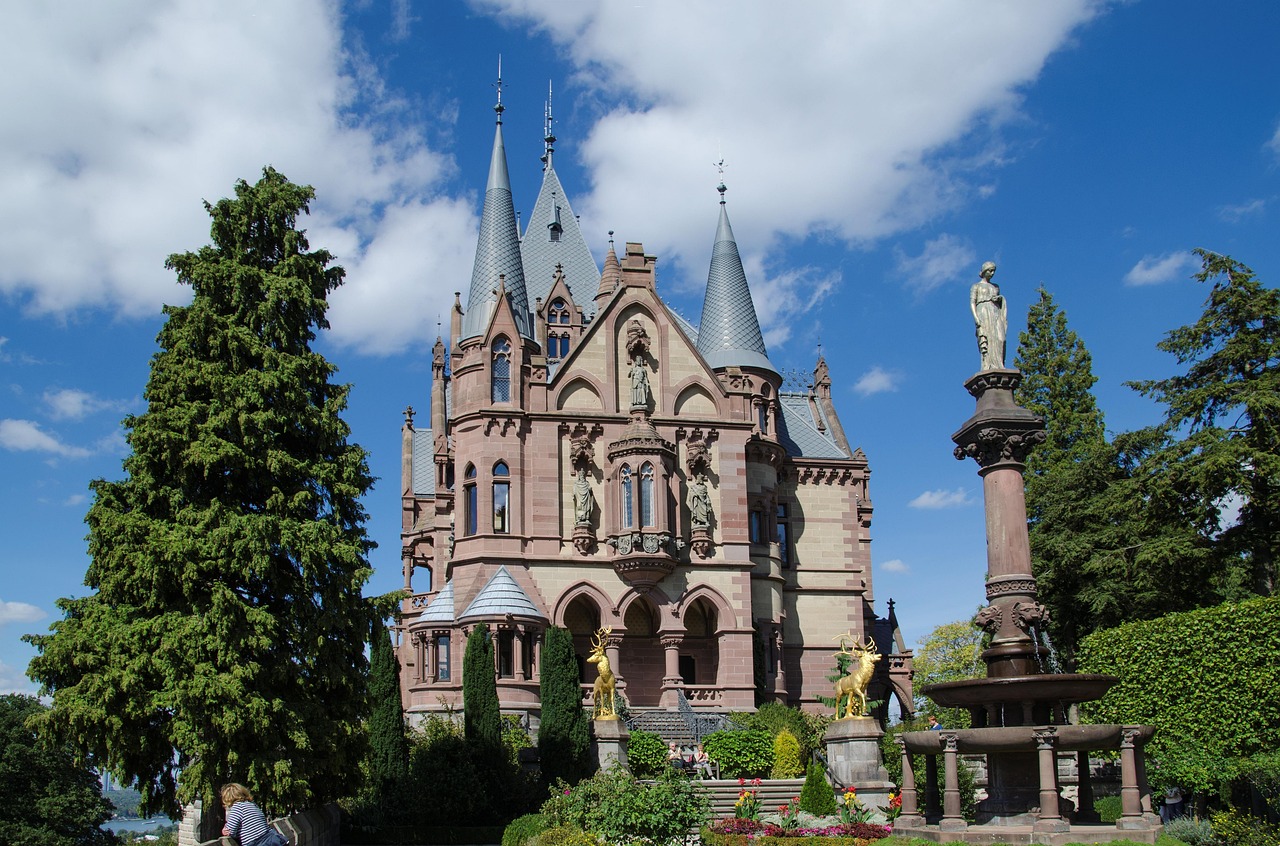
- Drachenfels: up from Königswinter on the Drachenfelsbahn, Germany’s oldest rack railway still in operation (1883); Schloss Drachenburg lies at the middle station, and at the top the castle ruins and the view over the Rhine to Bonn and Cologne.
- Ölberg, at a good 460 metres the highest summit of the Siebengebirge, on foot from the Margarethenhöhe; Heisterbach monastery ruins with the open choir apse in the forest.
- Petersberg with the Guest House of the Federal Republic of Germany – on foot via the old pilgrims' path from Königswinter.
- CampingSpirit overnight tip
-
Official campsite or RV park: Second night at Campingpark Siebengebirge in Oberpleis – it is best to drive the loop without moving camp. Other campsites in the hinterland are Monti’s Camping near Ittenbach and Campingplatz Jillieshof near Aegidienberg.
Free camping or nature tip (where legal): The Siebengebirge is a nature reserve and nature park; overnight stays in walkers' car parks such as the Margarethenhöhe, at Heisterbach and on the Petersberg are not allowed, and paths off the marked routes are closed.
- Insider tip for campers
- In Königswinter old town the streets are narrow and the multi-storey car parks have height restrictions. Park in one of the larger car parks on the edge and walk to the valley station, or come by light-rail line 66 along the Rhine. If you want to walk up the Drachenfels, take the steep Eselsweg and come down by train. Come on a weekday.
7Stage 7: Königswinter to Remagen (via Bad Honnef and the Rhine ferry) (approx. 20 km)
- The drive
- Along the riverside road upstream to Rhöndorf and Bad Honnef, then on the car ferry from Bad Honnef to Rolandseck on the left bank of the Rhine and upstream to Remagen. A flat, well-built route, but with narrow, steep side lanes in Rhöndorf. Allow half an hour of waiting for the ferry and the crossing.
- Highlights & must-sees
- Konrad Adenauer House in Rhöndorf with garden and exhibition about the first Federal Chancellor; his grave lies in the Waldfriedhof cemetery above.
- Grafenwerth island in Bad Honnef, a Rhine island with a riverside path and a view of the Siebengebirge.
- Rolandsbogen above Rolandseck, the last remnant of a castle, with a view of Nonnenwerth island and the Drachenfels; in Remagen the bridge towers with the Peace Museum.
- CampingSpirit overnight tip
-
Official campsite or RV park: Camping Goldene Meile in Remagen on the bank of the Rhine with an adjoining motorhome harbour, electricity, water and waste disposal and sanitary facilities – a finale with a view of the river. On the right bank lie the Wohnmobilstellplatz Siebengebirgsblick in Rheinbreitbach and the Genienau and Rheincamping Siebengebirgsblick campsites near Bad Honnef.
Free camping or nature tip (where legal): Parts of the Rhine banks between Bad Honnef and Remagen are floodplain; gauge boards and closed riverside paths show how quickly the water rises. Overnight stays on the bank are not allowed; clear riverside car parks when the river floods.
- Insider tip for campers
- There is hardly any parking for motorhomes in Rhöndorf – leave the camper in Bad Honnef or Königswinter and take light-rail line 66 to Rhöndorf. The Bad Honnef–Rolandseck ferry runs daily from morning to evening; check the motorhome fare and length limits with the operator. If you are travelling on: the Eifel and the Ahr valley are covered by the CampingSpirit guide to the North Eifel, Ahr valley and Volcanic Eifel, and the Middle Rhine and the Moselle by the guide to the Middle Rhine valley and the Moselle loops.
Camping practice & local rules
Wild camping & overnight parking
- Wild camping is not permitted in North Rhine-Westphalia and Rhineland-Palatinate. A single night to restore your fitness to drive is tolerated in public car parks without a prohibition sign – without awning, table, chairs or lowered stabilisers.
- Forests, nature reserves and nature parks such as the Siebengebirge, the Wahner Heide and the reservoir shores are off-limits. Drinking-water reservoirs have protection zones with bans on bathing and entry; field and forest tracks are closed to motor vehicles.
- Many walkers' and reservoir car parks in the Bergisches Land carry night-time parking bans for motorhomes or height restrictions. Public order offices carry out checks, especially at weekends and at the visitor attractions in the Siebengebirge.
- The legal alternative is the municipal motorhome stopovers found in almost every municipality in the Bergisches Land, as well as campsites with transit pitches. Useful apps and directories: Campercontact, park4night, promobil’s Stellplatz-Radar and the Bordatlas.
Waste disposal & supplies
- Water and waste disposal stations are mainly found at campsites, for example on the Bever reservoir, in the Siebengebirge and in Remagen, and at some larger stopovers. Many small stopovers in the Bergisches Land have only electricity or nothing at all – plan your disposal before two nights at such spots.
- Empty grey water and the cassette only at stations, never into streams, ditches or drains. Many streams feed reservoirs from which drinking water is drawn.
- Tap water in Germany is drinking water; at stopovers use only marked drinking-water taps and your own hose.
- Gas: grey 11 kg exchange bottles are available at petrol stations, DIY stores and camping dealers in the Cologne and Bonn area. LPG filling stations are widespread in the Rhineland; refillable tanks with a German connector can be filled without an adapter.
Vehicle size & traffic rules
- Speed limits: motorhomes up to 3.5 t 50 km/h in built-up areas, 100 km/h outside, recommended speed 130 km/h on the motorway. Over 3.5 t up to 7.5 t 80 km/h outside built-up areas, 100 km/h on the motorway. Car-and-caravan combinations 80 km/h, with Tempo 100 approval 100 km/h on the motorway.
- Low-emission zones: Wuppertal has two low-emission zones along the valley axis, and to our knowledge Cologne and Bonn also have low-emission zones for which you need the green sticker. There are further zones in the Rhineland, for example in Düsseldorf. Check the current situation and boundaries before you travel in the Federal Environment Agency’s register; the sticker also applies to foreign vehicles.
- No motorway tolls and no vignette for motorhomes in Germany. On the Königswinter–Bonn-Mehlem and Bad Honnef–Rolandseck Rhine ferries the motorhome fare depends on vehicle length or weight; check limits with the operator. During floods and extremely low water the ferries may be suspended.
- Old rubble-stone bridges, railway underpasses and village through-roads in the Bergisches Land sometimes have weight and height restrictions – take the signs seriously and set your satnav to your vehicle’s dimensions. Winter tyres are compulsory in snow, ice and slippery conditions (tyres with the Alpine symbol); on the Bergisch heights ice is common in winter.
- If a load projects more than one metre at the rear, it must be marked; if a rear carrier covers lights or the number plate, a light board and a repeat number plate are required. Blood alcohol limit 0.5, 0.0 for novice drivers and under-21s. You may not hold your phone while driving.
CampingSpirit packing & preparation checklist
- Green environmental sticker, ordered before the trip – without it you may enter neither the Wuppertal valley axis nor the Cologne or Bonn low-emission zone.
- Levelling ramps, level 2–3: stopovers in the Bergisches Land are often on slopes or sloping gravel.
- Bikes or e-bikes for the Nordbahntrasse in Wuppertal and the Balkantrasse from Lennep – flat railway paths in a landscape without flat roads.
- Rain jacket and waterproof walking boots: the Bergisches Land is one of the rainiest regions in western Germany, and the paths in the Siebengebirge are steep and slippery after rain.
- Warm jacket for the Aggertalhöhle, which is cool and damp even in high summer.
- Satnav or app with a motorhome profile (height, width, weight), so that you are not routed along single-track farm access roads and under low railway bridges.
As of 2026-10. Closures, fees and booking rules change: check official sources before you go.