

In-depth guide · CampingSpirit
Around 275 kilometres from Bingen up the Nahe to Idar-Oberstein, through Hunsrück-Hochwald National Park to the Erbeskopf and along the Hunsrückhöhenstraße to the Geierlay: an upland loop with vineyards, castles, gem-cutting mills and plenty of forest.
The spirit of the route
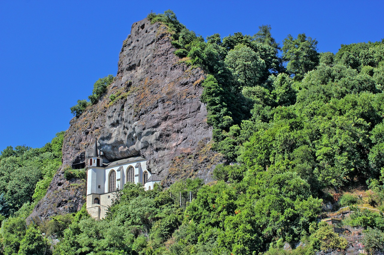
Beyond Bingen, where the Rhine turns north at the Rhine Knee, a quite different landscape begins. The Nahe comes in from the south-west, narrow, greenish-brown, lined with vineyards and red porphyry crags. At Bad Münster am Stein the Rotenfels drops two hundred metres sheer to the river; further upstream a castle ruin sits on every other spur. In Idar-Oberstein a church clings to the rock face, and in old cutting mills the sandstone wheels on which agates were once polished still turn. Then the road climbs onto the Hunsrück: wide plateaus, wind turbines, villages with slate roofs and, in between, the Hochwald, where a national park has been allowed to grow since 2015. Through the sliding door you smell spruce resin and wet leaves; in the evening tawny owls call. The stages are short, the roads quiet – a route for people who would rather hike, look around and stop for a meal than rack up kilometres.
Stage-by-stage plan
1Stage 1: Bingen am Rhein to Bad Münster am Stein-Ebernburg (approx. 30 km)
- The drive
- From Bingen at the Rhine Knee via Bingerbrück into the lower Nahe valley and on country roads via Langenlonsheim, or directly on the B48, to Bad Kreuznach, then along the river into the district of Bad Münster am Stein-Ebernburg. Flat, well-built terrain between vineyards; in Bad Kreuznach itself heavy town traffic and narrow old-town lanes. Pure driving time under an hour, plus the detour up to the Rotenfels.
- Highlights & must-sees
- Bridge houses on the Alte Nahebrücke in Bad Kreuznach – 15th-century houses standing directly on the bridge piers, at their best from the bank in the evening light.
- Rotenfels: a porphyry wall around 200 metres high above the Nahe, often described as the highest cliff between the Alps and Scandinavia; car park up on the plateau near Traisen, with short paths from there to the viewing platforms.
- Salinental with the graduation towers between Bad Kreuznach and Bad Münster, plus the Ebernburg and the Rheingrafenstein castle ruin, which you reach via a small hand-pulled passenger ferry from the spa park into the Huttental and then on foot (ferry runs roughly from Easter to the end of October).
- CampingSpirit overnight tip
-
Official campsite or RV park: Campingplatz Nahe-Alsenz-Eck in Ebernburg, right where the Alsenz flows into the Nahe, with electricity, toilets and showers, and water and waste disposal; within walking distance of the spa park and the ferry. Alternative: Reisemobilstellplatz Salinental at a restaurant in the middle of the graduation-tower grounds, with electricity and waste disposal. Numerous wine estates in the area also offer pitches for guests – ask about places and conditions in advance.
Free camping or nature tip (where legal): Wild camping is not permitted in Rhineland-Palatinate. Under road traffic law, at most a single overnight stay to restore your fitness to drive is tolerated on public car parks where not expressly prohibited – without chairs, awning or extended levelling jacks. The car park at the Rotenfels and the land along the Nahe belong to landscape and nature conservation areas; do not stay overnight there.
- Insider tip for campers
- Bingen serves only as the starting point: fuel up and stock up right there or in Bad Kreuznach, where the big supermarkets are on the edge of town. Avoid Bad Kreuznach town centre with the camper – multi-storey car parks have height restrictions and the old town is tight; better to go into town from the aire on foot or by bike on the Nahe cycle path.
2Stage 2: Bad Münster am Stein-Ebernburg to Kirn (approx. 40 km)
- The drive
- Back via Bad Kreuznach and up the river on the B41 via Waldböckelheim, Bad Sobernheim and Monzingen to Martinstein and Kirn. The B41 is wide and well built; beyond Bad Sobernheim the valley narrows and the vineyards give way to wooded slopes. For Schloss Dhaun, a short climb up into the Dhaun part of Hochstetten-Dhaun; the access road is narrow and steep. About an hour's driving without stops.
- Highlights & must-sees
- Disibodenberg near Odernheim: monastery ruins where Hildegard of Bingen lived for almost four decades, on a wooded ridge above the mouth of the Glan.
- Barefoot trail and the Rhineland-Palatinate Open-Air Museum in Bad Sobernheim – the trail leads through Nahe meadows, clay and a river ford.
- Schloss Dhaun high above the Simmerbach valley and the Kyrburg above Kirn: two extensive castle complexes with views into the Nahe valley and over the Hunsrück slopes.
- CampingSpirit overnight tip
-
Official campsite or RV park: In Kirn there is the very small Wohnmobilstellplatz Schmisserhang on the edge of the old town, with only a few pitches and no services worth mentioning; ask the Kirn tourist information about current conditions. With full service: Campingplatz Papiermühle near Kirn or Campingplatz Haumühle in the Simmerbach valley north-east of the town, both with electricity, toilets and showers, and waste disposal.
Free camping or nature tip (where legal): The trailhead car parks at the Disibodenberg and at the castles are for day parking. Under Rhineland-Palatinate's state forest law, driving and parking motor vehicles on forest tracks and farm tracks is prohibited – even where there is no sign.
- Insider tip for campers
- For the Kyrburg, better to leave the camper down in Kirn and walk up the castle path – the roads up are narrow. Kirn has a long-established private brewery – its beer is found all over the region.
3Stage 3: Kirn to Idar-Oberstein (approx. 20 km)
- The drive
- On the B41 through the narrow Nahe valley via Fischbach to Idar-Oberstein. In Oberstein the main road runs on a deck built directly over the Nahe, and the districts stretch a long way through the main and side valleys. For Idar and the Steinkaulenberg, turn off into the Idarbach valley towards Tiefenstein. A short stage, around half an hour's driving, leaving time for museums and the mine.
- Highlights & must-sees
- Felsenkirche Oberstein: built in the late 15th century into a niche in the rock face above the old town, reached by steps from the market square; above it Schloss Oberstein and the Bosselstein ruin.
- Edelsteinminen Steinkaulenberg: a show mine where agate and jasper were once extracted, with guided tours through the tunnels; on a dedicated digging field visitors can search for stones themselves in fixed time slots.
- Historische Weiherschleife in the Idar valley: a water-powered gem-cutting mill where the cutters lay on their stomachs in front of the large sandstone wheels; plus the Deutsches Edelsteinmuseum in the Idar district.
- CampingSpirit overnight tip
-
Official campsite or RV park: Wohnmobilstellplatz An der Weiherschleife in the Idar valley, just a few minutes from the mill and not far from the Steinkaulenberg, with water and waste disposal. Quieter and with toilets and showers: Campingplatz Harfenmühle near Mörschied with its attached Reisemobilstellplatz Hunsrück, or the Edelsteincamp in Schauren. Check opening times and seasons of the sites in advance.
Free camping or nature tip (where legal): In the tight urban area there is hardly any space for motorhomes apart from the aire; overnight stays on supermarket or museum car parks are not intended. The wooded slopes around Idar-Oberstein are partly within the Saar-Hunsrück Nature Park – the ban on driving on forest tracks applies there.
- Insider tip for campers
- The gemstone mines are only open in season (roughly mid-March to mid-November), and digging runs in fixed time slots – ask the operator in advance about current times and whether booking is required. Bring sturdy shoes and a jacket; inside the mountain it is cool even in summer. The Felsenkirche was closed for years because of rock stabilisation work and has been open to visitors again since 2023, usually only in season; check opening hours before your visit.
4Stage 4: Idar-Oberstein to Otzenhausen (Nonnweiler) (approx. 45 km)
- The drive
- On the B41 further up the Nahe to Birkenfeld and across into Saarland to Nohfelden, then on country roads to Nonnweiler and Otzenhausen on the southern edge of the Hochwald. The Nahe becomes a stream and the landscape opens out into rolling plateaus with pasture and forest. Well built, about an hour's driving.
- Highlights & must-sees
- Celtic ring fort of Otzenhausen (“Hunnenring”) on the Dollberg: the remains of a Celtic fortification of stone ramparts that still stand up to ten metres high today; circular walk of around two hours from the car park at the Keltenpark.
- Keltenpark Otzenhausen at the foot of the hill, with reconstructed houses of a Celtic village.
- The source of the Nahe near Selbach and the Bostalsee near Nohfelden – a large reservoir with swimming spots and a circular path.
- CampingSpirit overnight tip
-
Official campsite or RV park: Womo-Stellplatz Alter Sportplatz in Nonnweiler, simple and quiet on the edge of the village; check facilities in advance. With toilets, showers and electricity: Campingplatz Bostalsee near Nohfelden-Bosen, a large site on the shore, with its own motorhome aire next to it. Book at the Bostalsee in high season.
Free camping or nature tip (where legal): Free camping is not permitted in Saarland either; a single overnight stay for rest on public car parks is at most tolerated, as in Rhineland-Palatinate. The ring fort lies within Hunsrück-Hochwald National Park – do not stay overnight on the car park at the Keltenpark or at the national park entrances.
- Insider tip for campers
- The Saarland villages along the Hochwald are geared to day visitors, but not to campers: use the water and waste disposal at the Bostalsee or in Nonnweiler before you continue into the national park. Fuel is often a little cheaper in Saarland than in Rhineland-Palatinate.
5Stage 5: Otzenhausen to Morbach via the Erbeskopf (approx. 40 km)
- The drive
- Via Hermeskeil north-east on the B327 and up to the Erbeskopf near Hilscheid, then through the Hochwald to Thalfang and Morbach. Wide country roads across the plateau, some bends in the forest and frequent wildlife crossings. The high ground lies at around 600 to 800 metres – fog, wind and, in winter, snow are considerably more frequent here than in the Nahe valley. Around an hour's driving.
- Highlights & must-sees
- Erbeskopf: at 816 metres the highest mountain in Rhineland-Palatinate, with an observation tower and the walk-in sculpture “Windklang”; the Hunsrückhaus at the foot of the mountain is one of the national park gateways, with information about the park.
- Hikes in Hunsrück-Hochwald National Park: scree slopes (Rosselhalden) with quartzite boulders, moors and stream valleys, signposted circular walks from the national park gateways.
- Flugausstellung Hermeskeil, with a large collection of historic aircraft on the edge of town.
- CampingSpirit overnight tip
-
Official campsite or RV park: At the Hunsrückhaus by the Erbeskopf there is a motorhome aire right at the national park gateway – check facilities and season in advance. South of Morbach, in the village of Hoxel, there is a newly built motorhome aire at the Freizeit-Campingplatz, with water and waste disposal and places to eat nearby. Other sites in the area: the Reisemobilstellplatz Thalfang and the Outdoorcampingplatz Massingsmühle near Etgert.
Free camping or nature tip (where legal): In Hunsrück-Hochwald National Park, the state treaty on the national park prohibits putting up tents or other mobile accommodation, camping, lighting fires and parking vehicles outside designated areas; the trailhead car parks at the entrances are for parking, not for overnight stays; rangers patrol the area. At night, stay on the aire at the Hunsrückhaus or at sites outside the park boundary. Forest roads are closed to motor vehicles.
- Insider tip for campers
- Hermeskeil has a motorhome aire on the Labachweg, handy for waste disposal and shopping before the forest. There is skiing on the Erbeskopf in winter; car parks are then full and snow chains or good winter tyres are needed. From Morbach the detour to the Archäologiepark Belginum in Wederath, a Roman settlement on the old trunk road, is worthwhile.
6Stage 6: Morbach to Mörsdorf (Geierlay) (approx. 55 km)
- The drive
- On the Hunsrückhöhenstraße (B327) north-east: built in the late 1930s, this ridge road runs in long, clear straights along the back of the Hunsrück, past wind farms and Hahn Airport near Büchenbeuren, to Kastellaun. From there on country roads to Mörsdorf. Well built and lightly used, with crosswinds on the open sections. A good hour's driving.
- Highlights & must-sees
- Geierlay suspension bridge between Mörsdorf and Sosberg: around 360 metres long and up to 100 metres above the Mörsdorfer Bach valley, open to walkers free of charge since 2015; visitor centre in the village.
- Circular walk across the bridge and back through the valley to Mörsdorf – one of the region's Traumschleifen trails.
- Views across the plateau from the Hunsrückhöhenstraße, on clear days as far as the Eifel.
- CampingSpirit overnight tip
-
Official campsite or RV park: Wohnmobilparkplatz P2 on the Windorfer Straße in Mörsdorf, a partly paved, mixed car park with around 20 spaces for motorhomes and no limit on length of stay: electricity, fresh water and waste disposal are included in the price; there are no showers. Charging by number-plate recognition without a barrier, most recently €20 for the first 12 hours, then €1 per hour or part thereof; payment digitally by card, QR code or app. Check current fees in advance on the official Geierlay website. With toilets and showers: Camping Burgstadt in Kastellaun.
Free camping or nature tip (where legal): Around the bridge there are forest, meadows and a narrow stream valley – only stay overnight on the designated motorhome car park, not on farm or forest tracks or on the streets in the village.
- Insider tip for campers
- From P2 it is a good two to three kilometres on foot to the bridge. Come early in the morning or on a weekday: at weekends and on public holidays the crowds back up on the bridge. The bridge may be closed in storms or icy conditions. For the detour to Burg Eltz: from Mörsdorf it is about 30 kilometres to the car parks on the Maifeld side, then on by shuttle bus or on foot – more on this in the CampingSpirit travel guide to the Rhine and Moselle.
7Stage 7: Mörsdorf to Rheinböllen via Kastellaun and Simmern (approx. 45 km)
- The drive
- Back to Kastellaun, then on country roads to Simmern and on the B50 and further east to Rheinböllen on the edge of the Soonwald. Open plateau with slate villages, pastures and forests; shortly before Rheinböllen the road drops into the Guldenbach valley. Around an hour's driving; the A61 at Rheinböllen takes you back to Bingen in a quarter of an hour.
- Highlights & must-sees
- Kastellaun castle ruin above the old town, with views over the Hunsrück heights.
- Simmern: the Schinderhannesturm, where the robber Johannes Bückler was held prisoner, the Stephanskirche with the tombs of the Counts Palatine, and the Hunsrück-Museum in the Neues Schloss.
- Rheinböllerhütte in the Guldenbach valley, a historic ironworks whose buildings and grounds tell of the industrial history of the Soonwald.
- CampingSpirit overnight tip
-
Official campsite or RV park: Campingplatz An der Pfaffenheck, run by the municipality of Erbach, just a few kilometres from Rheinböllen, with electricity, toilets and showers; ask in advance about waste disposal and season. In Simmern there is a motorhome aire by the Bergschlösschen on the edge of town, and near Simmern also the Höhenhof with camping.
Free camping or nature tip (where legal): The Soonwald is a large, unbroken forest area with nature conservation zones; forest roads and forest car parks are no place to spend the night. No free camping along the Guldenbach.
- Insider tip for campers
- Simmern has a pedestrian zone and narrow lanes around the Schlossplatz – park the camper on the edge of town. Fuel up in Rheinböllen or Simmern before the drive home; prices are higher on the A61. If you have another day, drive back through the Soonwald into the Nahe valley and close the loop via Bad Kreuznach.
Camping practice & local rules
Wild camping & overnight parking
- Wild camping is not permitted in Rhineland-Palatinate or Saarland. Under road traffic law, a single overnight stay to restore your fitness to drive is tolerated on public car parks, provided signs do not prohibit it – without camping behaviour such as a table, chairs, awning or extended levelling jacks.
- Under Rhineland-Palatinate's state forest law, driving and parking on forest tracks is prohibited; this also applies to gravel tracks without a sign. In nature reserves such as at the Rotenfels, overnight stays are strictly off limits, and violations are punished with fines.
- In Hunsrück-Hochwald National Park (Rhineland-Palatinate and Saarland), the state treaty on the national park prohibits putting up tents or other mobile accommodation, camping and lighting fires; overnight stays in a vehicle on trailhead car parks are not intended; use the aires at the national park gateways such as the Hunsrückhaus, or sites in the villages around the edge.
- The region has a dense network of municipal aires and winegrower pitches. Useful apps and directories: Campercontact, park4night, Stellplatz-Radar by promobil, Bordatlas.
Waste disposal & supplies
- Water and waste disposal stations are found at most municipal aires, often operated by coin, card or app; winegrower pitches usually have only fresh water and electricity, and waste disposal is not always available.
- Empty grey water and cassettes only at stations; disposing of them in drains or by the roadside is an administrative offence.
- Tap water in Germany is drinking water; at aires only use taps marked as drinking water.
- Gas: grey 11 kg exchange cylinders are available at many filling stations, DIY stores and camping dealers; LPG stations are widespread, and refillable tanks are filled with the German connector without an adapter.
Vehicle size & traffic rules
- Speed limits: motorhomes up to 3.5 t 50 km/h in built-up areas, 100 km/h outside them, and on the motorway the recommended speed of 130 km/h applies. Over 3.5 t up to 7.5 t, 80 km/h outside built-up areas and 100 km/h on the motorway. Car-and-caravan combinations 80 km/h, 100 km/h on the motorway with Tempo 100 approval.
- No motorway tolls and no vignette for motorhomes. As far as we know there are no low-emission zones along this route; if arriving or leaving via larger cities such as Frankfurt am Main, check the current situation.
- Situational winter tyre requirement in snow, ice and slippery conditions; tyres with the Alpine symbol are valid. On the Hunsrück and at the Erbeskopf, snow and ice are to be expected regularly from November to March.
- Loads overhanging more than one metre at the rear must be marked; if a rear carrier obscures lights or the number plate, a light bar and a repeater number plate are required.
- Blood alcohol limit 0.5, for novice drivers in their probationary period and under 21s 0.0 – save wine tastings on the Nahe until after the stage. Do not hold your phone while driving.
CampingSpirit packing & preparation checklist
- Sturdy hiking boots and poles – the Rotenfels, the ring fort, the Erbeskopf and the Geierlay circular walk lead over rocky paths, roots and steep descents.
- Warm jacket and hat even in summer: it is cool in the gemstone mines, and a cold wind often blows on the Hunsrück heights.
- Small magnifying glass and cloth bag for your own finds when digging at the Steinkaulenberg.
- Bikes for the Nahe cycle path between Bad Kreuznach and Bad Münster and for the Schinderhannes cycle path on the old Hunsrückbahn railway line.
- Card payment and an app for parking fees – the Geierlay car park and many aires charge by number plate, QR code or card.
- Cool box or a compartment for wine boxes: many winegrowers on the Nahe sell direct from the estate, and the pitch often comes with it.
As of 2026-10. Closures, fees and booking rules change: check official sources before you go.