

In-depth guide · CampingSpirit
From Spokane via Steptoe Butte and Palouse Falls to Walla Walla, through the Channeled Scablands to Dry Falls, Grand Coulee Dam and Steamboat Rock, across the Colville Reservation into the Okanogan Valley and on to Lake Chelan: around 1,170 kilometres of dry, wide-open Washington.
The spirit of the route
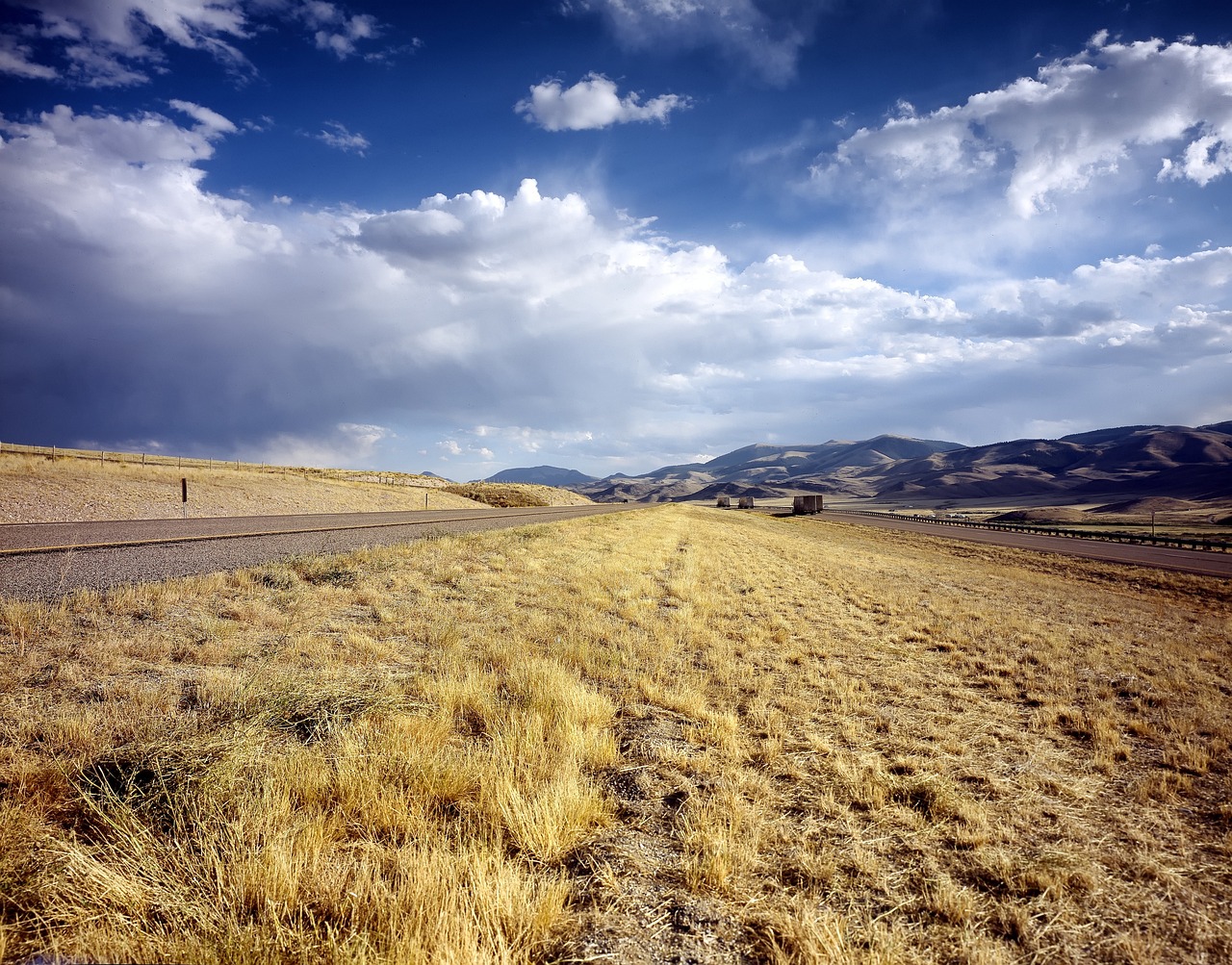
East of the Cascades, Washington tips over: the rainforest and the ferries fall behind, and ahead of the windscreen lies a land of loess, basalt and light. In the Palouse, wheat hills roll to the horizon like a frozen swell, red barns hunker down in the hollows, and from the summit of Steptoe Butte the evening light shows lines of shadow tracing every slope. Further west, the Ice Age ran riot: colossal floods from glacial Lake Missoula tore canyons into the basalt and left behind waterfalls without water and mesas standing in reservoirs. Through the sliding door comes the smell of sage and dry grass, and at night the sky over the coulees is so dark that the Milky Way reaches all the way down to the ground. At the end, everything flows into long, deep-blue Lake Chelan, its slopes lined with orchards and vines.
Stage-by-stage plan
1Stage 1: Spokane to Riverside State Park (approx. 25 km)
- The drive
- Arrival day in eastern Washington’s largest city: from the I-90 into the centre, where the Spokane River crashes right through downtown, then along the river via Downriver Drive and the Aubrey L. White Parkway north-west to Riverside State Park. City traffic, then a narrow, winding riverside road through pine forest; driving time under an hour. Downtown multi-storey car parks are too low for motorhomes – leave large vehicles on the edges of Riverfront Park or in signposted bus parking.
- Highlights & must-sees
- Riverfront Park and Spokane Falls: site of the 1974 World’s Fair, with the steel-cable pavilion, the cable-car gondola over the falls and footbridges right above the rapids. In spring, during snowmelt, the water is at its wildest.
- Spokane River Centennial Trail: paved cycling and walking path along the river from downtown to the Idaho state line and through Riverside State Park – ideal for bikes straight from the campground.
- Bowl and Pitcher: basalt rocks in the river, crossed by a swaying suspension bridge; riverside trails through ponderosa pines.
- CampingSpirit overnight tip
-
Official campsite or RV park: Riverside State Park, Bowl and Pitcher Campground: forest campground right on the Spokane River, mostly standard sites, restroom building with showers, dump station; check when booking whether any sites have hookups, and how many. Reservations through Washington State Parks (washington.goingtocamp.com); check the length limits of individual sites when booking. With a booked site, your vehicle does not need a Discover Pass for this park.
Free camping or nature tip (where legal): In Spokane, sleeping in your vehicle on streets and public land is not allowed, and parks are patrolled. The nearest basic alternative on public land: the Washington DNR’s Dragoon Creek Campground, around 30 kilometres north on the US-395 – primitive, Discover Pass required, for shorter vehicles.
- Insider tip for campers
- Spokane is the last major supply stop for days: fill up with fuel, do a big shop, and sort out spare parts and laundry here. Buy the Discover Pass right at the start (online, at sporting goods shops or in many parks) – you will need it for day visits to state parks, at Steptoe Butte and Palouse Falls, and on DNR and WDFW land.
2Stage 2: Riverside State Park to Palouse (Kamiak Butte) (approx. 150 km)
- The drive
- Take the US-195 south out of Spokane; after the last suburbs, the Palouse opens up. At Steptoe, turn onto Hume Road for Steptoe Butte; check the current state of the access road on the park’s website beforehand. The summit road winds around the hill in a spiral: narrow, with no shoulder and a small car park at the top. Large motorhomes and rigs with trailers should leave the trailer at the bottom or only drive up when the car park is empty. Then on via Colfax and the WA-272 to Palouse. Two-lane country roads, hardly any traffic, slow farm machinery at harvest time.
- Highlights & must-sees
- Steptoe Butte State Park Heritage Site: a quartzite inselberg with its summit at around 1,100 metres, a good 300 metres above the rolling loess hills, and a National Natural Landmark. In the morning and evening, the low-angled light picks out the hills and field patterns most strongly. Day use only until dusk, Discover Pass required; the road is not cleared of snow in winter.
- Colfax: county seat in the valley of the Palouse River, with the Codger Pole, a sculpture of carved logs around 20 metres high honouring a 1938 football game; good for shopping and fuel.
- The small town of Palouse and the back roads to Garfield and Oakesdale: grain silos, wooden barns, brick facades – the classic Palouse motifs lie along the county roads, not the main road.
- CampingSpirit overnight tip
-
Official campsite or RV park: Kamiak Butte County Park (Whitman County) near Palouse: small campground in pine forest at the foot of the butte, a few basic sites without hookups, suitable for short vehicles; check the season and availability with the county. The Pine Ridge Trail leads up to the ridge with views over the Palouse. For large vehicles, head towards the Snake River instead: Boyer Park & Marina, around three kilometres below Lower Granite Dam (owned by the Port of Whitman County), now run as a KOA campground with full and partial hookups, or the small Wawawai County Park on the river.
Free camping or nature tip (where legal): The Palouse is almost entirely private land – wheat, peas, lentils and canola right up to the roadside. Free camping is practically impossible here, and Steptoe Butte is a day-use-only park. Legal basic alternative: the U.S. Army Corps of Engineers riverside areas on the Snake River (for example Illia Landing, Offield Landing or Lambi Creek), primitive, with no drinking water; observe the length-of-stay limits and rules on the signs on site.
- Insider tip for campers
- Photo spots by the fields: only take pictures from public roads and the verge – do not enter farm tracks, driveways or fields, not even “just for a moment”. Never block field entrances – at harvest in high summer, combines and trucks need the full width. Many county roads are gravel, with dust and washboard; with a large camper, stick to paved roads and use the bike for side tracks. The Palouse is green in May and June, golden in July and August.
3Stage 3: Palouse (Kamiak Butte) to Lewis & Clark Trail State Park (approx. 230 km)
- The drive
- Back to Colfax, west on the WA-26 via Dusty and La Crosse to Washtucna, then south on the WA-260 and WA-261 to the Palouse Falls turn-off. The landscape changes from wheat hills to bare basalt and sage. The last 4 kilometres or so of the access road are narrow, winding and partly gravel; the car park fills up quickly in summer and is tight for long rigs. Then on the WA-261 across the Snake River Bridge at Lyons Ferry to Starbuck, and on the US-12 through Dayton to the state park near Waitsburg. Driving time around 3 hours; only a few fuel stations between Colfax and Dayton.
- Highlights & must-sees
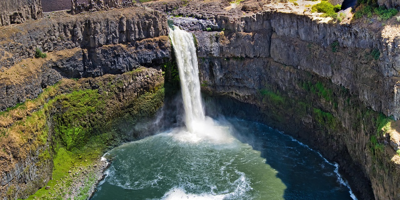
- Palouse Falls State Park: the Palouse River plunges around 60 metres into a bowl of basalt columns – Washington’s official state waterfall since 2014. The viewpoints on the canyon rim are fenced; the paths formerly used to the base and to the upper falls are permanently closed, so always respect the fences. Day use only, Discover Pass required; the former campground is closed, and overnight stays and overnight parking are not allowed.
- Lyons Ferry: confluence of the Palouse and Snake rivers with the striking railway truss bridge (Joso Bridge); nearby was the Marmes Rockshelter, one of the oldest archaeological sites in North America, now flooded by the reservoir.
- Dayton: small town with Washington’s oldest surviving railway depot and the Columbia County Courthouse, the oldest courthouse still in use in the state; behind it rise the Blue Mountains.
- CampingSpirit overnight tip
-
Official campsite or RV park: Lewis & Clark Trail State Park on the US-12 between Dayton and Waitsburg: shady campground in riverside woodland of cottonwoods and ponderosa pines on the Touchet River, basic standard sites, better for shorter vehicles, restroom building. Check the season, hookups and lengths with Washington State Parks. If you would rather stay on the Snake, you will find Army Corps of Engineers sites on the reservoirs, such as Ayer Boat Basin or Little Goose Landing.
Free camping or nature tip (where legal): Around Palouse Falls and Lyons Ferry, overnight stays outside designated sites are prohibited. On Lake Herbert G. West and Lake Bryan (Snake River) there are basic Army Corps of Engineers shoreline areas such as Riparia or Ayer Boat Basin where primitive camping is signposted – with no facilities, and only with consideration for anglers and wildlife.
- Insider tip for campers
- Head for Palouse Falls at sunrise or shortly before the park closes: then the sun sits low in the canyon and there is room in the car park. Rattlesnakes are common on the basalt slopes in summer – stay on the paths and do not reach into rock crevices. Take water for the whole day; the park only has basic toilets.
4Stage 4: Lewis & Clark Trail State Park to Tri-Cities (Burbank) (approx. 125 km)
- The drive
- On the US-12 through Waitsburg to Walla Walla, then further west on the US-12 through wheat, vineyards and onion fields to Wallula and, at the mouth of the Snake River where it meets the Columbia, to Burbank. From Walla Walla mostly four-lane, usually 60 mph; crosswinds at the Columbia gap near Wallula can be unpleasant for high-sided vehicles. Driving time around 1.5 hours without stops.
- Highlights & must-sees
- Walla Walla: small town with a restored Main Street, tasting rooms of more than a hundred wineries in town and the surrounding area, and the sweet Walla Walla onions; the Fort Walla Walla Museum presents pioneer history with a village of historic buildings.
- Whitman Mission National Historic Site west of town: site of the mission of Marcus and Narcissa Whitman, who were killed in an attack by Cayuse in 1847 – a story of the Oregon Trail, epidemics and land seizure that the exhibition tells with nuance.
- Sacajawea Historical State Park near Pasco: here, at the confluence of the Snake and Columbia, the Lewis and Clark expedition camped in October 1805. Day use, Discover Pass required.
- CampingSpirit overnight tip
-
Official campsite or RV park: Hood Park (U.S. Army Corps of Engineers) near Burbank at the mouth of the Snake River: sites with electricity, lawns, showers and dump station, reservations through recreation.gov. Corps alternatives upstream on Lake Sacajawea: Charbonneau Park and Fishhook Park, both with showers and some sites with electricity; check the season dates.
Free camping or nature tip (where legal): There is no legal free-camping option in the greater Tri-Cities area; Hanford Reach National Monument prohibits camping, and the riverside areas in the towns close at night. Fall back on the Corps sites on the Snake River.
- Insider tip for campers
- In summer, the Tri-Cities and Walla Walla often reach 38–40 °C: schedule driving for the mornings, pre-cool the fridge and book sites with shade and electricity for the air conditioning. The bus tours to the B Reactor of the Manhattan Project National Historical Park (the world’s first full-scale reactor) are seasonal and must be booked online in advance; check dates on nps.gov.
5Stage 5: Tri-Cities (Burbank) to Sun Lakes-Dry Falls State Park (approx. 230 km)
- The drive
- Via Pasco north on the US-395 and on the WA-17 through the irrigated land of the Columbia Basin Project: potatoes, maize, hay and fruit, with centre-pivot irrigation and sagebrush steppe in between. Beyond Othello, detours lead into the Columbia National Wildlife Refuge with its basalt channels and lakes. At Moses Lake, cross the I-90 and continue on the WA-17 via Soap Lake into the Lower Grand Coulee, where the basalt walls grow ever higher. Well-built road, 55–60 mph; driving time around 2.5 hours.
- Highlights & must-sees
- Drumheller Channels in the Columbia National Wildlife Refuge: a National Natural Landmark of torn basalt channels, rock islands and ponds – a textbook example of the Channeled Scablands, created by the Ice Age floods. Cranes, geese and ducks in spring and autumn.
- Lake Lenore Caves: short, steep path to rock shelters in the basalt wall of the Lower Grand Coulee, used by people as shelter thousands of years ago; car park on the WA-17.
- Dry Falls: a cliff a good five kilometres wide, over which many times the flow of all of today’s rivers in the world poured during the Ice Age floods. From the viewpoint and the seasonally open Dry Falls Visitor Center, you look out over the lip of the falls and the lakes in the former plunge pool.
- CampingSpirit overnight tip
-
Official campsite or RV park: Sun Lakes-Dry Falls State Park: large campground on Park Lake below the basalt walls, sites with full hookups and without hookups, restroom building with showers, dump station. Reserve in summer through washington.goingtocamp.com. The park also contains a private resort with its own campground. Alternative en route: Potholes State Park on the Potholes Reservoir south-west of Moses Lake.
Free camping or nature tip (where legal): The Washington Department of Fish and Wildlife (WDFW) wildlife areas, such as the Columbia Basin Wildlife Area around the Potholes Reservoir, allow basic camping in many places – with a Discover Pass or WDFW Vehicle Access Pass, according to WDFW for no more than 21 days within 30 days, unless signed otherwise. Overnight stays are prohibited in the Columbia National Wildlife Refuge itself.
- Insider tip for campers
- The Ice Age flood landscape is best explored by bike or kayak: on the lakes in the Dry Falls plunge pool (Deep Lake, Park Lake) the water is warm in summer. Moses Lake has the last big supermarkets before Grand Coulee – stock up here. In the event of wind warnings and dust storms on the basin plain, postpone your drive; visibility can drop to zero.
6Stage 6: Sun Lakes-Dry Falls State Park to Steamboat Rock State Park (approx. 95 km)
- The drive
- Via Coulee City onto the Banks Lake dam and north on the WA-155 through the Upper Grand Coulee: the road runs between the reservoir and sheer basalt walls, past the mesa of Steamboat Rock, to Electric City and Grand Coulee. Well built, but watch for rockfall and wildlife on the road. Around 1 hour to the dam; in the evening, after the laser show, around 25 minutes back to the campground.
- Highlights & must-sees
- Grand Coulee Dam: concrete dam on the Columbia River, completed in 1942, one of the largest hydroelectric plants in the USA; behind it lies Franklin D. Roosevelt Lake. The Bureau of Reclamation visitor centre explains the construction, the irrigation and the consequences for the tribes on the river, whose salmon fishing and villages disappeared. During the summer season, a free laser show is projected onto the dam after dark; check the season, start times and tours on usbr.gov.
- Crown Point Vista above Grand Coulee: viewpoint looking out over the dam, the towns and the start of the reservoir.
- Steamboat Rock: a basalt mesa around 250 metres high rises like a ship out of Banks Lake. A steep path leads up to the plateau with panoramic views over the coulee; Northrup Canyon in the same park is a winter roost for bald eagles.
- CampingSpirit overnight tip
-
Official campsite or RV park: Steamboat Rock State Park: campground on a spit of land in Banks Lake with many full-hookup sites, lawns, a swimming beach, showers and dump station. In summer one of the most sought-after state park campgrounds in Washington – book months ahead through washington.goingtocamp.com. Closer to the dam: Spring Canyon Campground in Lake Roosevelt National Recreation Area (NPS), without hookups, with drinking water and dump station, reservations through recreation.gov.
Free camping or nature tip (where legal): The WDFW’s Banks Lake Wildlife Area has basic, signposted camping areas on the shore at several spots; Discover Pass or WDFW Vehicle Access Pass required, no facilities. Overnight stays are not allowed at the viewpoints by the dam or in the towns.
- Insider tip for campers
- The laser show only starts once it is fully dark, so late in June – either book a night at Spring Canyon or drive back to Steamboat Rock very slowly because of wildlife. A strong wind often blows on Banks Lake in the afternoon: retract the awning and plan kayak trips for the morning.
7Stage 7: Steamboat Rock State Park to Conconully State Park (approx. 175 km)
- The drive
- Back via Grand Coulee and north on the WA-155 into the Colville Reservation: via Nespelem and Disautel Pass, a two-lane mountain road through pine forest and open slopes, then down into the Okanogan Valley to Omak. From Okanogan, take Conconully Road north-west into the mountains. Driving time around 3 hours; fuel in Grand Coulee, Nespelem (limited), Omak and Okanogan. Expect ice and wildlife on the pass in autumn and spring.
- Highlights & must-sees
- Nespelem: main community of the Confederated Tribes of the Colville Reservation; Chief Joseph of the Nez Perce, who died here in exile, is buried in the small cemetery. A place of remembrance – quiet, respectful, no drones.
- Omak and Okanogan: towns on the Okanogan River with orchards and cattle country; the Omak Stampede with its controversial Suicide Race takes place every August. The Okanogan County Historical Museum in Okanogan tells of mining, settlers and cattle drives.
- Conconully: former gold-rush town between two lakes, surrounded by the Okanogan-Wenatchee National Forest; starting point for forest roads and hikes.
- CampingSpirit overnight tip
-
Official campsite or RV park: Conconully State Park on Conconully Reservoir: grassy and wooded sites by the water, standard sites, sites with partial hookups and, on the upper lake, some with full hookups, restroom building with showers, dump station (fee). Open only in the summer half of the year, closed in winter. Reservations through washington.goingtocamp.com. In the surrounding area there are also small Forest Service campgrounds, mostly without hookups and with short pads.
Free camping or nature tip (where legal): Dispersed camping is permitted in the Okanogan-Wenatchee National Forest around Conconully, generally for up to 14 days in one spot and well back from the shore; forest roads are often steep and unpaved. Further north, towards Loomis, the WDFW’s Sinlahekin Wildlife Area offers basic camping areas (Discover Pass). On the Colville Reservation, camping, fishing and hunting by non-members are only permitted with the tribes’ permission – do not simply stop by lakes or rivers along the way.
- Insider tip for campers
- In high summer, the Okanogan is one of the most wildfire-prone regions in the USA – major fires such as the Carlton Complex in 2014 and the Okanogan Complex in 2015 devastated entire valleys here. Before setting off, check InciWeb, WSDOT and the Forest Service and DNR fire restrictions; avoid sparks: do not let chains drag, do not park on dry grass, and only run the generator on gravel.
8Stage 8: Conconully State Park to Lake Chelan State Park (approx. 140 km)
- The drive
- Back to Okanogan and south on the US-97 along the Okanogan River via Malott and Brewster to the Columbia; at Pateros the Methow flows in. Continue south on the US-97 along the Columbia and, just before the Beebe Bridge, take the US-97A up to Chelan, then follow South Lakeshore Road along the south shore of the lake to the state park. Well-built highway, winding lakeside road from Chelan. Driving time around 2 hours.
- Highlights & must-sees
- Confluence of the Okanogan and Columbia at Brewster and Pateros: terraced orchards, roadside apple stands, harvest time in autumn.
- Chelan: the town at the southern end of the glacial lake, around 80 kilometres long and more than 450 metres deep, with Riverwalk Park at the lake’s outlet, beach parks and Lake Chelan AVA wineries on the slopes.
- Lady of the Lake: passenger boat from Chelan and Fields Point Landing to Stehekin at the northern end of the lake, which can only be reached by boat, floatplane or on foot – a day trip without the camper.
- CampingSpirit overnight tip
-
Official campsite or RV park: Lake Chelan State Park on the south shore: grassy and tree-shaded sites right on the lake, sites with and without hookups, swimming beach, dock, showers, dump station; booked out long in advance in summer. Further up the lake at the end of South Lakeshore Road: Twenty-Five Mile Creek State Park with a marina and hookup sites. On the Columbia between Chelan Falls and Orondo, the Chelan PUD’s Beebe Bridge Park is an alternative.
Free camping or nature tip (where legal): In Chelan and Manson, overnight stays on the shore, in beach parks and on streets are not allowed. Above the lake, dispersed camping is possible in the Okanogan-Wenatchee National Forest, but the forest roads (such as the access towards Snowberry Bowl and Shady Pass) are steep, narrow and unsuitable for large vehicles; areas are closed in fire summers.
- Insider tip for campers
- The lakeshore is private almost everywhere; public swimming spots are the state parks and the municipal parks in Chelan and Manson. At weekends in July and August, boats and cars back up – arrive midweek. If you are continuing west over the North Cascades, you will find the connecting route from Pateros in our travel guide to the North Cascades Highway and Methow Valley.
Camping practice & local rules
Wild camping & overnight parking
- Washington has no general right to free camping. Dispersed camping is legal in the Okanogan-Wenatchee National Forest (usually up to 14 days), on much Washington DNR land and in the WDFW wildlife areas, in each case only where it is not expressly prohibited. A Discover Pass (or the WDFW Vehicle Access Pass with a hunting/fishing licence) is mandatory on DNR and WDFW land.
- The Palouse and the irrigated land are almost entirely private land. Farm tracks, driveways and stubble fields are off-limits – and that includes photo stops. Anyone parked on farmland without permission risks being charged with trespassing.
- Towns such as Spokane, Walla Walla, the Tri-Cities and Chelan prohibit sleeping in vehicles on streets and in parks; state parks such as Steptoe Butte and Palouse Falls are day-use-only parks and close at dusk.
- Reservations: Washington State Parks through washington.goingtocamp.com, Army Corps of Engineers sites and Lake Roosevelt National Recreation Area through recreation.gov. Steamboat Rock, Sun Lakes and Lake Chelan book up early in summer.
- Colville Reservation (WA-155 between Grand Coulee and Omak): tribal land with its own sovereignty; camping, fishing and hunting by non-members only with tribal permission. Do not enter sacred sites or burial grounds.
- Federal lands: since 2026, some US national parks charge higher fees and surcharges for visitors without US residency; check current amounts on nps.gov. The NPS sites on this route (Lake Roosevelt, Whitman Mission, Manhattan Project) are not among the affected national parks; the main charges there are camping and boating fees.
- Apps and websites: iOverlander, Campendium, The Dyrt, Recreation.gov, WSDOT (road conditions), InciWeb and the DNR wildfire map; Park4Night is hardly used here.
Waste disposal & supplies
- Dump stations at almost all state parks on the route (Riverside, Sun Lakes-Dry Falls, Steamboat Rock, Conconully, Lake Chelan) and at Corps sites such as Hood Park; some fuel stations and truck stops on the I-90 and US-395 offer them for a fee.
- Drinking water: tap water is drinkable; there are no water points between Colfax and Dayton, on the Colville Reservation or on WDFW land – always set off with a full tank. Expect considerably higher consumption in summer.
- Empty grey water and chemical toilets only at dump stations; draining onto the ground or into water is prohibited and penalised in state parks.
- Propane: fuel stations, DIY stores and farm supply stores fill US cylinders that meet DOT standards; European cylinders are generally not filled. Rental motorhomes have built-in tanks.
- Electricity: hookup sites offer 30, sometimes 50 A at 120 V. During heatwaves, hookup sites go quickly because of air conditioning.
- Supplies: large supermarkets in Spokane, Pullman, Walla Walla, the Tri-Cities, Moses Lake, Omak and Chelan; only small shops in between. Fuel stations are few and far between in the Palouse and on the reservation.
Vehicle size & traffic rules
- Speed limits: up to 70 mph on interstates in eastern Washington, usually 55–60 mph on highways, 25–35 mph in towns. Vehicles towing trailers and heavy vehicles over 10,000 pounds may drive no faster than 60 mph.
- Phones at the wheel only hands-free; even holding the phone is an offence. For emergency vehicles at the roadside, the Move Over law applies: change lanes or slow down considerably.
- Discover Pass: mandatory for vehicles in Washington State Parks (day use) and on DNR and WDFW land. The annual pass costs 45 USD, the day pass 10 USD (plus transaction fees); one pass can be used for two vehicles but is only valid for one at a time. With a booked campsite in a state park, you do not need it there for the days of your stay.
- No tolls on the entire route. Legal maximum height 14 ft (4.27 m); watch for viaducts and multi-storey car parks in Spokane. Many state park sites are shorter than 40 ft, and the summit road on Steptoe Butte is narrow and not intended for long rigs.
- Wildfire season roughly July to October: during this period, burn bans are regularly in force in state parks, on DNR land and in the national forest; wood fires are often prohibited even in fire rings, while propane is usually allowed. Smoke can affect the air for weeks – check air quality on AirNow and the Washington Smoke Blog, and heed county evacuation levels.
- Harvest time July to August: combines, trucks and wide farm machinery on country roads, often slow and turning without warning; only overtake when you can see ahead. Stone chips and dust on gravel roads.
- Wildlife: mule deer and white-tailed deer cross especially at dusk, frequently on the WA-155 and US-97. Rattlesnakes on basalt slopes from Palouse Falls to Steamboat Rock. Emergency number 911; mobile coverage is patchy in the coulees, on the reservation and in the mountains around Conconully.
CampingSpirit packing & preparation checklist
- Telephoto lens (at least 200 mm) and polarising filter: the typical Palouse shots are taken from the roadside and from Steptoe Butte with a long focal length – you do not walk into fields for them.
- Discover Pass (annual pass) visible on the rear-view mirror: needed at almost every stop on the route, from Steptoe Butte and Palouse Falls to the WDFW land at Banks Lake.
- FFP2 masks and a small air purifier with a 12 V or shore power connection: in fire summers, smoke hangs over the Okanogan, the coulees and Chelan for days.
- Reflective window covers, a sunshade and 20 litres of reserve water: in the Columbia Basin, 38 °C and above is normal in summer, and shade is scarce.
- Fire extinguisher, folding spade and a bucket: essential for responsible camping in the dry national forest and on WDFW land.
- Sturdy hiking boots and long trousers: for the basalt scree at Steamboat Rock and Lake Lenore Caves, and as protection against rattlesnakes and thorns in the sage.
As of 2026-10. Closures, fees and booking rules change: check official sources before you go.