

In-depth guide · CampingSpirit
From Auckland via the Coromandel Peninsula, the thermal fields of Rotorua and Lake Taupō to Tongariro National Park and over the Desert Road to Ōhakune: around 840 kilometres of driving on the left between hot sand, sulphur steam and volcanic ash.
The spirit of the route
This route begins in the salt wind and ends in thin mountain air. On the Coromandel, pōhutukawa trees tip over the bays in red bloom, the road clings to the Firth of Thames coast in tight bends, and on the east coast people dig holes in the sand at low tide that fill with hot water. Beyond Waihī the land opens out wide and green, then suddenly smells of rotten eggs: Rotorua steams from drains, parks and front gardens, and mud pools bubble next to the playground. South of Lake Taupō the three volcanoes Tongariro, Ngāuruhoe and Ruapehu rise out of the tussock – from the sliding door you see the perfect cone of Ngāuruhoe in the morning and the snowy flank of Ruapehu in the last light of the evening. Travelling here, you live by the tide table, the volcanic alert level and the mountain forecast, spend your nights at holiday parks and DOC campsites, and quickly learn that a green warrant in the window is worth more than any shortcut.
Stage-by-stage plan
1Stage 1: Auckland to Coromandel (approx. 170 km)
- The drive
- Leave Auckland heading south on the SH1 motorway, turn onto SH2 at Bombay and cross the flat Hauraki Plains to Thames – a good 115 kilometres, around 1.5 hours. From Thames, SH25 follows the west coast of the peninsula: around 55 kilometres of narrow, winding shore road right on the Firth of Thames, with one-lane bridges, rockfall spots and hardly any chances to overtake; allow about an hour for it. On the last section the road climbs over a saddle with views of Coromandel Harbour.
- Highlights & must-sees
- Thames: the old gold-mining town with the Thames School of Mines and the Goldmine Experience; starting point for the Kauaeranga Valley and the Pinnacles track (a long day hike or an overnight trip with a stay in the DOC hut).
- The shore road between Tapu and Coromandel: fringes of pōhutukawa, small gravel beaches and pull-off bays; when the trees flower around Christmas the whole coast glows red.
- Driving Creek in Coromandel: the narrow-gauge mountain railway through regenerating kauri forest, built by the potter Barry Brickell.
- CampingSpirit overnight tip
-
Official campsite or RV park: Coromandel Top 10 Holiday Park on the northern edge of town, within walking distance of the centre, with powered sites, toilets and showers, kitchen and dump station. Quieter, by the water, is Long Bay Motor Camp west of town. If you stop in Thames: Dickson Holiday Park in the north of town; in the Kauaeranga Valley DOC runs several basic campsites with toilets.
Free camping or nature tip (where legal): The Thames-Coromandel District regulates freedom camping through a bylaw: on council land only in a certified self-contained vehicle (green warrant) and only where it is not expressly prohibited; at many beach car parks, in town centres and during the summer holidays bans or extra conditions apply. Check the current map of permitted and prohibited areas on the council website or in CamperMate.
- Insider tip for campers
- Fill up and shop in Thames – supplies on the peninsula are more expensive and sparser. The Coromandel roads have been damaged by storms several times in recent years: after the storm in January 2026 several sections of SH25 were closed, including Coromandel–Whitianga, and SH25A between Kōpū and Hikuai was also cut by slips for a time; repairs brought full closures and single-lane sections with traffic lights or stop/go for weeks afterwards. Check the status on the NZTA Journeys page before each stage.
2Stage 2: Coromandel to Hāhei (approx. 85 km)
- The drive
- From Coromandel, SH25 winds east over the ranges, past Kūaotunu and Matarangi, to Whitianga (around 45 kilometres, just under an hour) and then along Whitianga Harbour via Coroglen and Whenuakite to Hāhei. The shorter 309 Road through the bush is partly unsealed, narrow and repeatedly affected by slips after heavy rain; for motorhomes SH25 is the sensible choice.
- Highlights & must-sees
- Kūaotunu and Otama Beach: wide, barely developed beaches right on or just off SH25 – a good swimming stop.
- Whitianga: harbour and waterfront; the passenger ferry to Ferry Landing takes pedestrians and cyclists to the south side in a few minutes, for Shakespeare Cliff Lookout.
- Te Whanganui-A-Hei Marine Reserve near Hāhei: snorkelling in Gemstone Bay, kayak trips to the rocky cove.
- CampingSpirit overnight tip
-
Official campsite or RV park: Hahei Holiday Resort right behind the beach at Hāhei, with powered sites, toilets and showers and kitchen; book early for the summer holidays. Alternatively, Hot Water Beach Top 10 Holiday Park a few kilometres south, which is also well placed for the next stage.
Free camping or nature tip (where legal): Hāhei and Hot Water Beach are among the busiest spots on the peninsula; overnight stays in beach and visitor car parks are not allowed here and are enforced in summer. Freedom camping with a green warrant only on expressly designated council sites, which are often restricted in peak season.
- Insider tip for campers
- Cathedral Cove: the car park at the top of Grange Road is now permanently a drop-off and pick-up zone only, and parking is banned on Grange Road itself. Leave motorhomes in the large council visitor car park at the entrance to Hāhei or in the paid car park on the Cathedral Cove Gateway Trail (Lees Road), then walk or take the shuttle to the track. The track reopened in December 2024 after storm damage; after heavy rain, renewed closures and rockfalls are possible: don’t linger under the rock arch, and don’t go during or after heavy rain; there are neither toilets nor water at the beach. Check the current status with DOC.
3Stage 3: Hāhei to Waihī (approx. 100 km)
- The drive
- A short hop to Hot Water Beach, then back onto SH25 and over a pass down to Tairua. South of there the road swings between coast and hills via Whangamatā and Whiritoa to Waihī – well built, but winding and busy on summer weekends; driving time around two hours.
- Highlights & must-sees
- Hot Water Beach: for around two hours either side of low tide, hot water bubbles up through the sand at the southern end of the beach; bring a spade or hire one on site. Note: the beach has strong rip currents and is considered one of the most dangerous swimming beaches on the peninsula.
- Paku Summit in Tairua: a short, steep climb up the old volcanic cone with views over the harbour and Pauanui.
- Waihī: the Martha Mine with the walkway around the rim of the open-pit gold mine in the middle of town; to the east, Waihī Beach with its long sandy beach.
- CampingSpirit overnight tip
-
Official campsite or RV park: Waihi Beach Top 10 Holiday Resort on the beach at Waihī Beach, around ten kilometres from town, with powered sites, toilets and showers and dump station. Quieter, at the southern end, is Bowentown Beach Holiday Park with views of the harbour entrance.
Free camping or nature tip (where legal): Whangamatā and Waihī Beach also heavily restrict freedom camping in summer; Waihī Beach already belongs to the Western Bay of Plenty District with its own bylaw. Use only designated sites with a green warrant and follow the signs at the entrances.
- Insider tip for campers
- Check the tide table for Hot Water Beach (MetService or LINZ) the evening before and come early or late – at the best low tides in summer the car parks are full; check parking rules and any fees on the signs. Afterwards, knock the sand out of shoes and spade before it ends up in the van; outdoor showers at the beach are limited.
4Stage 4: Waihī to Rotorua (approx. 130 km)
- The drive
- Take SH2 south along the Bay of Plenty towards Tauranga, through kiwifruit orchards, then via Te Puke and inland on SH33 to Rotorua. Around two hours. Around Tauranga there are two toll roads (Takitimu Drive Toll Road and Tauranga Eastern Link); to avoid them, follow the signposted toll-free alternative along the old roads through town.
- Highlights & must-sees
- Mauao (Mount Maunganui): the volcanic cone at the entrance to Tauranga Harbour, with a summit track and a base track; motorhome parking nearby is scarce, so come early.
- Okere Falls on SH33: a short walk to the falls of the Kaituna River, where rafts go over a seven-metre waterfall.
- Kuirau Park in Rotorua: a free public park with steaming ponds, mud pools and foot baths in the middle of town.
- CampingSpirit overnight tip
-
Official campsite or RV park: Rotorua Thermal Holiday Park on the southern edge of town, with powered sites, toilets and showers, dump station and its own thermal pools. Quieter and closer to nature: Blue Lake Top 10 Holiday Park on Lake Tikitapu, around 10 kilometres south-east.
Free camping or nature tip (where legal): Rotorua Lakes Council allows freedom camping in parks and reserves only on a few designated, marked sites: free and only for certified self-contained vehicles at places such as the Government Gardens, Hamurana Reserve and Trout Pool Reserve near Okere Falls, and for a fee also for other vehicles at some lakes outside town. A maximum of two consecutive nights per calendar month per site, no bookings, few spaces; overnight stays are prohibited in all other parks and reserves. Check the current map on the council website and otherwise use a holiday park.
- Insider tip for campers
- The Tauranga toll roads have no barriers: number plates are recorded by camera, and you pay online with NZTA no later than five days after travelling, otherwise fees and reminders are added via the rental company. In Rotorua, keep strictly to the paths in the signposted geothermal areas: the ground can be thin and boiling hot underneath.
5Stage 5: Rotorua to Taupō (approx. 90 km)
- The drive
- Take SH5 south through pine forests and across the Volcanic Plateau; after around 30 kilometres turn off to the Wai-O-Tapu thermal area, then continue on SH5 to Taupō. Wide and well built, a good hour of driving time; with the thermal parks, a full day. Just before Taupō the access road to Huka Falls branches off.
- Highlights & must-sees
- Te Puia in Rotorua (before you leave): the Whakarewarewa valley with Pōhutu Geyser, mud pools, the kiwi house and the Māori arts and crafts institute.
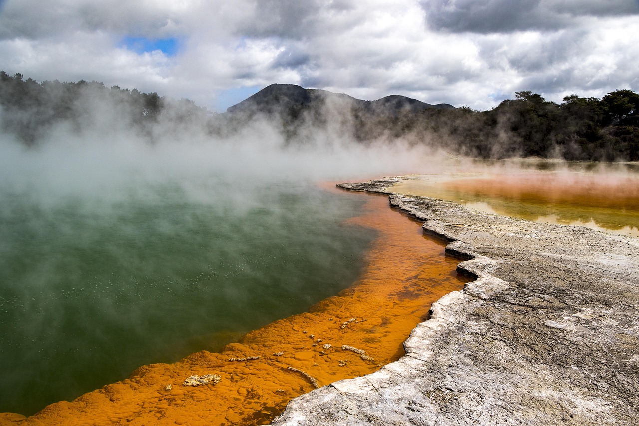
- Wai-O-Tapu Thermal Wonderland: the orange-rimmed Champagne Pool, the lurid green Devil’s Bath and Lady Knox Geyser, which is set off at a fixed time every morning – be there early.
- Huka Falls: the Waikato River forces its way through a narrow rock channel; nearby are the Aratiatia Rapids, where the dam is opened several times a day (check times in advance), and the Craters of the Moon thermal field.
- CampingSpirit overnight tip
-
Official campsite or RV park: Lake Taupo Top 10 Holiday Resort in the east of town with powered sites, toilets and showers and dump station. Taupō DeBretts Spa Resort on the road to Napier combines pitches with hot thermal pools.
Free camping or nature tip (where legal): Taupō District Council designates Reid’s Farm (Hipapatua Reserve) on the Waikato River north of town as a freedom camping site for non-self-contained vehicles; certified self-contained vehicles are expected to use other council land outside reserves and prohibited zones instead. A maximum of three nights applies to everyone. Conditions change occasionally – check the council map and the signs on site.
- Insider tip for campers
- Natural hot streams such as Kerosene Creek are tempting, but the amoeba Naegleria fowleri can occur in geothermal water in New Zealand – never put your head under the water. At thermal parks, also note: in hollows and when there is no wind, hydrogen sulphide can reach dangerous concentrations, so hold children by the hand.
6Stage 6: Taupō to Whakapapa (approx. 100 km)
- The drive
- Take SH1 south along the eastern shore of Lake Taupō to Tūrangi, around 50 kilometres with lake views, then SH41 and SH47 past Lake Rotoaira and beneath Tongariro, and up SH48 to Whakapapa Village at around 1,100 metres. A good two hours; the last few kilometres climb noticeably.
- Highlights & must-sees
- Tongariro National Trout Centre near Tūrangi: underwater viewing chamber on the Waihukahuka Stream.
- Tokaanu Thermal Pools at the south-western end of the lake: simple thermal pools for tired legs; check whether they are open beforehand.
- Taranaki Falls Walk from Whakapapa: a loop through tussock and mountain forest to a waterfall over a lava step, with views of Ruapehu and Ngāuruhoe.
- CampingSpirit overnight tip
-
Official campsite or RV park: Whakapapa Holiday Park in Whakapapa village, with powered sites, toilets and showers and kitchen – the only fully equipped site in the middle of the national park. Simpler and quieter: the DOC Mangahuia Campsite on SH47 with toilets and stream water (boil it), no power.
Free camping or nature tip (where legal): In Tongariro National Park overnight stays are only allowed at the designated DOC campsites and the holiday park; they are prohibited at trailhead car parks, on roadsides and at the Crossing car parks. DOC campsites are charged by category, some with online booking; check fees on doc.govt.nz.
- Insider tip for campers
- The last reliable fuel stop before the plateau is Tūrangi; there is also a petrol station in National Park Village, but not in Whakapapa. On the plateau it can freeze at night even in summer, and the weather can switch from sun to hail within an hour.
7Stage 7: Whakapapa to Whakapapa (Tongariro Alpine Crossing) (approx. 30 km)
- The drive
- This day belongs to the hike, not the road: the Tongariro Alpine Crossing is a one-way track of around 19 kilometres from Mangatepōpō across the Red Crater plateau and past the Emerald Lakes to Ketetahi, which takes you six to eight hours. With the campervan you only drive to the shuttle departure point in Whakapapa or National Park Village and come back in the evening.
- Highlights & must-sees
- Red Crater: the highest point of the Crossing, with rust-red crater walls and steaming vents.
- Emerald Lakes: three turquoise-green crater lakes right below the ridge – sacred to the local iwi, so neither swim in them nor touch them.
- View of the Ngāuruhoe cone from South Crater; climbing to the summit of Ngāuruhoe is discouraged for cultural reasons.
- CampingSpirit overnight tip
-
Official campsite or RV park: Second night at Whakapapa Holiday Park or Mangahuia Campsite – after the Crossing nobody is up for moving the van.
Free camping or nature tip (where legal): Overnight stays are prohibited at the Mangatepōpō and Ketetahi car parks. The Mangatepōpō car park has a four-hour parking limit, and spaces are scarce and cannot be booked – so if you walk the whole Crossing, you cannot park there.
- Insider tip for campers
- DOC recommends booking the Crossing in advance through the booking system on doc.govt.nz. Book a shuttle from Whakapapa, National Park Village, Tūrangi or Taupō in good time; the usual arrangement is pick-up in the morning, drop-off at Mangatepōpō and return in the afternoon from Ketetahi with a fixed last departure time. The evening before, check the MetService mountain forecast and the volcanic alert level on GeoNet; call it off in strong winds or storms. Outside summer the Crossing is an alpine trip with snow and ice – then only with a mountain guide and the right equipment.
8Stage 8: Whakapapa to Ōhakune (approx. 135 km)
- The drive
- Head back via SH48, SH47 and SH46 to SH1 at Rangipo, then take the Desert Road south through the Rangipo Desert to Waiouru: around 60 kilometres of open, windswept high country, reaching the highest point of SH1 at a good 1,070 metres. From Waiouru take SH49 west to Ōhakune. A good two hours; the loop around the massif shows Ruapehu and Ngāuruhoe from the dry eastern side.
- Highlights & must-sees
- Desert Road: tussock, black ash and eroded gullies – in clear weather with open views of Ruapehu, Ngāuruhoe and Tongariro.
- National Army Museum Te Mata Toa in Waiouru: New Zealand’s military museum, which is also the rest stop on the route with a café and toilets.
- Ōhakune: the Old Coach Road walk/ride with historic viaducts of the main trunk line, and the Ohakune Mountain Road up to Mangawhero Falls.
- CampingSpirit overnight tip
-
Official campsite or RV park: Ōhakune Top 10 Holiday Park on the edge of town with powered sites, toilets and showers and kitchen. Simple and quiet: the DOC Mangawhero Campsite on the Ohakune Mountain Road, with toilets and no power.
Free camping or nature tip (where legal): Army training areas line the Desert Road: park only in designated lay-bys and do not enter the land. In the Ruapehu District, stay only on designated freedom camping sites with a green warrant.
- Insider tip for campers
- The Desert Road is closed in snow and ice, especially from May to October and occasionally in spring too; check the status on Journeys and if necessary drive SH47/SH4 via National Park Village instead. There is no petrol station between Tūrangi and Waiouru. If you travel in winter, you need snow chains that fit the vehicle.
Camping practice & local rules
Wild camping & overnight parking
- Self-Contained Motor Vehicles Legislation Act 2023: freedom camping in vehicles on council land is now only allowed in a certified self-contained vehicle, unless a council expressly designates areas for non-self-contained vehicles as well. Proof is the green warrant with an entry in the national register, and the warrant card must be visible on the windscreen. This has applied to rental vehicles since 7 December 2024; for private vehicles the (extended) transition period has ended – blue warrants are no longer recognized for freedom camping on public land.
- Certification requirements include a fixed toilet, fresh and waste water tanks, ventilation and a rubbish bin; portable toilets no longer qualify. With a rental vehicle, check before pick-up that it has a green warrant.
- Fines: without a green warrant on freedom camping sites you face an NZ$400 infringement fee; councils and DOC carry out regular checks at hotspots such as Coromandel, Taupō and Rotorua. Breaches of local bylaws (prohibited zones, length of stay) are penalised in addition.
- Each council has its own freedom camping bylaw with maps of permitted, restricted and prohibited areas; on this route Auckland, Thames-Coromandel, Hauraki, Western Bay of Plenty, Tauranga, Rotorua Lakes, Taupō and Ruapehu. On DOC land freedom camping is only allowed where it is not prohibited – in national parks such as Tongariro, in practice only at campsites.
- DOC campsites: from basic sites with a long-drop and stream water to sites with showers; some must be booked. For frequent users there is a DOC campsite pass; check terms and prices on doc.govt.nz.
- Apps: CamperMate (with council data and notices about closures), Rankers and WikiCamps show holiday parks, DOC campsites, freedom camping sites and dump stations. Reviews help, but always check the legal situation against the signs on site.
Waste disposal & supplies
- Dump stations: in Thames, Whitianga, Tairua, Waihī, Rotorua, Taupō, Tūrangi, National Park Village and Ōhakune, plus at almost all holiday parks (some for guests only). Locations in CamperMate; never empty grey water or the toilet cassette into drains or onto the ground.
- Drinking water: tap water at holiday parks and dump stations is generally drinkable; at DOC campsites it often comes from streams or rain tanks and must be boiled or filtered – follow the signs.
- Gas: in New Zealand 9 kg LPG bottles are standard and are swapped or refilled at petrol stations and hardware stores; rental campervans have matching bottles. European bottles and connectors do not fit and will not be refilled.
- Fuel: petrol stations are plentiful on the Coromandel but more expensive; on the Volcanic Plateau there are gaps (no petrol station in Whakapapa, none between Tūrangi and Waiouru). Fill up before the Desert Road and Crossing days.
- Diesel: in New Zealand diesel vehicles pay road user charges per kilometre driven instead of fuel tax; with rental vehicles this is usually included in the bill – clarify in advance.
- Shopping: large supermarkets in Thames, Whitianga, Waihī, Rotorua, Taupō and Ōhakune; in Whakapapa only a small shop with basics.
Vehicle size & traffic rules
- Driving on the left: indicators and wipers are often swapped, and roundabouts are driven clockwise. At one-lane bridges, signs show who has priority (large white arrow) – very common on the Coromandel.
- Speed limits: as a rule 100 km/h outside towns and 50 km/h in towns, 80 or 60 km/h on some stretches, 110 km/h on certain expressways. Vehicles over 3.5 t and vehicles towing may drive at a maximum of 90 km/h. Limits are enforced with fixed and mobile cameras.
- Tolls: on this route only in Tauranga (Takitimu Drive Toll Road, Tauranga Eastern Link); north of Auckland there is also the Northern Gateway. No toll booths – pay online with NZTA; toll-free alternatives are signposted.
- Animals and road conditions: sheep, cattle and deer may be on country roads, possums at night; logging trucks and loose gravel on bends. Many rental agreements exclude unsealed roads wholly or partly from insurance cover – on this route that mainly affects the 309 Road.
- Licence and rental campervans: a foreign licence is valid for up to twelve months if it is in English or presented with an approved translation or an International Driving Permit. Rental campervans up to 3.5 t may be driven on a category B licence; mind the height (carports, trees at holiday parks).
- Alcohol and phones: for drivers aged 20 and over the limit is 0.5 per mille, for under-20s zero. Phones hands-free or in a fixed mount only; seatbelts are compulsory in all seats, including in the back of the camper.
- Hazards: before outings, check volcanic alert levels on GeoNet, severe weather warnings from MetService and road status on NZTA Journeys. Emergency number 111; mobile coverage on the Coromandel and on the plateau is patchy.
CampingSpirit packing & preparation checklist
- Folding spade: for your own hot pool at Hot Water Beach, with no hire fee and no waiting.
- Mountain gear for the Crossing: hiking boots, rain and wind jacket, hat, gloves and a warm layer – it can snow on Red Crater even in summer.
- High-factor sunscreen, a hat and sunglasses: UV radiation in New Zealand is much stronger than in Central Europe.
- Water filter or stove for boiling: at DOC campsites such as Mangahuia the water comes from streams or tanks.
- Insect repellent against sandflies: on the beaches and streams of the Coromandel the tiny biters show no mercy at dusk.
- Tide table and offline maps: for Hot Water Beach and Cathedral Cove, and for the dead spots on the peninsula and the plateau.
As of 2026-09. Closures, fees and booking rules change: check official sources before you go.