
In-depth guide · CampingSpirit
Around 1,020 kilometres from Auckland via Whangārei, the Bay of Islands and Cape Reinga to the Hokianga and the kauri forests of Waipoua: a loop between the Pacific and the Tasman Sea, where ferries, gravel roads and shoe brushes are as much part of the journey as the evening light over the islands.
The spirit of the route
Northland is New Zealand's subtropical thumb, and it feels different from the rest of the country. On the east coast there are mangrove bays, pōhutukawa trees hang over the water and yachts bob at anchor off Russell. On the west coast the Tasman Sea rolls against yellow sand dunes, and Hokianga Harbour pushes into the hills like a fjord. In between are winding roads through farmland, one-lane bridges, ferries with room for a handful of vehicles and forests where 2,000-year-old kauri stand. From the sliding door you watch oystercatchers on the beach in the morning and, in the evening, the sun setting over Te Rerenga Wairua, the place from which, according to Māori tradition, the spirits of the dead begin their journey. This is a land of treaties and encounters: New Zealand's founding document was signed at Waitangi in 1840. Travelling here by campervan, you drive slowly, factor in the ferry, clean your shoes before every forest track and learn that freedom camping in New Zealand is a matter of the green sticker.
Stage-by-stage plan
1Stage 1: Auckland to Whangārei (approx. 160 km)
- The drive
- Cross the Auckland Harbour Bridge and head north on the Northern Motorway (SH1). Between Orewa and Pūhoi is the tolled Northern Gateway Toll Road, followed by the new toll-free Pūhoi–Warkworth motorway section. Beyond Warkworth, SH1 becomes a winding two-lane country road through the Dome Valley with heavy truck traffic, then climbs over the steep Brynderwyn Hills with tight bends and passing lanes. Around 2 to 2.5 hours of driving time.
- Highlights & must-sees
- Hundertwasser Art Centre with the Wairau Māori Art Gallery at Whangārei's Town Basin: the last building designed by Friedensreich Hundertwasser, opened in 2022, with a golden dome and a planted roof.
- Whangārei Falls in the suburb of Tikipunga: a basalt waterfall around 26 m high, a few minutes' walk from the car park, with a loop track through the bush to the foot of the falls.
- Abbey Caves on the edge of town: three unlit limestone caves with glow-worms – only with a head torch, sturdy shoes and in dry weather.
- CampingSpirit overnight tip
-
Official campsite or RV park: Whangārei Falls Holiday Park in Tikipunga, a few minutes' walk from the falls: powered sites, kitchen, toilets and showers, water and dump station. More central is the Whangārei Top 10 Holiday Park on the Hātea River, within walking distance of the Town Basin. Book ahead for the summer holidays from Christmas to the end of January.
Free camping or nature tip (where legal): Whangārei District Council regulates freedom camping through its Camping in Public Places Bylaw: certified self-contained vehicles (green warrant) may stay on council land outside the prohibited areas for a maximum of three nights and must then move at least 1 km; at the listed sites the limit is usually one night. It is prohibited, for example, at Marsden Point Wharf, Tutukākā Marina Reserve and Langs Beach. Check the map and list on the council's website; signs on site take precedence.
- Insider tip for campers
- The Northern Gateway Toll Road has no toll booths: number plates are captured by camera and the toll must be paid online to the transport agency NZTA within five days, otherwise you receive an invoice with an administration fee. To save money, take the toll-free Hibiscus Coast Highway through Orewa and Waiwera. The Brynderwyn Hills have been closed several times in recent years because of slips and roadworks, most recently in April 2026 after ex-Cyclone Vaianu, with single-lane stop/go traffic control – check the NZTA traffic updates before you set off.
2Stage 2: Whangārei to Paihia (Bay of Islands) (approx. 70 km)
- The drive
- North on SH1 via Hikurangi and Whakapara, through hill country with pasture and pine plantations, to Kawakawa; there, take SH11 east down to the coast at Opua and Paihia. Well built but winding, around 1 to 1.5 hours.
- Highlights & must-sees
- Hundertwasser Toilets in Kawakawa: the public toilets on the main street, designed in the 1990s by Hundertwasser, who lived here – colourful ceramics, bottle windows and a living roof.
- Waitangi Treaty Grounds: the Treaty House, the carved meeting house Te Whare Rūnanga, the great war canoe and the Te Kōngahu museum on the history of the 1840 treaty; tickets at the visitor centre, guided tours and cultural performances included.
- Haruru Falls: a horseshoe-shaped waterfall on the Waitangi River, reached by road or on the Haruru Falls Track from the Treaty Grounds through the mangroves.
- CampingSpirit overnight tip
-
Official campsite or RV park: Paihia Top 10 Holiday Park on the road between Paihia and Opua, right on the water: powered sites, kitchen, toilets and showers, dump station. Several other holiday parks are on the Haruru Falls road above Waitangi. Book early in January and around Waitangi Day (6 February).
Free camping or nature tip (where legal): In the Far North District Council area, many sites in Paihia, Waitangi, Opua and Russell are closed to freedom camping under the camping bylaw; signs with a crossed-out tent or vehicle also apply to self-contained campers. The waterfront car parks in Paihia are not overnight spots, and enforcement is strict, especially in summer. Looking for alternatives isn't worth it: in the Bay of Islands there is hardly any way around a holiday park.
- Insider tip for campers
- Visit Waitangi as soon as it opens, before the coaches arrive from Auckland; around 6 February the place is packed for the national celebrations. There are supermarkets and petrol stations in Paihia and Kawakawa; fill your water tank before Russell.
3Stage 3: Paihia to Russell (approx. 15 km)
- The drive
- From Paihia along the coast to Opua, then a few minutes on the car ferry across the strait to Okiato and on along a narrow, winding road for the last few kilometres to Russell. A short driving day that leaves time for a boat trip or a walk.
- Highlights & must-sees
- Christ Church in Russell (1835), the oldest surviving church in New Zealand, with bullet holes from the fighting of 1845 and an old cemetery.
- Pompallier Mission: the printery and tannery of the French Catholic mission, where books were printed in te reo Māori; today a Heritage New Zealand property with guided tours.
- Flagstaff Hill (Maiki) above the town: a short climb to the flagpole that Hōne Heke cut down several times, with views over the whole Bay of Islands.
- CampingSpirit overnight tip
-
Official campsite or RV park: Russell Top 10 Holiday Park on Long Beach Road, within walking distance of the town: powered sites, kitchen, toilets and showers. The beach at Oneroa Bay (Long Beach) is only a few minutes away.
Free camping or nature tip (where legal): Russell is closed to freedom camping under the Far North District Council camping bylaw; the town is small, the streets are narrow and residents report breaches. Stay at the holiday park and park your vehicle on the edge of town during the day.
- Insider tip for campers
- The Opua–Okiato ferry runs roughly every 10 to 20 minutes from about 6 am to 10 pm, and the crossing takes around 10 minutes; you pay on board (cards accepted), and the fare for campervans depends on vehicle length. At low tide, long motorhomes can ground their rear on the ramp – the operator recommends crossing around high tide if possible. In a large motorhome, avoid The Strand waterfront road in Russell and park at the entrance to the town. Boat trips to the Hole in the Rock and to see dolphins leave from Russell and Paihia; early departures are quieter.
4Stage 4: Russell to Matauri Bay (approx. 70 km)
- The drive
- Take the ferry back to Opua, then via Paihia and Puketona on SH10 to Kerikeri, north via Waipapa and along Matauri Bay Road through hill country to the coast. The last few kilometres descend steeply and with many bends into the bay. Around 1.5 hours without stops.
- Highlights & must-sees
- Stone Store and Kemp House in Kerikeri: the oldest stone building (1830s) and the oldest surviving building in New Zealand (1822) at the Kerikeri Basin.
- Rainbow Falls (Waianiwaniwa): a 27 m waterfall, a short walk from the car park or reached on the Kerikeri River Track from the Stone Store.
- Rainbow Warrior memorial on the hill above Matauri Bay: a stone arch with the propeller of the Greenpeace ship sunk in 1985, whose wreck now lies off the Cavalli Islands as a dive site.
- CampingSpirit overnight tip
-
Official campsite or RV park: Matauri Bay Holiday Park right behind the long white sandy beach: powered sites, toilets and showers, shop and boat ramp. A very simple location with few distractions and in high demand in summer – book ahead.
Free camping or nature tip (where legal): Around Kerikeri, the Far North District Council prohibitions apply to the town centre and the waterfront areas at the Stone Store. Much of the land around Matauri Bay belongs to Ngāti Kura; staying overnight outside the holiday park is neither provided for nor welcome here.
- Insider tip for campers
- Kerikeri is the best place to stock up before the far north: large supermarkets, petrol stations and gas bottle exchange. On Sunday mornings there is a farmers' market with citrus fruit, avocados and kiwifruit from the surrounding orchards. Many roadside fruit stalls work on an honesty-box system.
5Stage 5: Matauri Bay to Cape Reinga / Tapotupotu Bay (approx. 205 km)
- The drive
- Via Te Ngaere to Whangaroa Harbour and north on SH10 via Kaeo, along Doubtless Bay via Mangōnui and Coopers Beach to Awanui. There, take SH1 up the narrow Aupōuri Peninsula, between pine plantations, wetlands and dunes, to the end of the road at Cape Reinga. Sealed throughout since it was surfaced, but long and lonely – around 3.5 hours of driving time.
- Highlights & must-sees
- Mangōnui: the old whaling harbour with the fish shop on stilts over the water, and fish and chips on the wharf.
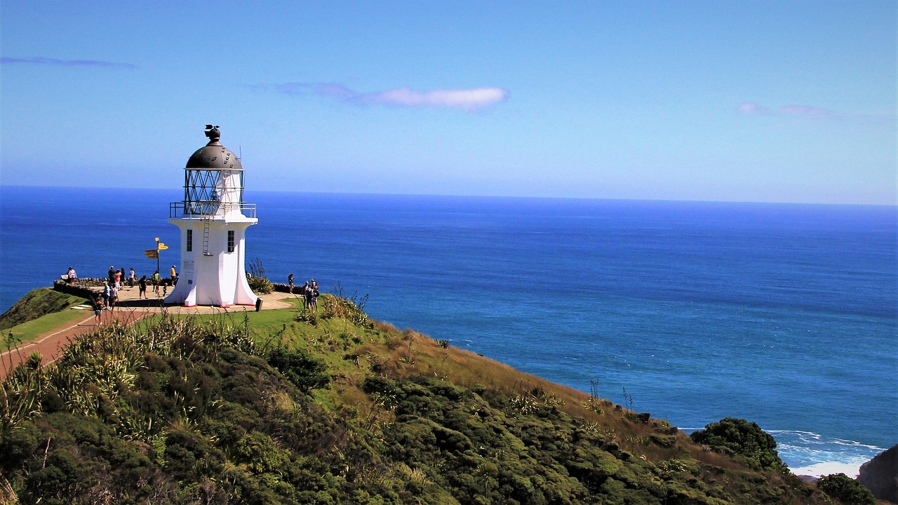
- Cape Reinga / Te Rerenga Wairua: a sealed path of around 1 km from the car park to the lighthouse, where the Tasman Sea and the Pacific meet in a visible line of currents; the old pōhutukawa tree on the rocky point is the place where, according to Māori tradition, spirits depart for the afterlife.
- St Paul’s Rock above Whangaroa: a short, steep climb with chain assistance up the volcanic plug, with views over the intricate harbour.
- CampingSpirit overnight tip
-
Official campsite or RV park: Tapotupotu Campsite, run by the Department of Conservation (DOC), in a sheltered bay a few kilometres before the cape: flush toilets, cold showers, water to be boiled before drinking, no power. The access road is steep and unsealed – think twice in a large motorhome. An alternative further south is the DOC campsite at Rarawa Beach with its white sand. Book online with DOC for the summer.
Free camping or nature tip (where legal): Staying overnight at Cape Reinga itself and in its car park is prohibited; the area is sacred to Ngāti Kuri and all Māori. Freedom camping outside campsites on the Aupōuri Peninsula is largely prohibited or impractical; the DOC campsites are the legal option, including for self-contained vehicles.
- Insider tip for campers
- Between Awanui and the cape there are petrol stations and small shops only at Houhora and Pukenui – fill up in Awanui or Kaitaia. Ninety Mile Beach is officially a road, but practically all rental agreements prohibit driving campervans on it; tides, quicksand and salt water have already claimed many vehicles. DOC asks visitors not to eat at the cape and to treat the place with respect.
6Stage 6: Tapotupotu Bay to Rawene (Hokianga) (approx. 185 km)
- The drive
- Back on SH1 to the turn-off for Te Paki Stream Road and the dunes, then south to Kaitaia and on along SH1 through the forested Mangamuka Gorge – winding and steep, open again after years of closure but temporarily closed after storms (most recently briefly in April 2026). Beyond Mangamuka Bridge, head west on a narrow side road to Kohukohu and take the ferry from the landing at the Narrows across Hokianga Harbour to Rawene. Around 3.5 hours plus ferry time.
- Highlights & must-sees
- Te Paki Sand Dunes: huge golden dunes at the end of Te Paki Stream Road, on foot from the car park; sandboards are hired out on site in season.
- Kohukohu: a tiny village of wooden villas from the kauri logging era on the northern shore of the Hokianga; a bridge dating from 1843 is considered the oldest in New Zealand.
- Hokianga ferry Kohukohu–Rawene: a quarter of an hour across the still fjord with views of the mangroves and the sand dunes at the harbour entrance.
- CampingSpirit overnight tip
-
Official campsite or RV park: Rawene Holiday Park above the village: powered sites, kitchen, toilets and showers, set in the bush and quiet. Walk down to the harbour and to Clendon House (Heritage New Zealand), the home of the first US consul.
Free camping or nature tip (where legal): Far North District Council allows freedom camping only outside the prohibited areas, and on council land only in certified self-contained vehicles. It is not permitted at the ferry landing or in the centre of Rawene. The Hokianga communities are small and consideration is expected – if in doubt, use the holiday park.
- Insider tip for campers
- Te Paki Stream Road ends in the stream bed, which tour buses use to access Ninety Mile Beach: in a campervan, go only as far as the car park and never into the stream bed – there is a risk of quicksand. The Hokianga ferry runs daily roughly every hour with a gap around midday; according to the timetable, the last departure from the Kohukohu side is at 8 pm and from Rawene at 7.30 pm. You pay on board in cash or by card, and campervans pay a higher fare than cars. At low tide there may be restrictions for very large vehicles – check the timetable with Far North District Council or the operator.
7Stage 7: Rawene to Kai Iwi Lakes (Waipoua) (approx. 95 km)
- The drive
- On SH12, the Twin Coast Discovery Highway, along the southern shore of the Hokianga to Ōpononi and Ōmāpere, then uphill into the Waipoua Forest. The road winds narrow and steep through the forest, with individual kauri standing right beside the tarmac. Beyond the forest, continue via Kaihu to the turn-off for the Kai Iwi Lakes. Around 2 hours of driving time; drive slowly in the forest.
- Highlights & must-sees
- Arai te Uru Heritage Walk near Ōmāpere: a short walk to the southern tip of the harbour entrance, facing the high sand dunes of North Head.
- Tāne Mahuta: New Zealand's largest living kauri, a good 50 m tall, reached on a short boardwalk directly from SH12; according to DOC, accessible daily from 9 am to 4 pm.
- Kai Iwi Lakes (Taharoa Domain): three clear dune lakes with white sandy bottoms, for swimming, kayaking and a loop walk around Lake Taharoa.
- CampingSpirit overnight tip
-
Official campsite or RV park: Taharoa Domain Campgrounds at the Kai Iwi Lakes (Pine Beach and Promenade Point), managed by Kaipara District Council: basic facilities with toilets and showers, sites on the lakeshore, book online, early in high season. An alternative in the middle of the forest is the Te Roroa Waipoua Forest Campground on the Waipoua River, with cabins and sites.
Free camping or nature tip (where legal): In the Waipoua Forest, staying overnight outside the campground is prohibited, and the car parks at Tāne Mahuta are for day visitors only. In the Kaipara District, freedom camping on most council land is allowed only in certified self-contained vehicles, for a maximum of two nights in the same place, with departure by 9 am and no return within two weeks; tents are not allowed on public land. Check the prohibited areas with the council.
- Insider tip for campers
- Kauri dieback rules are mandatory: before and after every forest track, scrub and disinfect your shoes at the cleaning station, stay on boardwalks and paths, and don't step on roots. The Kauri Walks with Te Matua Ngahere and the Four Sisters were closed from March 2026 for the construction of a new boardwalk; reopening has been announced for the end of October 2026 – check the current status with DOC. Sandflies are persistent on the Hokianga and at the lakes.
8Stage 8: Kai Iwi Lakes to Auckland (approx. 220 km)
- The drive
- Via Kaihu to Dargaville on the wide Northern Wairoa River, then on SH12 through the Kaipara country via Ruawai and Matakohe to the junction with SH1 at Brynderwyn, over the Brynderwyn Hills and through the Dome Valley back to Auckland. Flat with long straights in the Kaipara, then the same as on the way north. Around 3 hours without stops.
- Highlights & must-sees
- Baylys Beach near Dargaville: part of the roughly 100 km long Ripiro Beach on the Tasman Sea, a walk past bits of shipwrecks and shells.
- Kauri Museum in Matakohe: the history of kauri logging and the kauri gum diggers, with huge trunk sections, tools and a gum collection.
- Dargaville: a small river port with a lighthouse museum on the hill and views over the river plain.
- CampingSpirit overnight tip
-
Official campsite or RV park: For the last night before returning the vehicle, Takapuna Beach Holiday Park on the North Shore is a good choice, right on the beach with views of Rangitoto: powered sites, toilets and showers, dump station and good bus connections to the city centre. Book ahead.
Free camping or nature tip (where legal): Auckland Council allows freedom camping in vehicles only outside the prohibited areas, and on many sites only in certified self-contained vehicles, with a limited length of stay; beach car parks on the east and north coasts are often closed to it. Check the current areas on the council's website.
- Insider tip for campers
- In Dargaville, fill up, shop and empty your grey and black water at the public dump station – rental vehicles usually have to be returned empty. Ripiro Beach is off-limits for rental vehicles. If the Brynderwyns are closed, the transport agency announces detours via side roads, and the journey can take considerably longer; set off early in the morning to avoid the Sunday-afternoon return traffic.
Camping practice & local rules
Wild camping & overnight parking
- Self-Contained Motor Vehicles Legislation Act 2023: freedom camping in a vehicle on council land is now only allowed in certified self-contained vehicles, unless the council expressly permits otherwise. Since 7 December 2024, rental vehicles must carry the green warrant of the new register; the transition period for private vehicles was extended to 7 June 2026. Since then, blue warrants are no longer recognised for freedom camping on public land. A permanently fixed toilet is mandatory for the green warrant; portable toilets are no longer sufficient.
- Fines: if you stay overnight on public land without a green warrant, for example, you risk an infringement fee of NZ$400; with rental vehicles, fines are usually passed on to the hirer. Council rangers regularly check beaches and tourist towns in Northland, especially in summer.
- Councils: Northland is divided between three councils with their own bylaws – Far North (Bay of Islands, Kerikeri, Cape Reinga, Hokianga), Whangārei and Kaipara (Dargaville, Kai Iwi Lakes). All have prohibited areas, often in town centres and on popular waterfronts, as well as limits on length of stay. Signs on site take precedence; maps are on the councils' websites.
- Department of Conservation (DOC): conservation land has its own rules; freedom camping is only allowed where it is not prohibited, and in many places only in a self-contained vehicle. DOC campsites in Northland – such as Tapotupotu, Rarawa Beach, Maitai Bay or Puriri Bay – are inexpensive, have basic facilities and must be booked in summer.
- Sacred sites and Māori land: Cape Reinga, Waitangi and many bays are iwi land or wāhi tapu. Staying overnight, fires and litter are taboo there; access across private or Māori land only with permission.
- Apps: CamperMate (officially supported by the tourism industry, showing freedom camping sites with their rules, dump points and warnings) and WikiCamps with user reviews; cross-check with the council maps before you set off.
Waste disposal & supplies
- Dump points: there are public dump stations in Whangārei, Kerikeri, Kaitaia, Dargaville and at most holiday parks (for guests); locations in CamperMate. Grey water must never be released onto the ground or into stormwater drains.
- Water: tap water in towns and at holiday parks is drinkable; at DOC campsites the water is often untreated and should be boiled or filtered. In dry summers some places in the Far North ration water – watch for signs.
- Gas: New Zealand campervans use LPG bottles (usually 9 kg), which are swapped at petrol stations under an exchange system or refilled at LPG stations. Bottles are only filled with a valid test date; European bottles and fittings don't fit. Gas systems in vehicles need a valid gas certificate.
- Fuel: between Awanui and Cape Reinga and in the Waipoua Forest between Ōmāpere and Dargaville there are few or no petrol stations; fill up in Kaitaia or Awanui before the cape, and in Ōpononi or Dargaville before the forest. Diesel vehicles in New Zealand also pay Road User Charges, which for rental vehicles are covered by the agreement.
- Shopping and mobile coverage: large supermarkets in Whangārei, Kerikeri, Kaitaia and Dargaville. Mobile coverage on the Aupōuri Peninsula, on the Hokianga and in the Waipoua Forest is patchy – save offline maps and booking confirmations.
Vehicle size & traffic rules
- Driving on the left: when turning and at intersections, the rule is “left-turning traffic gives way to oncoming right-turning traffic”. At one-lane bridges, signs show who has priority – very common in Northland.
- Speed limits: usually 100 km/h on the open road, 80 km/h or less on many winding sections in Northland, 50 km/h in towns, and in some cases 30 km/h near schools during school hours. Vehicles over 3.5 t and vehicles towing trailers may not exceed 90 km/h. Signposted advisory speeds for bends are meant seriously.
- Tolls: on this loop, only the Northern Gateway Toll Road (SH1 Orewa–Pūhoi); no toll booths, payment online to NZTA within five days or via an account. The Hibiscus Coast Highway is the toll-free alternative.
- Animals and road conditions: cows, sheep and horses on country roads, possums at night and kiwi warning signs in Northland. After heavy rain, slips and lane closures are common – check NZTA traffic updates.
- Rental vehicles and insurance: beach driving (Ninety Mile Beach, Te Paki Stream, Ripiro Beach) is prohibited in practically all rental agreements, many agreements also restrict unsealed roads, and damage there is usually not covered. The access roads to some DOC campsites are gravel – check your agreement in advance.
- Licence and alcohol: a foreign driving licence is valid for up to 12 months if it is in English or carried with an official translation or an International Driving Permit. The blood alcohol limit is 0.5 for drivers aged 20 and over and 0.0 for younger drivers; a mobile phone may only be used at the wheel in a mount and without holding it in your hand.
CampingSpirit packing & preparation checklist
- Sandfly repellent: on the Hokianga, at the Kai Iwi Lakes and at DOC campsites the tiny insects bite at dusk; also bring long, light-coloured clothing.
- Easy-to-clean walking shoes and a small brush: the kauri dieback stations require clean soles with no soil left on them; deep tread makes cleaning take longer.
- Foldable sandboard or a simple sledging mat: for the Te Paki dunes, in case the hire is closed out of season.
- Snorkelling mask: for the clear bays in the Bay of Islands, Matauri Bay and Maitai Bay.
- Water hose with a universal tap adapter: taps at holiday parks and dump points have different fittings.
- Rain jacket: the subtropical climate brings heavy rain fronts even in summer, with storms on the west coast.
As of 2026-09. Closures, fees and booking rules change: check official sources before you go.