Lake Superior Circle Tour
The Lake Superior Circle Tour is a signed loop of about 1,300 miles through Michigan, Wisconsin, Minnesota and Ontario. It crosses the border twice and passes many state and provincial parks.
- States
- Michigan, Wisconsin, Minnesota, Ontario
- Length
- About 1,300 mi (2,100 km)
- Start / end
- Sault Ste. Marie (loop)
- Suggested time
- 4 to 14 days (about 9 recommended)
- Best season
- Late May to mid-October
What should you know before visiting Lake Superior Circle Tour?
Tolls and vignettes for a car: about $2 (IL).
- Michigan has the longest share at about 515 miles, followed by Ontario at 474, Minnesota at 154 and Wisconsin at 142. The signs went up in summer 1986.
- For the two border crossings (Sault Ste. Marie and Pigeon River), every person in the vehicle needs proper identification. Check current rules with the border agencies.
- Time zones change: most of the Upper Peninsula and all of Ontario use Eastern Time, while parts of the western peninsula, Wisconsin and Minnesota use Central Time.
- Time zones change: most of the Upper Peninsula and Ontario along the route use Eastern Time, while parts of the western peninsula, Wisconsin and Minnesota use Central Time.
The drive
In Michigan the route enters from Wisconsin at Ironwood and uses US-2, M-28, M-64, M-38, M-26 and US-41, with a loop at Calumet and Hancock, then Marquette, Munising, Seney and Newberry to Tahquamenon Falls and Paradise. I-75 leads to Sault Ste. Marie and the International Bridge into Ontario. There the tour follows Highway 17 along the north shore and Highway 61 from Thunder Bay to the Pigeon River. Signs are white on brown.
Camping
Along the route are Tahquamenon Falls, Porcupine Mountains and Fort Wilkins (Michigan), Grand Portage (Minnesota), and Sleeping Giant, Rainbow Falls and Lake Superior Provincial Park (Ontario). Pictured Rocks and the Apostle Islands are national lakeshores. On Ontario Crown land the limit is 21 days per site per calendar year, then move at least 100 m; no camping on roads or parking lots. In the US, ask state parks and forest agencies about rules and reservations beforehand.
Planning
Driven hard, the loop takes four to five days; experienced travelers recommend nine days, and two weeks is possible. Late May and early June are usually quieter, and late September to mid-October is peak fall color. In April some campgrounds, stores and restaurants may still be closed, and heavy snow is possible. Cell and GPS coverage drops in places, so carry a paper map.
FAQs
How long does the Lake Superior Circle Tour take?
Driven hard, four to five days. Experienced travelers recommend about nine, and a relaxed trip can take two weeks. Fall color peaks from late September to mid-October.
Where does the tour cross the US–Canada border?
At Sault Ste. Marie over the International Bridge and at the Pigeon River near Grand Portage. All occupants need proper identification. Check current entry rules with the border agencies before you go.
Can I camp for free in Ontario?
On most Crown land, yes, for private use and up to 21 days per site per year. Non-residents of Canada usually need a permit north of the French and Mattawa Rivers, but renters of a camping unit from an Ontario business are exempt. Follow posted signs.
How much are the tolls on Lake Superior Circle Tour?
Tolls and vignettes for a car: about $2 (IL). Estimate with typical rates; motorhomes pay more, and vehicles over 3.5 t often pay by distance.
Places to see
 © bogdanstepniak · CC BY 3.0
Sleeping Bear Dunes
Sand bluffs 450 feet above Lake Michigan. The Pierce Stocking Scenic Drive has the best overlooks.

 © Sharon Mollerus · CC BY 2.0
Split Rock Lighthouse
A lighthouse on a 130-foot cliff above Lake Superior, built after a storm wrecked 29 ships.
 © Isabella Rick · CC BY 3.0
Pictured Rocks
Sandstone cliffs streaked with mineral colours above Lake Superior. See them by boat or kayak.
 © National Park Service · Public domain
Voyageurs National Park, Rainy Lake
A park that is mostly water, with rocky islands and bays along the Canadian border. The Rainy Lake visitor…

 © Notorious4life (talk) (Uploads) · CC0
Tunnel of Trees (M-119)
A narrow, winding road under a canopy of hardwoods on the bluff above Lake Michigan. There is no center…

 © Antony-22 · CC BY-SA 4.0
Tahquamenon Falls
A 200-foot-wide waterfall colored root-beer brown by tannins, with the Lower Falls four miles downstream. A…
 Photo by Dillon Austin on Unsplash
Mackinac Bridge
A five-mile suspension bridge linking Michigan's two peninsulas. Ferries to car-free Mackinac Island leave…
 © NPS Photo · Public domain
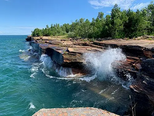
Apostle Islands sea caves
Red sandstone caves along the lakeshore, reached by kayak in summer or on foot when the lake freezes.
Trip guides

 Photo by Jeff DeWitt on Unsplash
Lake Michigan's dune coast

 Photo by Luke Tanis on Unsplash
Lake Superior’s north and south shores

 © Lorie Shaull · CC BY 2.0
Minnesota North Woods: iron mines to Voyageurs
 © Notorious4life (talk) (Uploads) · CC0