Cape Arago State Park
Coos Bay, OR
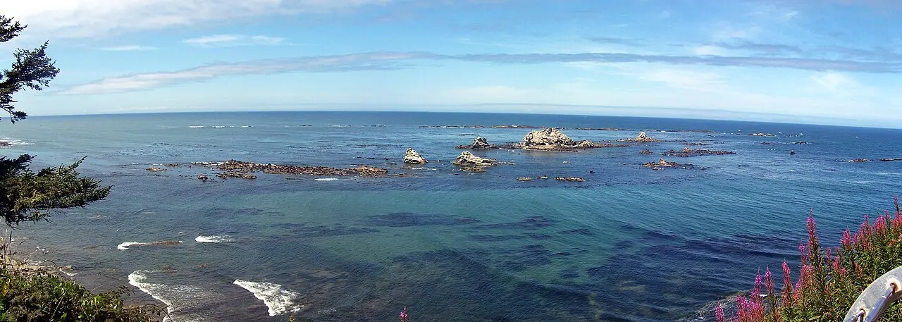
The end of the Cape Arago Highway, with tide-pool coves below and sea lions barking on Shell Island and Simpson Reef. Stop at the Simpson Reef Overlook just before the cape with binoculars.
Cape Arago State Park lies at the end of the Cape Arago Highway on Oregon's south coast, about 24 kilometers (15 miles) from Coos Bay. The road passes Sunset Bay and Shore Acres and ends here. The viewpoints look out to Simpson Reef and Shell Island, part of the Oregon Islands National Wildlife Refuge; the rocks are off limits. Simpson Reef is considered Oregon's largest haul-out for seals and sea lions, with California and Steller sea lions, northern elephant seals and harbor seals. You can often hear the barking of the sea lions from far away.
At low tide the coves reveal tide pools. A zigzag path drops about 37 meters (120 feet) down to South Cove. The trail to the viewpoint at North Cove is closed from March 1 to June 30 to protect seal pups. Three parking areas sit along a loop road, and a day-use parking permit is required. The viewpoints take about half an hour; plan half a day for the coves and tide pools.
- Nearest town
- Coos Bay, OR
- Category
- Nature & parks
- GPS
- 43.3071, -124.3985
Hours, fees and access change. Confirm with the operator or park before you go.
Good to know
Best time to go
The most pleasant months are usually May–September. Still fine, with some compromises, in April and October. (Estimate from long-term temperature averages, terrain and pass seasons)
Sources
Featured in these trip guides

Nearby




Campsites nearby
- Sun Outdoors Coos BayMotorhome stopover3 mi from Cape Arago State ParkMotorhomes
- Charleston Marina RV ParkMotorhome stopover4 mi from Cape Arago State ParkMotorhomes
- Bay Point LandingMotorhome stopover7 mi from Cape Arago State ParkMotorhomes
- Hiker / Biker CampCampsite11 mi from Cape Arago State ParkTentsElectricityDrinking waterShowersToilets
- Bullards Beach State Park CampgroundCampsite11 mi from Cape Arago State ParkTentsCaravansElectricityDrinking waterShowersToiletsWaste disposal
- Eel Creek CampgroundCampsite22 mi from Cape Arago State ParkTentsCaravans
All campsites in Oregon · Campsite data: © OpenStreetMap contributors, ODbL 1.0 · Updated October 3, 2026
FAQs
Where is Cape Arago State Park?
Cape Arago State Park is in Coos Bay, OR, at GPS 43.3071, -124.3985. It is about 13 mi from Bandon.
Can you camp near Cape Arago State Park?
Yes. The nearest campsite listed in OpenStreetMap is Sunset Bay Campground, about 2 mi away; within 25 mi there are 32 campsites and motorhome stopovers.
Which road trips pass Cape Arago State Park?
Cape Arago State Park is a stop on these CampingSpirit trip guides: Southern Oregon coast: Cape Arago to the Boardman corridor.
What is there to see near Cape Arago State Park?
Places worth a stop nearby: Shore Acres State Park (1 mi), Sunset Bay State Park (2 mi), Face Rock (14 mi) and Cape Blanco Lighthouse (34 mi).
When is the best time to visit Cape Arago State Park?
The most pleasant months are usually May–September. Still fine, with some compromises, in April and October. (Estimate from long-term temperature averages, terrain and pass seasons)