
Mount Stewart
Greyabbey, United Kingdom
A 19th-century house with some of the most admired gardens in the British Isles, on the shore of Strangford Lough. The National Trust charges entry; it lies on the A20 about 25 km from Belfast.
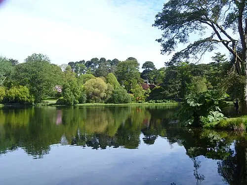
Mount Stewart lies on the east shore of Strangford Lough near Greyabbey, County Down. The Stewart family acquired the estate in 1744; the present house was built between 1820 and 1839 for the Marquesses of Londonderry. It is famous for the gardens laid out by Edith, Lady Londonderry, in the early 20th century, including the Italian and Spanish gardens, the Sunken Garden and the Dodo Terrace with its cement animals. The Temple of the Winds, overlooking the lough, was designed by James “Athenian” Stuart (1782–83). The gardens passed to the National Trust in 1957 and the house in 1977.
One guidebook gives the garden as about 80 acres (roughly 32 hectares), with woodland and lakeside areas such as Lily Wood and Jubilee Walk in addition; it recommends a full day, and the RHS highlights the autumn colour. In January 2025 Storm Éowyn brought down more than 10,000 trees on the estate, so ask the National Trust about the current state of the paths. There is a car park, café and restaurant, and the house can be visited.
- Nearest town
- Greyabbey, United Kingdom
- Category
- History & culture
- GPS
- 54.5537, -5.6022
Hours, fees and access change. Confirm with the operator or park before you go.
Good to know
Best time to go
No month is ideal everywhere on this route; the most pleasant are usually May–September. (Estimate from long-term temperature averages, terrain and pass seasons)
Getting there
- United Kingdom: Tolls on some roads, bridges or tunnels. Drive on the left. Some bridges and tunnels charge tolls.
Featured in these trip guides


Nearby









Campsites nearby
- EDYC Caravan and Camping AreaCampsite16 km from Mount StewartWaste disposal
- Lorne EstateCampsite17 km from Mount Stewart
- Delamont Country ParkCampsite19 km from Mount StewartTentsCaravans
- Castle Ward Caravan ParkCampsite21 km from Mount StewartTentsCaravans
- Jordanstown Loughshore Caravan ParkMotorhome stopover23 km from Mount StewartMotorhomes
- Strangford Holiday ParkMotorhome stopover24 km from Mount StewartMotorhomesElectricityWaste disposal
All campsites in United Kingdom · Campsite data: © OpenStreetMap contributors, ODbL 1.0 · Updated October 3, 2026
FAQs
Where is Mount Stewart?
Mount Stewart is in Greyabbey, United Kingdom, at GPS 54.5537, -5.6022. It is about 20 km from Portaferry.
Can you camp near Mount Stewart?
Yes. The nearest campsite listed in OpenStreetMap is Ballywhiskin Caravan and Camping Park, about 7 km away; within 25 km there are 14 campsites and motorhome stopovers.
Which road trips pass Mount Stewart?
Mount Stewart is a stop on these CampingSpirit trip guides: Strangford Lough and the Mourne Mountains and Granite, tides and cathedrals – by camper through the Mournes, around Strangford Lough and on to Armagh.
What is there to see near Mount Stewart?
Places worth a stop nearby: Castle Ward (20 km), Tollymore Forest Park (42 km), Mull of Galloway (49 km) and Silent Valley Reservoir (54 km).
When is the best time to visit Mount Stewart?
No month is ideal everywhere on this route; the most pleasant are usually May–September. (Estimate from long-term temperature averages, terrain and pass seasons)