
Signal de Botrange
Waimes, Belgium
At 694 m the highest point in Belgium, on the edge of the High Fens moorland with its boardwalk trails. Some fen areas close in dry spells because of fire risk; check at the Botrange nature centre nearby.
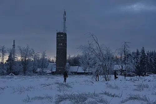
Signal de Botrange, near Waimes in the province of Liège, is the highest point in Belgium at 694 m. It lies on the plateau of the High Fens (French: Hautes Fagnes) in the east of the country; a road crosses the summit and a café stands beside it. A 6 m structure built in 1923 adds a little extra height, so that you can stand at around 700 m. In winter, several cross-country ski trails start here.
The Botrange Nature Park Centre is the starting point for walks, among them the trail "Through the Botrange Fens" (6.4 km); the Mont Rigi Walk (7.2 km) is also waymarked. In August 2026 a large fire destroyed parts of the High Fens. Access roads, official car parks and cafés had reopened by late August, but closures still applied in the burnt area (as of September 2026). Check with the East Belgium tourist board before you set out and follow the signs on site.
- Nearest town
- Waimes, Belgium
- Category
- Nature & parks
- GPS
- 50.5013, 6.0935
Hours, fees and access change. Confirm with the operator or park before you go.
Good to know
Best time to go
The most pleasant months are usually June–September. Still fine, with some compromises, in May and October. Cold, short days in December–February. (Estimate from long-term temperature averages, terrain and pass seasons)
Getting there
- Belgium: No motorway tolls for cars. Low-emission zones in Brussels, Antwerp and Ghent; register foreign vehicles. Motorway limit for cars: 120 km/h.
Sources
Featured in these trip guides

Nearby









Campsites nearby
- Camping des CharmillesCampsite3 km from Signal de BotrangeTentsCaravansElectricityDrinking waterShowersToilets
- Zum Jone BurCampsite14 km from Signal de BotrangeTentsCaravansElectricityDrinking waterShowersToilets
- Camp-HammerCampsite18 km from Signal de BotrangeTentsCaravansElectricityDrinking waterShowersWaste disposalNo dogsWi-Fi
- Natur-Camping HammerbrückeCampsite23 km from Signal de BotrangeTentsCaravansElectricityDrinking waterShowersToilets
- SchafbachmühleCampsite23 km from Signal de BotrangeTentsCaravansElectricityShowersToiletsWi-Fi
- Wildbach CampingCampsite24 km from Signal de Botrange · 150 pitchesTentsCaravansMotorhomesElectricityDrinking waterShowersToiletsWaste disposalWi-Fi
All campsites in Belgium · Campsite data: © OpenStreetMap contributors, ODbL 1.0 · Updated October 3, 2026
FAQs
Where is Signal de Botrange?
Signal de Botrange is in Waimes, Belgium, at GPS 50.5013, 6.0935. It is about 10 km from Malmedy.
Can you camp near Signal de Botrange?
Yes. The nearest campsite listed in OpenStreetMap is Camping des Charmilles, about 3 km away; within 25 km there are 65 campsites and motorhome stopovers.
Which road trips pass Signal de Botrange?
Signal de Botrange is a stop on these CampingSpirit trip guides: High Fens and the Belgian Ardennes: Spa to Bastogne.
What is there to see near Signal de Botrange?
Places worth a stop nearby: Monschau (12 km), Coo Waterfall (19 km), Vaalserberg Three-Country Point (29 km) and Aachen Cathedral (30 km).
When is the best time to visit Signal de Botrange?
The most pleasant months are usually June–September. Still fine, with some compromises, in May and October. (Estimate from long-term temperature averages, terrain and pass seasons)