

In-depth guide · CampingSpirit
From Mile 0 of the Alaska Highway into the Tumbler Ridge UNESCO geopark, over gravel to Kinuseo Falls and along the Peace River to Fort St. John – a week among coal mountains, Cretaceous footprints and power stations.
The spirit of the route
Up here the morning smells of spruce resin and wet gravel. You slide the door open and in front of you there is no picture-postcard panorama, just space: canola and oat fields around Dawson Creek, then dark forests rising towards the foothills of the Rocky Mountains. In the creek beds near Tumbler Ridge, ankylosaurs and predatory dinosaurs left their prints more than a hundred million years ago, and you wade barefoot right beside them. At the end of a dusty forest road the Murray River plunges over Kinuseo Falls; in the evening you sit by a campfire made with wood you brought yourself while a moose wanders through the willows on the bank. Later, below Hudson’s Hope, the Peace River runs through a canyon tamed by dams. This is working country – gas, coal, timber – with pick-ups and trucks on every road, and that is exactly what makes it honest: few crowds, lots of space, long evenings in June.
Stage-by-stage plan
1Stage 1: Dawson Creek to Tumbler Ridge (via Pouce Coupe and Highway 52 East) (approx. 185 km)
- The drive
- Dawson Creek is just the starting point: a quick stop at the Mile 0 post of the Alaska Highway, then around 10 kilometres south-east on Highway 2 to Pouce Coupe and on through farmland to Tupper near the Alberta border. There Highway 52 East (part of the “Heritage Highway”) branches off to the south – just under 145 kilometres to Tumbler Ridge, hilly, through aspen and spruce forest, with hairpin bends that drop into the valley shortly before town. The road is mostly chip-sealed, with a section of around 36 kilometres of gravel; depending on rain it is firm or soft and slippery. Total driving time three to four hours. If you want to avoid gravel, take the fully paved alternative from Dawson Creek via Highway 97 to Arras and Highway 52 south (around 120 kilometres).
- Highlights & must-sees
- Mile 0 in Dawson Creek: post and memorial cairn at the start of the Alaska Highway, plus the visitor centre in the old grain elevator area. If you want to explore the Peace Country in depth, the region around Dawson Creek and Grande Prairie is covered in the CampingSpirit guide “Wide open spaces, honey and Mile 0 – by camper through the Peace Country to the Alaska Highway”.
- Pouce Coupe: small town with a museum in the historic Northern Alberta Railways station; a chance to stretch your legs before settlements thin out.
- Bearhole Lake on Highway 52 East: quiet forest lake with a basic site, good for a lunch break with a view of the water and a chance of beavers and waterbirds.
- CampingSpirit overnight tip
-
Official campsite or RV park: Lions Flatbed Creek Campground, around one kilometre from the centre of Tumbler Ridge on Flatbed Creek: about 40 sites without hook-ups, flush toilets, hot showers and its own sani-dump; bookable online, register before entering. The trails to the pools and the dinosaur trackway on Flatbed Creek start right at the campground.
Free camping or nature tip (where legal): In British Columbia you can generally camp on Crown land for up to 14 days in the same spot unless a ban is posted. Around Tumbler Ridge there are basic recreation sites (such as Bearhole Lake or Moose Lake), usually with a toilet and fire ring, on a “first come, first served” basis. Check conditions and access with Recreation Sites and Trails BC or the visitor centre in Tumbler Ridge.
- Insider tip for campers
- Fill up the tank, buy groceries and top up water in Dawson Creek – there are hardly any services before Tumbler Ridge. Before setting off, check DriveBC to see whether the gravel section of Highway 52 East is passable after rain; if in doubt, take the paved route via Arras. A note on the clock: north-eastern BC stays on Mountain Standard Time all year round.
2Stage 2: Tumbler Ridge to Tumbler Ridge (geopark day) (approx. 40 km)
- The drive
- A day based in the Tumbler Ridge UNESCO Global Geopark: short drives on asphalt and well-maintained gravel access roads to trailhead car parks, mostly less than 20 kilometres from town. The geopark covers a large area with dozens of marked trails, more than 30 waterfalls and numerous geosites – from coal seams to sandstone overhangs. Some access roads are narrow and unsuitable for long rigs; in that case park on the main road and walk the last stretch.
- Highlights & must-sees
- Dinosaur Discovery Gallery: museum run by the local museum foundation with finds from the region, including an armoured ankylosaur that left many of the tracks, and casts of large predatory dinosaurs. In summer, guided tours to the trackways are offered, some in the evening by lantern light; ask locally for dates.
- Flatbed Pools and dinosaur trackway: trail network right on Flatbed Creek with pools, a small waterfall under a sandstone overhang and the trackway slab in the creek bed, discovered in 2000 by two boys tubing down the creek. At high water the prints are submerged.
- Murray Canyon Overlook and Quality Falls: two of the popular half-day trails, one with a view into the gorge of the Murray River (around 5.5 kilometres return), the other a short forest path to a waterfall – easy to combine.
- CampingSpirit overnight tip
-
Official campsite or RV park: Monkman RV Park in Tumbler Ridge: large park with around 55 pull-through sites with hook-ups, hot showers and washing machines; book via its own website. If you would rather stay by the water, extend your stay at Lions Flatbed Creek Campground.
Free camping or nature tip (where legal): In town itself, overnighting in a vehicle on streets and in car parks is not intended. Free spots are only found outside town on Crown land or at the recreation sites in the area; industrial access roads to mines and gas facilities are off-limits.
- Insider tip for campers
- Use the public sani-dump on Ridge Road before heading to Kinuseo Falls – there is no dump station there. The visitor centre has the geopark hiking map and current notes on bear sightings; black bears are regularly about on several trails.
3Stage 3: Tumbler Ridge to Kinuseo Falls (Monkman Provincial Park) (approx. 65 km)
- The drive
- Around 13 kilometres south on Highway 52 East, then right onto Kinuseo Falls Road. The next 50-plus kilometres to the falls are gravel all the way, with washboard, potholes and loose chippings, plus dust in dry weather. The road passes active and closed coal mines and runs under haul roads; expect heavy dump trucks and industrial traffic. Speed 40–60 km/h, driving time about an hour and a half. In winter the road is only maintained as far as kilometre 21, and the falls cannot be reached by vehicle.
- Highlights & must-sees
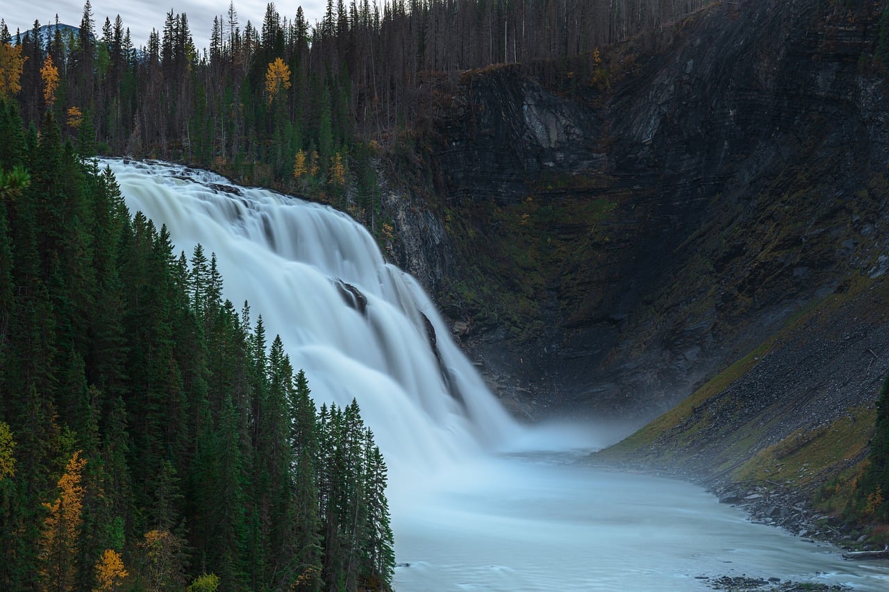
- Kinuseo Falls: the Murray River drops around 60 metres over a broad rock step. A low-barrier main trail from the day-use car park leads to the lower viewing platform, and a longer, steeper path to the upper viewpoint looking over the brink. The unofficial descent to the foot of the falls is dangerous and not permitted; follow on-site notices about closed platforms.
- Monkman Cascades Trail: the multi-day trail to Monkman Lake (around 50 kilometres return, three to four days, for experienced hikers with good navigation skills only) starts at the campground; as a day hike, the first 7 kilometres or so to the suspension bridge over the Murray River are worthwhile.
- Picnic area on the Murray River, around two kilometres from the campground: gravel bars, calm evening light and a good chance of moose on the bank.
- CampingSpirit overnight tip
-
Official campsite or RV park: Kinuseo Falls Campground (BC Parks) in Monkman Provincial Park, near the falls on the Murray River: 42 basic sites, pit toilets, picnic tables and fire rings; no electricity, no dump station. A boil-water advisory was most recently in place for water in the park – bring your own drinking water. Firewood is not sold and collecting wood in the park is prohibited – bring your own locally sourced wood. Season usually from the Wednesday before the Victoria Day long weekend (mid/late May) into the autumn; check reservability (in the past mostly “first come, first served”) and fees on bcparks.ca.
Free camping or nature tip (where legal): Within the provincial park, only at the campground. Along the Forest Service Road there is Crown land outside the park, but pull-outs and access roads are used by industrial traffic and are unsuitable for parking up; the recreation sites around Tumbler Ridge are the better choice.
- Insider tip for campers
- Lower your tyre pressure slightly for gravel, keep your distance from vehicles in front and pull over slowly for oncoming traffic – a stone chip in the windscreen is the typical damage here. On Forest Service Roads, industrial vehicles effectively have right of way; note the kilometre signs in case you need to call for help. There is no mobile coverage in the park.
4Stage 4: Kinuseo Falls to Moberly Lake (via Tumbler Ridge, Gwillim Lake and Chetwynd) (approx. 185 km)
- The drive
- Back along the gravel road to Tumbler Ridge (around 65 kilometres), then about 95 kilometres north on Highway 29 to Chetwynd: a well-built paved road over hills and through forest, past Gwillim Lake, with timber and coal trucks coming the other way. In Chetwynd, Highway 29 meets Highway 97 (John Hart Highway). Continue on Highway 29 towards Hudson’s Hope for around 25 kilometres to Moberly Lake. Driving time four to five hours with breaks.
- Highlights & must-sees
- Gwillim Lake Provincial Park: long, narrow lake right on Highway 29, good for a lunch break by the water or a short walk along the shore.
- Chainsaw sculptures in Chetwynd: more than a hundred wooden sculptures – bears, moose, mythical creatures – are dotted around town, many of them from the international chainsaw carving competitions held here every year in early summer. A map for the walking tour is available at the visitor centre.
- Moberly Lake: large, deep lake in a forested basin, often mirror-calm in the evening; swimming beach and boat launch in the provincial park.
- CampingSpirit overnight tip
-
Official campsite or RV park: Moberly Lake Provincial Park on the lakeshore: large campground with just over 100 sites, drinking water, pit toilets, sani-dump (for a fee), swimming beach and boat launch; there is no electricity. Some of the sites can usually be booked via the BC Parks reservation system, the rest are “first come, first served” – check the current status on camping.bcparks.ca. Alternative halfway along: Gwillim Lake Provincial Park with 49 basic sites, water pump, pit toilets and boat launch, no reservations.
Free camping or nature tip (where legal): Between Chetwynd and Hudson’s Hope there is plenty of Crown land; free camping is allowed where it is not prohibited by signage and no gas or logging access road is blocked. Around Moberly Lake there is land belonging to the Saulteau First Nations and the West Moberly First Nations – only enter reserve land with permission.
- Insider tip for campers
- Chetwynd is the best supply point between Tumbler Ridge and Hudson’s Hope: supermarket, several petrol stations, propane. Fill up with fresh water here too; Moberly Lake has only basic facilities, and the sani-dump in the park charges a fee.
5Stage 5: Moberly Lake to Hudson’s Hope and W.A.C. Bennett Dam (approx. 95 km)
- The drive
- Around 40 kilometres north on Highway 29, over hills with wide views, to the Peace River at Hudson’s Hope; just before town the road crosses the river below the Peace Canyon Dam. From Hudson’s Hope the paved Canyon Drive runs just over 20 kilometres west to the W.A.C. Bennett Dam, then back. Quiet roads, total driving time around two hours.
- Highlights & must-sees
- W.A.C. Bennett Dam: one of the largest earth-fill dams in the world, completed in the late 1960s, it impounds the Peace River to form Williston Lake, the largest lake in British Columbia. The BC Hydro visitor centre has information on the construction, power station and nature, with guided tours and audio guides; open only from about late May to late summer, check times in advance.
- Peace Canyon and Dinosaur Lake: below the Bennett Dam lies the smaller Peace Canyon Dam; the reservoir, Dinosaur Lake, owes its name to the dinosaur tracks found in the canyon before it was flooded, some of which were recovered. Viewpoints along the road look into the canyon.
- Hudson’s Hope Museum: small museum on the town’s history since Alexander Mackenzie and on the region’s dinosaurs, with fossils and trackway casts; next door is a historic log church. Seasonal opening hours.
- CampingSpirit overnight tip
-
Official campsite or RV park: Alwin Holland Campground, a municipal campground around three kilometres south of town on the Peace River: twelve basic sites without hook-ups, pit toilets, fire rings and a path down to the river; only for vehicles up to 21 ft (around 6.4 metres). For larger vehicles: the municipality’s Dinosaur Lake Campground, seven kilometres south on the reservoir, with 17 basic sites, boat launch and pit toilets. At both, some sites can be reserved online and the rest are “first come, first served”; season from the Victoria Day long weekend to Labour Day. The municipal King Gething campground is also in town; check the facilities of private RV parks in advance.
Free camping or nature tip (where legal): Around Hudson’s Hope there is Crown land on Williston Lake and the Peace River. Reservoir shores and BC Hydro land may be closed, and water levels fluctuate greatly – do not drive onto mud or gravel on the shore.
- Insider tip for campers
- Get to the Bennett Dam early in the day: the light over Williston Lake is clearer in the morning, and in high summer the car park is still cool then. Hudson’s Hope has a petrol station and a small shop, but not much choice – do bigger shops in Chetwynd or Fort St. John.
6Stage 6: Hudson’s Hope to Fort St. John (via Taylor) (approx. 130 km)
- The drive
- Highway 29 follows the Peace River Valley east for around 90 kilometres to the Alaska Highway at Charlie Lake, winding and with climbs at the side valleys. Because of the Site C dam reservoir, around 30 kilometres of the road were realigned in six sections and five new bridges were built, including the bridge over the Halfway River, more than a kilometre long; much of the former river landscape is now flooded. Then on Highway 97 through Fort St. John around 20 kilometres south to Taylor and back. Heavy traffic of pick-ups, gas and logging trucks around Fort St. John. Driving time about two and a half hours.
- Highlights & must-sees
- Peace River Valley and Site C: viewpoints on Highway 29 show the broad valley, now partly dammed. The Site C dam south-west of Fort St. John is a controversial major project; there is practically no visitor access to the site, and you only see it from a distance.
- Peace River Bridge at Taylor: the Alaska Highway bridge, opened in 1960, spans the river where the original suspension bridge collapsed in October 1957; easy to see from the riverbank at Taylor and from Peace Island Park.
- Fort St. John and Charlie Lake: the largest city in the region, with the North Peace Museum; Charlie Lake north of town is a good place for an evening stroll.
- CampingSpirit overnight tip
-
Official campsite or RV park: Beatton Provincial Park on the east shore of Charlie Lake, around 16 kilometres north-west of Fort St. John: campground in aspen forest with drinking water, pit toilets, swimming beach, boat launch and playground; some sites reservable through BC Parks. In summer, blue-green algae can occur in the lake – heed warning notices. Alternatively Charlie Lake Provincial Park right on the Alaska Highway, or Peace Island Park in Taylor, a municipal campground on an island in the Peace River; check facilities and season in advance.
Free camping or nature tip (where legal): Around Fort St. John there is a lot of private and industrial land; free camping is difficult and prohibited on access roads to gas and oil facilities. In the city, only sleep in your vehicle where it is expressly permitted; better to use one of the campgrounds mentioned.
- Insider tip for campers
- Fort St. John is the supply hub of the north-east: big supermarkets, propane, tyre services and repair shops – have any stone chip in the windscreen checked here before heading further north on the Alaska Highway. At shift-change times in the morning and late afternoon, the access roads are busy.
Camping practice & local rules
Wild camping & overnight parking
- Crown land: in British Columbia you can generally camp on public land (Crown land) for up to 14 days in the same spot unless a ban is posted. Exceptions are private land, First Nations reserves, provincial parks outside campgrounds, and industrial land, gas access roads and mine sites.
- Recreation sites (Recreation Sites and Trails BC): basic sites with a toilet and fire ring by lakes and creeks, some free, some with a small fee; allocated on a “first come, first served” basis. There is a network of such sites around Tumbler Ridge.
- BC Parks: some campgrounds can be reserved via camping.bcparks.ca, with the booking window opening a few months ahead; smaller sites such as Gwillim Lake are “first come, first served”; for Kinuseo Falls, check the current status. In the north-east, sites are rarely full outside long weekends.
- Wildfire season: in summer, fire bans, area closures and evacuation orders are common; when there is smoke, the situation can change within hours. Before each stage, check BC Wildfire Service (bcwildfire.ca) and DriveBC; gas stoves are usually allowed, campfires not always.
- Wildlife: black bears are common in the geopark and in Monkman Provincial Park, grizzlies possible in the mountains. Carry bear spray within reach, store food and rubbish in the vehicle. Moose, deer and caribou stand on the road, especially at dawn and dusk.
- Apps: iOverlander, Campendium and The Dyrt; Park4Night is not widely used here. Download offline maps, as there is no mobile coverage away from towns.
Waste disposal & supplies
- Dump stations: in Dawson Creek, Tumbler Ridge (public sani-dump on Ridge Road and at Lions Flatbed Creek Campground), Chetwynd and Fort St. John, and (for a fee) in Moberly Lake Provincial Park; usually none in the other provincial parks along the way. Empty your tanks before driving to Kinuseo Falls.
- Drinking water: at campgrounds with a tap or pump and in towns; always filter or boil lake and river water. For the Kinuseo stage, take enough water for two days.
- Only empty grey water and chemical toilets at dump stations; discharging on Crown land or into waterways is prohibited.
- Propane: in Dawson Creek, Chetwynd and Fort St. John at petrol stations and specialist dealers; European cylinders are generally not filled, and rental motorhomes have built-in tanks.
- Fuel: petrol stations in Dawson Creek, Tumbler Ridge, Chetwynd, Hudson’s Hope, Taylor and Fort St. John. There are none between Tupper and Tumbler Ridge or on the Kinuseo stage – set off with a full tank each time.
- Shopping: big supermarkets in Dawson Creek and Fort St. John, a decent choice in Chetwynd and Tumbler Ridge, only a small shop in Hudson’s Hope.
Vehicle size & traffic rules
- Speed limits: Highways 97, 29 and 52 mostly 90–100 km/h, 50 km/h in towns; drive considerably slower on Forest Service Roads. Roadworks with traffic lights and pilot vehicles are common in summer.
- Winter tyres: on most highways in northern BC, including here, winter tyres or chains are required from 1 October to 30 April as signposted; equip motorhomes accordingly in the autumn.
- Vehicle dimensions in BC: height up to 4.15 m, width up to 2.6 m. No tolls on the route.
- Industrial and truck traffic: gas, coal and timber transport dominates every road. On Forest Service Roads, loaded trucks effectively have right of way; keep right, turn your lights on in dust and increase your distance. Never block access roads to facilities.
- Time zone: north-eastern British Columbia (Dawson Creek, Fort St. John, Chetwynd, Tumbler Ridge, Hudson’s Hope) stays on Mountain Standard Time all year round – the same time as Vancouver in summer and as Alberta in winter.
- Emergencies: 911; mobile coverage drops out away from towns. Carry a satellite communicator or Starlink device and leave a travel plan with someone. DriveBC (drivebc.ca) shows closures and road conditions.
CampingSpirit packing & preparation checklist
- Stone-chip protection for the windscreen and a repair kit for small chips: on Kinuseo Falls Road and the gravel stretch of Highway 52 East, chippings fly and trucks throw up stones.
- Compressor and tyre pressure gauge: lower the pressure for gravel and pump back up before returning to asphalt.
- Your own firewood (bought locally) and an axe: no wood is sold in Monkman Provincial Park, and collecting is prohibited.
- Bear spray with holster: black bears are regularly about on the geopark trails and along the Murray River.
- Mosquito screens for doors and windows, a head net and repellent with DEET or picaridin: mosquitoes and blackflies are a real nuisance by lakes and creeks in June and July.
- Water shoes or sandals with grip: the dinosaur tracks on Flatbed Creek are in the creek bed, and the sandstone slabs are slippery.
As of 2026-10. Closures, fees and booking rules change: check official sources before you go.