

In-depth guide · CampingSpirit
From Caen past William the Conqueror’s castle, the loops of the Orne and the pear orchards of Domfront to the manor houses of the Perche and the cheese villages of the Pays d’Auge: around 520 kilometres of Normandy without the sea, on roads between hedgerows that take more time than the map promises.
The spirit of the route
This Normandy smells not of salt but of wet grass, woodsmoke and fermenting apples. South of Caen the plain suddenly tips into ancient bedrock: the Orne has eaten its way through slate and sandstone, climbers hang from the Rochers des Parcs, and from the Pain de Sucre you see canoes like dashes on the dark water. Further south the land turns into bocage, sunken lanes between hedgerows, cows beneath pear trees that blossom white in April. Bagnoles greets you with villas and a spa park, Carrouges with red brick in a moat, Alençon with a lace you only grasp under a magnifying glass. Then the Perche: hills like folded blankets, manor houses with corner turrets, and in the pasture a grey Percheron that raises its head when the sliding door opens. To finish, half-timbering, Camembert and Calvados – a hinterland where no day needs more than two hours of driving.
Stage-by-stage plan
1Stage 1: Caen to Falaise (approx. 40 km)
- The drive
- Caen is only the starting point: take the Périphérique onto the N158, which runs four-lane, toll-free and dead straight south through the grain plain of the Campagne de Caen. After about 35 kilometres you leave the expressway and roll down into the valley of the Ante, where the castle stands on its rocky spur above the town. A good 40 minutes of pure driving time; the approach to the campsite below the castle is narrow but manageable for typical motorhomes.
- Highlights & must-sees
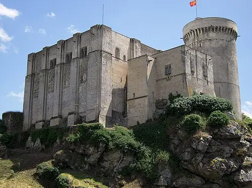
- Château Guillaume-le-Conquérant: the castle on the rock where William was born around 1027/28 – today’s square keep dates from the 12th century – plus the round Talbot Tower from the 13th century; the modern restoration with concrete and glass elements is controversial and for that very reason interesting.
- Fontaine d’Arlette in the Val d’Ante below the castle wall – according to tradition the spot where Duke Robert first saw Arlette, the tanner’s daughter and William’s mother.
- Mémorial des civils dans la guerre in the old town: a museum about the life of the civilian population in the Second World War – in August 1944 Falaise lay at the centre of the pocket and was largely destroyed.
- CampingSpirit overnight tip
-
Official campsite or RV park: Camping municipal du Château in the Val d’Ante directly below the castle, with electric hook-ups and sanitary facilities, open in season. Next door is the Camping-Car Park network aire with just under 20 pitches, electricity and water/waste services; access with the network’s card, which you get at the terminal. From both sites it is only a few minutes’ walk to the castle.
Free camping or nature tip (where legal): The castle is a Monument historique; within a 500-metre radius, so practically throughout the old town, camping is prohibited anyway. As the campsite and aire lie right at the foot of the rock, there is no reason to spend the night in car parks in town.
- Insider tip for campers
- Fill up and shop before leaving Caen: the large supermarkets on the Périphérique have service points and GPL pumps, which become rarer in the countryside. Caen city centre inside the Périphérique is a low-emission zone – more on this in the country practicalities. On the castle square in Falaise stand the equestrian statue of William and the statues of the first six dukes; the light there is most beautiful in the early evening.
2Stage 2: Falaise to Clécy via Pont-d’Ouilly (approx. 45 km)
- The drive
- Westwards on departmental roads through the hill country between plain and bocage, then down into the Orne valley to Pont-d’Ouilly at the confluence of the Orne and the Noireau. From there the road follows the river north to Clécy, sometimes high above, sometimes down by the water. Winding, partly narrow and with short, steep ramps; oncoming traffic in the sunken lanes means pulling into gateways. Around 1 hour of pure driving time, more with detours to the Pain de Sucre.
- Highlights & must-sees
- Pont-d’Ouilly: the old stone bridge over the Orne, the weir and the riverside path where canoes land in summer.
- Pain de Sucre near Clécy: the cone-shaped hill above the Orne loop, reached via the narrow Route des Crêtes; from the viewpoint you look down on the viaduct, the course of the river and the rock faces on the opposite slope.
- Rochers des Parcs at the hamlet of Le Vey: climbing crags directly above the river, which you can watch from the riverside path; next to them canoe and kayak hire for a stretch on the Orne.
- CampingSpirit overnight tip
-
Official campsite or RV park: In Clécy the municipal aire is on the Rue du Stade: only about five pitches, free to stay, free waste disposal, fresh water with tokens from shops in the village, no electricity. With hook-up and sanitary facilities you stay at Camping Les Rochers des Parcs on the bank of the Orne in Le Vey, open in season. Alternative further south: the Pont-d’Ouilly aire on the bank of the Orne with around 45 pitches separated by hedges, electricity and water/waste services, charged per 24 hours and, according to the operator, open roughly from February to November.
Free camping or nature tip (where legal): The Suisse Normande is touristy and small; municipalities and the department steer motorhomes to the aires. Walkers’ car parks on the Route des Crêtes and at the Pain de Sucre are tight and not intended for overnight stays. If you want to stay free, do so in the bocage away from the river valley, only in designated car parks and without camping behaviour.
- Insider tip for campers
- The Route des Crêtes to the Pain de Sucre is awkward for long and tall vehicles, and turning places are rare. Vehicles over about 7 metres are better left in Clécy; the footpath over the bridge at Le Vey and up to the viewpoint is steep but short. Canoe trips on the Orne start in Pont-d’Ouilly or Clécy, with return transport by the hire companies; they are cancelled when the river is high in spring.
3Stage 3: Clécy to Domfront via the Roche d’Oëtre (approx. 80 km)
- The drive
- Back to Pont-d’Ouilly and on south through the hills to the Roche d’Oëtre, then via Athis-de-l’Orne to Flers and on the D962 through the bocage to Domfront. Winding and narrow as far as Flers, well built from Flers onwards. Domfront sits on a rocky spur: the upper town is cramped, motorhomes park below. Around 1.75 hours of pure driving time.
- Highlights & must-sees
- Roche d’Oëtre: a rock pulpit 118 metres above the gorge of the Rouvre, with a view over a wooded valley reminiscent of upland mountains; an Espace naturel sensible of the Orne department with a visitor pavilion and waymarked paths through the gorge, such as the Sentier du granite to the Maison de la Rivière et du Paysage.
- Domfront: the castle ruins on the rock above the Varenne, built up into a strong fortress under Henry I Beauclerc, with a view far across the bocage to the hills of the Passais.
- Église Notre-Dame-sur-l’Eau down by the Varenne, a Romanesque church from the 11th century, and as a contrast up in the old town the concrete church of Saint-Julien from the 1920s and 1930s with mosaics in neo-Byzantine style.
- CampingSpirit overnight tip
-
Official campsite or RV park: Camping municipal du Champ Passais on the edge of Domfront below the old town, with electric hook-ups, sanitary facilities and water/waste services, open in season; from there a footpath leads up into town. A few kilometres outside, the campsite at the Manoir de la Nocherie takes guests – check facilities and opening times beforehand.
Free camping or nature tip (where legal): Parking in the visitor car park at the Roche d’Oëtre is no problem during the day; it is not meant for overnight stays, and the site is protected. Around Domfront, pear and cider farms are good alternatives: through France Passion and on request with producers you can spend a night in an orchard – phone ahead and respect the farm rules.
- Insider tip for campers
- Do not drive the motorhome into Domfront’s upper town; the lanes are narrow and steep. In the Domfrontais the drink is poiré (sparkling perry, AOP Poiré Domfront), not cider – and Calvados Domfrontais must contain at least 30 per cent pears and is distilled in a column still. Taste at the end of the driving day, not before. Flers has the stage’s large supermarkets with a filling station.
4Stage 4: Domfront to Bagnoles-de-l’Orne (approx. 25 km)
- The drive
- A short stage east through the bocage and into the Forêt des Andaines, a large state forest of beech, oak and pine. The roads are good, the forest sections shady; watch out for deer at dusk and for cyclists. Around 30 minutes of pure driving time – enough time for a morning in the forest and an afternoon in the spa town.
- Highlights & must-sees
- Lac de Bagnoles with the casino on its shore and above it the Roc au Chien rock; a short path leads to viewpoints over the town and the forest.
- Quartier Belle Époque: villas with turrets, half-timbered gables and ceramic decoration from around 1900; a signposted walk explains the architecture.
- Forêt des Andaines: walking trails and forest roads around Bagnoles, with small ponds and chapels; in autumn the deer rut and mushroom hunters.
- CampingSpirit overnight tip
-
Official campsite or RV park: The Bagnoles-de-l’Orne aire de camping-car on the Avenue du Château de Couterne, carrying the label of the AireServices network: around 30 large pitches with electricity, fresh water and waste disposal, charged, with shops, lake and casino within walking distance. Right next door is the La Vée campsite, a large site with electric hook-ups and full sanitary facilities, which has a long season because of the spa guests.
Free camping or nature tip (where legal): Bagnoles is a spa town with many guests and little space; motorhomes are clearly steered to the aire and campsite. Forest car parks in the Forêt des Andaines are state forest managed by the ONF: parking during the day yes, camping at night no – follow the signs, and no open fires in dry weather.
- Insider tip for campers
- Bagnoles is best experienced by bike: the Véloscénie cycle route from Paris to Mont-Saint-Michel passes through the area, partly on a former railway line. Besides spa treatments, the thermal baths also offer individual wellness sessions without a medical prescription. Fill and empty at the aire; as far as Alençon it is the most convenient station.
5Stage 5: Bagnoles-de-l’Orne to Alençon via Carrouges (approx. 55 km)
- The drive
- On departmental roads east through forest and pasture to Carrouges, then south-east through the Normandie-Maine regional park to Alençon. Wide country roads with little traffic; only the last kilometres in Alençon are urban. Around 1.25 hours of pure driving time.
- Highlights & must-sees
- Château de Carrouges: a brick château from the 14th to 17th centuries in a moat, with gatehouse, grand staircase and apartments; today run by the Centre des monuments nationaux.
- Maison du Parc naturel régional Normandie-Maine in Carrouges: information on walking trails, bocage and orchards of the region.
- Alençon: the Musée des Beaux-Arts et de la Dentelle with Point d’Alençon, a needle lace whose technique has been on the UNESCO list of intangible cultural heritage since 2010, plus the Gothic Basilica of Notre-Dame and the birthplace of Saint Thérèse.
- CampingSpirit overnight tip
-
Official campsite or RV park: Camping de Guéramé, the town of Alençon’s site on the bank of the Sarthe, around 1.5 kilometres from the centre, with electric hook-ups, sanitary facilities and waste disposal; along the riverside path on foot or by bike into the old town. Carrouges has a small municipal campsite on the edge of the village. For a quieter stay: the aire at Saint-Céneri-le-Gérei in the Alpes Mancelles, around 15 kilometres south-west of Alençon, has room for many motorhomes below the village.
Free camping or nature tip (where legal): The Château de Carrouges is a Monument historique, and the château park with its approaches is no place for the night. In Alençon the campsite is the obvious solution; staying overnight in city-centre car parks is not prohibited, but noisy and cramped.
- Insider tip for campers
- Saint-Céneri-le-Gérei, with its Romanesque church above a loop of the Sarthe, is one of the “Plus beaux villages de France” and, as an evening or morning outing from Alençon, the counterpart to the town. In Alençon leave the motorhome at the campsite: the old town is small, the streets narrow, and car parks without height barriers are scarce.
6Stage 6: Alençon to La Chapelle-Montligeon via Mortagne-au-Perche (approx. 65 km)
- The drive
- East on the N12, partly dual carriageway, over the ridge into the Perche. Beyond Le Mêle-sur-Sarthe the land becomes more rolling, with woods and hedgerows framing the fields. Mortagne sits on a hill; afterwards narrow departmental roads lead south-east down into the valley to La Chapelle-Montligeon. Around 1.25 hours of pure driving time.
- Highlights & must-sees
- Mortagne-au-Perche: the old capital of the County of Perche with the Porte Saint-Denis, the late Gothic church of Notre-Dame and the Musée Alain, dedicated to the philosopher born in Mortagne; the town is known for its boudin noir.
- The view from the gardens on the edge of the upper town south over the hills of the Perche.
- Basilica of Notre-Dame de Montligeon: a large neo-Gothic pilgrimage church from the early 20th century, surprisingly massive in a small forest village.
- CampingSpirit overnight tip
-
Official campsite or RV park: Camping Les Bruyères in La Chapelle-Montligeon on the edge of the Réno-Valdieu forest, a simple municipal site with electric hook-ups, open only for a short summer season (roughly mid-June to mid-September) – outside that, use the aire in Longny instead. Alternative further east: the Camping-Car Park network aire in Longny-au-Perche with around 20 pitches, electricity and water/waste services, on the edge of town next to the campsite.
Free camping or nature tip (where legal): The Perche is sparsely populated, and many villages have a car park on the edge of town where a quiet night without camping behaviour is tolerated – follow the signs. The regional park has no free-camping rules of its own, but forests such as Réno-Valdieu and Bellême are state forest: forest tracks are mostly closed to motor vehicles.
- Insider tip for campers
- Make use of the market in Mortagne on Saturday morning (check the day beforehand) – sausage, cheese and cider from the area. Mortagne’s upper town has steep one-way streets; park on the edge and walk. From here on the departmental roads are often narrow and without a centre line, with tractors and timber lorries.
7Stage 7: La Chapelle-Montligeon to Nogent-le-Rotrou via Bellême and Courboyer (approx. 65 km)
- The drive
- A stage through the heart of the Parc naturel régional du Perche: on forest roads through the Forêt de Bellême to Bellême, then east to the Domaine de Courboyer near Nocé and via Saint-Cyr-la-Rosière down into the valley of the Huisne to Nogent-le-Rotrou, which already belongs to the Eure-et-Loir department. Hilly, winding, with sunken lanes and short climbs, but no real pinch points outside the villages. Around 1.5 hours of pure driving time.
- Highlights & must-sees
- Domaine de Courboyer near Nocé: a manor house from the second half of the 15th century with corner turrets, opposite it the Maison du Parc with an exhibition, walking trails over around 60 hectares and regular encounters with Percheron horses.
- Bellême with its town gate and the forest: the Forêt de Bellême is considered one of the most beautiful oak forests in France; at the Étang de la Herse there is a spring with ancient inscriptions.
- Saint-Cyr-la-Rosière: the Sainte-Gauburge priory with the Écomusée du Perche, which presents agriculture, crafts and the history of the Percherons; nearby are manor houses such as L’Angenardière, which you can usually only see from outside.
- CampingSpirit overnight tip
-
Official campsite or RV park: Camping municipal des Viennes in Nogent-le-Rotrou on the Huisne, with electricity and sanitary facilities, open in season; right next to it is the Aire des Viennes with water/waste services, both a few minutes’ walk from the centre. For a night in the middle of the Perche: Camping du Perche Bellêmois on the edge of Bellême (roughly April to mid-October, with electric hook-ups and water/waste services for motorhomes) or the simple aire at Gué-de-la-Chaîne west of Bellême.
Free camping or nature tip (where legal): The manor houses of the Perche are mostly privately owned and many are protected as Monuments historiques; access lanes and farm entrances are not car parks. Stop at the roadside for a photo, do not stay overnight. Small municipal aires such as the one in Saint-Germain-de-la-Coudre are the quiet alternative.
- Insider tip for campers
- Most manor houses open at most for the Journées du patrimoine or on request; the Maison du Parc in Courboyer has maps of the manor routes to drive. You will also see Percheron horses in pastures throughout the region – do not feed them, do not enter paddocks. In Nogent the climb to the Château Saint-Jean above the town is worthwhile; the lanes below are unsuitable for motorhomes.
8Stage 8: Nogent-le-Rotrou to Lisieux via Le Pin-au-Haras, Camembert and Vimoutiers (approx. 145 km)
- The drive
- The longest stage, easily split: via Rémalard and Mortagne back west, then on departmental roads across the Merlerault plateau to the Haras du Pin. From there north into the Pays d’Auge: the landscape becomes hillier, half-timbered farms and apple meadows line the road to Camembert and Vimoutiers. Finally on the D579 through the valley of the Vie via Livarot to Lisieux. Around 2.5 hours of pure driving time; if you want to travel slowly, stay overnight in Vimoutiers and drive the last 30 kilometres or so the next morning.
- Highlights & must-sees
- Haras national du Pin: the “Versailles of the horse”, an 18th-century stud with château, stables and wide paddocks; guided tours and shows with Percherons, Cobs normands and sport horses.
- Camembert and Vimoutiers: the village the cheese is named after, with its Maison du Camembert (museum and shop, open seasonally, closed in winter), and the small town with the monument to Marie Harel, who according to tradition invented the cheese around 1791; Camembert de Normandie AOP is made from raw milk and ladled into moulds.
- Livarot on the D579: at the Village Fromager of the Graindorge cheese dairy you look through glass galleries into production – best in the morning from Tuesday to Saturday – then Lisieux with the Basilica of Sainte-Thérèse, one of the largest churches of the 20th century in France.
- CampingSpirit overnight tip
-
Official campsite or RV park: In Vimoutiers the aire de service and the small La Campière campsite are close to the centre – the quiet overnight stop in the heart of cheese country. Lisieux has a designated motorhome car park within walking distance of the basilica and the Camping municipal de la Vallée on the northern edge of town, with electricity and sanitary facilities, open in season.
Free camping or nature tip (where legal): In the Pays d’Auge many cider and Calvados farms take France Passion members for one night; this is the nicest way to stay here, with a view of apple meadows and cows. The stud grounds in Le Pin are a Monument historique, and the car parks there are for daytime visitors only.
- Insider tip for campers
- Camembert and Livarot smell strongly; an airtight box in the fridge spares the camper a week of cheese aroma. Calvados Pays d’Auge is double-distilled in a pot still – at the tasting, ask about the difference from the Domfrontais of day three. Keep Lisieux short: the basilica is impressive, the town itself busy and full of traffic; for the coast and onward travel the A13 and A28 are close by.
Camping practice & local rules
Wild camping & overnight parking
- Parking is not camping: a motorhome counts as a vehicle and may stand wherever parking is permitted, including overnight and for at most seven days in the same place, unless a municipal order (arrêté municipal) or a sign says otherwise. Levelling jacks, ramps, awning, table and chairs or draining water count as camping and are only allowed on campsites and aires.
- Wild camping is prohibited in listed landscapes (Sites classés), within a 500-metre radius of Monuments historiques and near drinking water catchments. On this route that affects the castles of Falaise and Domfront, the châteaux of Carrouges and Nogent, the Haras du Pin, many churches and numerous manor houses of the Perche. Nature sites such as the Roche d’Oëtre and the state forests (Andaines, Bellême, Réno-Valdieu) are accessible during the day but are not places to spend the night.
- The hinterland is more relaxed than the coast: blanket motorhome bans are rare, and many municipalities run small, sometimes free aires. In popular places such as Clécy, Bagnoles or Bellême, signs and aires clearly direct the traffic.
- France Passion arranges overnight stays with producers – in the Domfrontais at perry and Calvados farms, in the Perche at farms, in the Pays d’Auge at cheese dairies and cider farms; annual membership required, phone ahead. Apps: park4night, Campercontact, Caramaps; the tourism websites of the Calvados, Orne and Eure-et-Loir departments and of the Parc naturel régional du Perche list the municipal aires.
Waste disposal & supplies
- You will find water and waste services in Falaise (Camping-Car Park), Clécy and Pont-d’Ouilly, Domfront, Bagnoles-de-l’Orne (AireServices), Alençon (campsite), Longny-au-Perche, Nogent-le-Rotrou, Vimoutiers and Lisieux, among other places. Camping-Car Park aires work with their own access card, AireServices bollards mostly with a bank card.
- Many small village aires in the Perche and the bocage have only a tap and a drain, sometimes without cassette emptying; the water supply is often turned off in winter. Empty cassettes and grey water only at service points, never into ditches, streams or hedges.
- Drinking water from taps marked “eau potable”; at cemeteries and wash places the sign often reads “eau non potable”. In dry summers the prefectures of Calvados and Orne impose water restrictions, which can also affect aires.
- Gas: French exchange cylinders (butane, propane) are available at filling stations and supermarkets; foreign cylinders are not exchanged. GPL pumps for filling refillable cylinders (Dish or Euronozzle adapter) are more likely in Caen, Flers, Alençon and Lisieux than in the countryside; fill up before the Perche.
Vehicle size & traffic rules
- Speed limits: motorhomes up to 3.5 t and vehicle combinations up to 3.5 t gross combined weight drive like cars – 130 km/h on motorways, 110 on expressways with separate carriageways such as the N158 Caen–Falaise, 80 on country roads (90 where signposted), 50 in built-up areas, in rain 110/100/80. Motorhomes over 3.5 t up to 12 t: 110 on motorways, 100 on expressways with separate carriageways, 80 on all other roads, even where cars may do 90, with a speed-limit disc on the rear. Combinations over 3.5 t: 90 on motorways and expressways with separate carriageways, 80 on other roads.
- Vehicles over 3.5 t, explicitly including motorhomes, need “Angles morts” (blind spot) stickers on the sides and rear; not having them costs €135.
- Tolls: the route itself runs on toll-free national and departmental roads. On the way in, the A13 and A14 from Paris are paid as “Flux libre” without barriers – within 72 hours online by number plate, otherwise a €90 flat surcharge followed by a fine; the A28 Rouen–Alençon–Le Mans is also tolled. Classes: class 2 for vehicles up to 3.5 t over 2 and under 3 metres high, class 3 for two-axle vehicles from 3 metres high or over 3.5 t, class 4 for three or more axles over 3.5 t or from 3 metres.
- Low-emission zones: on 21 May 2026 the Conseil constitutionnel struck down the nationwide abolition of the ZFE; the zones remain in place, and each Métropole sets the classes itself. In Caen a ZFE applies inside the Périphérique, which since 1 January 2025 has excluded vehicles without a Crit’Air classification (cars first registered before 1997) around the clock; however, every vehicle needs the sticker there, including those with foreign number plates – order only via the official site certificat-air.gouv.fr. If you arrive via Paris, stricter rules apply inside the A86, and Rouen has its own ZFE too. Check the current situation before the trip.
- Blood alcohol limit 0.5, 0.2 for novice drivers – a real issue with poiré, cider, pommeau and Calvados on every corner; schedule tastings for the end of the driving day. Mobile phones and headphones at the wheel are prohibited; keep a high-visibility vest (mandatory for the driver) within reach and a warning triangle on board. A bike rack must not obscure the number plate and lights, otherwise use a light board with a repeater plate.
CampingSpirit packing & preparation checklist
- Bikes (touring or e-bike) with a lock – the Véloscénie and the railway-path routes around Bagnoles and Domfront, as well as the hilly back roads in the Perche, are best explored by bike.
- Levelling ramps: the aires in Clécy, Domfront and many Perche villages are sloping, and ramps belong only on aires and campsites, not in car parks.
- Airtight cheese box and padding for bottles: Camembert, Livarot and Pont-l’Évêque smell, and poiré and cider are under pressure.
- Waterproof walking shoes with good tread and a rain jacket for the paths at the Roche d’Oëtre, the Pain de Sucre and the forest tracks – slate and clay are slippery after rain.
- Gas adapter set and two full cylinders on arrival, because GPL pumps are rare in the Perche and the bocage.
- Binoculars for birds of prey above the Orne gorge and for the Percherons in distant pastures.
As of 2026-10. Closures, fees and booking rules change: check official sources before you go.