

In-depth guide · CampingSpirit
From the Cadillacs near Amarillo down into Palo Duro Canyon, via Claude and Silverton to the bison herd in Caprock Canyons State Park, through the ranch towns of Quitaque, Turkey and Matador to Lubbock and Post, and back to the Alibates flint at Lake Meredith: around 950 kilometres of high plains, escarpment and canyon country.
The spirit of the route
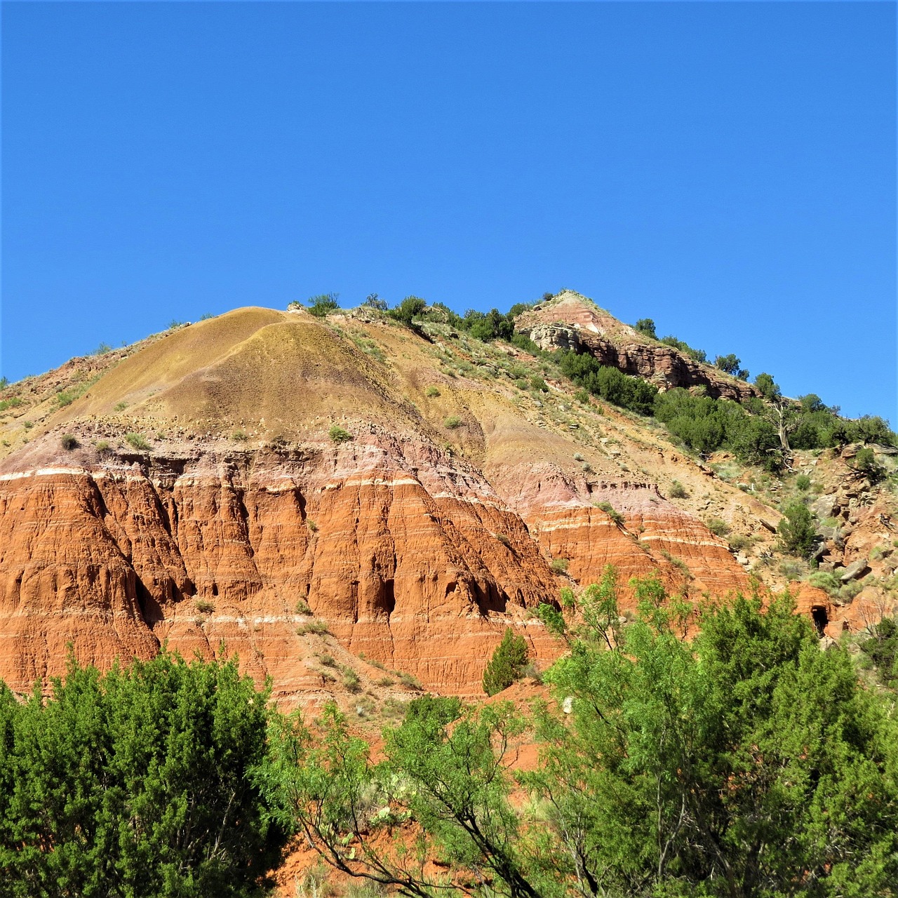
The Llano Estacado is so flat that you think you can see the curvature of the earth: wheat, cotton, wind turbines, grain elevators standing over the towns like church steeples. And then the plain tears open. Where rivers have eaten into the Caprock, red, yellow and violet-banded walls drop away, juniper clings to the slopes, and after thunderstorms brown water rushes over the fords on the valley floor. In the morning in Palo Duro Canyon you watch from the sliding door as the sun lights up the rock spires on the rim first; in Caprock Canyons bison graze between the campsites, and in the evening lightning flickers on the horizon from storm towers eighty kilometres away. The wind never quite stops. In between lie towns with one traffic light and a courthouse, cowboy history, Western swing from Turkey, rock ’n’ roll from Lubbock – and everywhere the saying that you don’t drive through here, you arrive.
Stage-by-stage plan
1Stage 1: Amarillo to Palo Duro Canyon State Park (approx. 75 km)
- The drive
- From Cadillac Ranch on the western edge of town along the I-40 and through Amarillo, then on the I-27 dead straight south for around 25 kilometres to Canyon and east on the TX-217 to the park entrance. Everything is flat at around 1,100 metres elevation until the canyon suddenly opens up: beyond the entrance gate, Park Road 5 descends in steep switchbacks to the valley floor. Pure driving time around an hour; with the museum and Cadillac Ranch it makes a full day. Fuel stations and supermarkets in Amarillo and Canyon; in the park only a small store.
- Highlights & must-sees
- Cadillac Ranch: ten 1974 Cadillacs buried nose-first, an installation by the artists’ collective Ant Farm, in a field on the southern frontage road of the I-40. Free access through a gate, and visitors are allowed to spray-paint. Motorhomes park at the edge of the frontage road; after rain the field is a mud hole.
- Route 66 in Amarillo: if you want to brush against the Mother Road, drive a stretch of Sixth Avenue with the historic district around San Jacinto – the CampingSpirit guide to Route 66 describes it in detail.
- Panhandle-Plains Historical Museum in Canyon on the campus of West Texas A&M University: the largest history museum in Texas, with fossils, firearms and saddles, a section on the oil industry, art of the Southwest and a reconstructed pioneer town. Allow three hours for a thorough visit; check opening times in advance.
- CampingSpirit overnight tip
-
Official campsite or RV park: Palo Duro Canyon State Park: the camping areas lie on the valley floor along Park Road 5. Hackberry (water, 20/30 A), Mesquite/Sagebrush (water, 30/50 A, some sites up to around 18 metres long) and Juniper (water, 30/50 A) are suitable for motorhomes; Fortress Cliff is a tent-only area, and trailers and motorhomes are not permitted there. Restrooms with showers by the loops. Reservations through the central Texas State Parks system; on top of the site fee comes the daily entrance fee per person. In spring and autumn, weekends book up early.
Free camping or nature tip (where legal): Around Amarillo and Canyon there is no public land for free camping; it is all private land, and on the canyon rim fences and signs prohibit entry. In the state park you only stay overnight on your booked site. The first legal free sites are in Lake Meredith National Recreation Area north of Amarillo (see last stage).
- Insider tip for campers
- Before heading down into the canyon, fill up with fuel and stock up on water in Canyon. Drive Park Road 5 down and back up in a low gear with a long rig and don’t overheat the brakes. For day visits at weekends and on public holidays, reserve a Day Pass in advance – guests with a booked campsite don’t need an additional one.
2Stage 2: Palo Duro Canyon State Park to Palo Duro Canyon State Park (approx. 30 km)
- The drive
- A day in the second-largest canyon in the USA: around 190 kilometres long and up to around 240 metres deep, carved by the Prairie Dog Town Fork of the Red River. Park Road 5 runs as a loop across the valley floor and crosses the river at several low-water crossings – after heavy rain these and the hiking trails are closed, and the campgrounds can then sometimes only be reached via an alternative road. Up on the rim are the visitor centre and viewpoints; the drives in the park are short, the days long.
- Highlights & must-sees
- Lighthouse Trail: the classic hike to the “Lighthouse” rock formation, a free-standing tower of red clay and sandstone; around 9 to 10 kilometres there and back, mostly flat but without shade. In summer start at dawn and carry at least three to four litres of water per person – park staff have to rescue exhausted hikers every year.
- Visitor centre on the canyon rim: a stone building by the Civilian Conservation Corps from the 1930s with a small museum and the finest view into the gorge. From here and from the CCC Trail you can see the coloured layers of the walls – the locals call the striped slopes Spanish Skirts.
- Pioneer Amphitheater: in summer the open-air stage at the foot of a canyon wall hosts the musical “TEXAS” about the settlement history of the Panhandle, with horses, fireworks and thunderstorms from nature as an encore. Check the season and tickets on the organisers’ website.
- CampingSpirit overnight tip
-
Official campsite or RV park: Second night on the same site in the park. If you are going to the musical in the evening, Sagebrush is the shortest walk, as it lies closest to the amphitheatre.
Free camping or nature tip (where legal): In the park there are hike-in backcountry sites by permit only (subject to availability, no water, open fires prohibited). For vehicles there is no free camping. Towards the end of the year, parts of the backcountry are temporarily closed for controlled hunts – check current notices on the park’s page.
- Insider tip for campers
- When thunderstorms are forecast, don’t hike on the valley floor and don’t drive through any crossing with water on it – flash floods come out of side canyons, often under a blue sky above your own head. In the morning check the weather situation with the National Weather Service Amarillo. In summer the canyon floor is noticeably hotter than the high plains.
3Stage 3: Palo Duro Canyon State Park to Caprock Canyons State Park (approx. 170 km)
- The drive
- From the park via Farm-to-Market roads (finally the FM 1151) east to Claude, then south on the TX-207: the road runs across the plain and then plunges with steep downgrades and curves into the valley of the Prairie Dog Town Fork, the eastern part of Palo Duro Canyon, crosses the river and climbs back up the other side – one of the most impressive stretches of road in the region. On across the high plains to Silverton and east on the TX-86 to Quitaque, from there a few kilometres north on the FM 1065 to the park. Pure driving time around 2.5 hours; fuel stations in Claude, Silverton and Quitaque, nothing in between.
- Highlights & must-sees
- Claude: county seat of Armstrong County with water tower, grain elevators and courthouse; in 1962 Hollywood filmed “Hud” with Paul Newman here. Around 20 kilometres east on the US-287, in the community of Goodnight, the Charles Goodnight Historical Center commemorates the rancher who preserved the founding herd of today’s Caprock Canyons bison.
- TX-207 canyon crossing: pull-outs up on the edges offer wide views into the red-and-white-banded gorge, which is wild and uninhabited here – only cattle, mesquite and juniper.
- Silverton: tiny county seat of Briscoe County on the edge of Tule Canyon. In this area the 1874 battle in Palo Duro Canyon brought the wars of the Comanche, Kiowa and Cheyenne on the Southern Plains to an end.
- CampingSpirit overnight tip
-
Official campsite or RV park: Caprock Canyons State Park: Honey Flat is the area for motorhomes, with water and electricity (30 or 50 A depending on the site) and a restroom, near Lake Theo. In addition there are walk-in sites with water nearby at Lake Theo, basic tent sites without drinking water and without showers (Little Red, South Prong), hike-in sites, equestrian sites and overflow sites. Individual loops are temporarily closed for repairs; check the current status when booking through the Texas State Parks system.
Free camping or nature tip (where legal): Between Claude and Quitaque there is only private land and ranches; there is no public land for free camping. Small communities such as Quitaque or Turkey sometimes have simple pitches on the edge of town – only stay where it is expressly permitted.
- Insider tip for campers
- Take the TX-207 downgrades slowly with a heavy vehicle, and don’t drive into the canyon in thunderstorms or fog; in strong winds crosswinds also make the curves tight. Refuel and shop in Claude or Silverton – the choice in Quitaque is small. Mobile reception in the park is patchy.
4Stage 4: Caprock Canyons State Park to Caprock Canyons State Park (approx. 40 km)
- The drive
- A rest day among red gorges below the Caprock Escarpment, where the Llano Estacado breaks off to the Rolling Plains. The park road leads from the entrance past the prairie dog town to Lake Theo and the trailheads; the bison roam freely across the whole area and across the road too. For the Trailway, drive to one of the trailheads on the country roads around Quitaque.
- Highlights & must-sees
- The State of Texas bison herd: descendants of the animals that Charles Goodnight and his wife Mary Ann saved from extinction in the 19th century, the official State Bison Herd since 2011. Keep at least 50 yards (around 45 metres) away, more is better – bison are fast and unpredictable, especially during the rut in late summer and with calves in spring.
- Hiking trails in the canyon: Lower and Upper South Prong, the Canyon Loop and the climb to Haynes Ridge Overlook with views over the rugged badlands to the plain; steep, rocky and shadeless. At Lake Theo, a short walk by the water.
- Caprock Canyons Trailway: around 103 kilometres (64 miles) of former Fort Worth and Denver Railway line between the high plains near South Plains and Estelline, unpaved, for hiking, cycling and horse riding. The highlight is the roughly 160-metre-long Clarity Tunnel, home from late April to mid-October to a colony of Mexican free-tailed bats – don’t disturb the animals and follow the park’s guidance on the tunnel.
- CampingSpirit overnight tip
-
Official campsite or RV park: Second night at Honey Flat. Lake Theo is good for fishing and paddling; swimming at your own risk.
Free camping or nature tip (where legal): Along the Trailway there are basic fee-paying sites for cyclists and hikers (no drinking water, no campfires); for vehicles there is no free camping, and the trailheads are not intended for overnight stays. Trespassing on the surrounding private land is prohibited.
- Insider tip for campers
- For cycling on the Trailway, bring wide tyres and spare inner tubes: the gravel is deep in places, and thorns from mesquite and cacti are common. There is hardly any water on the Trailway. Bison like to walk through the campgrounds at night – leave nothing edible outside and use a torch after dark.
5Stage 5: Caprock Canyons State Park to Lubbock (approx. 220 km)
- The drive
- Back to Quitaque and east on the TX-86 through red country and mesquite to Turkey, then south on the TX-70 to Matador. From there west on the US-62/70: near Roaring Springs and Dougherty the road climbs the Caprock Escarpment onto the Llano Estacado, after which it runs dead straight via Floydada and through cotton fields to Lubbock. Two-lane country roads, little traffic, speed limit mostly 70–75 mph. Pure driving time around 2.5 hours; fuel stations in Turkey, Matador, Floydada and Lubbock.
- Highlights & must-sees
- Turkey: the Bob Wills Museum, with instruments, photos and memorabilia, tells the story of the “King of Western Swing”, who grew up in this area; a monument stands in front of it. In spring Bob Wills Day fills the town with fiddle music and dancing. The historic Hotel Turkey from 1927 is part of the townscape.
- Matador: county seat of Motley County, named after the Matador Land and Cattle Company, a Scottish-financed ranching enterprise that from 1882 built up one of the largest cattle empires on the Plains here. Small, quiet, with a courthouse and old shopfronts.
- Climb onto the Caprock west of Matador: at the edge of the high plains it is worth stopping to look back over the Rolling Plains – here you can see how sharply the Llano Estacado ends.
- CampingSpirit overnight tip
-
Official campsite or RV park: Buffalo Springs Lake south-east of Lubbock: a recreation area on a reservoir in the canyon of the Double Mountain Fork, run by Lubbock County Water Control and Improvement District No. 1, with sites with electricity (20/30/50 A) and water, tent sites, showers and a dump station; on top of the site fee there is a per-person entrance fee at the gate. Check current operations, facilities and lengths with the operator in advance. Alternatives are private RV parks in Lubbock, some with full hook-ups.
Free camping or nature tip (where legal): Lubbock and the towns along the route have no public land for free camping. Matador and Turkey sometimes have simple municipal pitches – ask locally. In Lubbock, don’t stay overnight on streets or in public car parks.
- Insider tip for campers
- On the high plains there is often a gale-force westerly wind; with a high-sided vehicle expect crosswinds on the north–south sections and heed wind warnings. In spring, dust storms can cut visibility to a few metres within minutes – then lights on, pull over to the right, get completely off the road and take your foot off the brake so that vehicles behind don’t steer towards your brake lights.
6Stage 6: Lubbock to Post (approx. 140 km)
- The drive
- A day in Lubbock and a detour to the south-east: on the US-84 across the high plains until, just before Post, the road leads down the Caprock edge – with wide views over the reddish hills of Garza County. Back the same way, or north on the TX-207 and west on the US-82. Four lanes as far as the edge, speed limit up to 75 mph. Pure driving time for the round trip around 1.5 hours.
- Highlights & must-sees
- Buddy Holly Center in Lubbock’s Depot District: in the old station of the Fort Worth and Denver South Plains Railway, with guitars, stage clothes and the famous black glasses of the musician, who died in 1959 aged 22. Opposite stand the Buddy Holly statue and the West Texas Walk of Fame. Also worthwhile are the American Windpower Center with more than a hundred historic windmills and the National Ranching Heritage Center of Texas Tech University with ranch buildings in the open air.
- Texas High Plains wineries: most of the grapes for Texas wine grow on the high plains around Lubbock. Llano Estacado Winery south of town, founded in 1976, is one of the pioneers; McPherson Cellars pours in a converted Coca-Cola bottling plant in the Depot District. Tastings have their own hours – if you are driving, taste sparingly.
- Post: founded in 1907 by the cereal manufacturer C. W. Post as a model settlement at the foot of the Caprock, with a wide main street, cinemas and shops from its early years and the Garza County Historical Museum in the former sanatorium.
- CampingSpirit overnight tip
-
Official campsite or RV park: Second night at Buffalo Springs Lake or at a private RV park in Lubbock. If you want to stay further south, you will find simple private RV parks in Post and at Lake Alan Henry; ask about hook-ups in advance.
Free camping or nature tip (where legal): No free camping in Lubbock or Post. Lake Alan Henry south-east of Post belongs to the City of Lubbock; camping there only in designated areas, check the rules in advance.
- Insider tip for campers
- The Buddy Holly Center and the Depot District are easy to reach with a large vehicle: there is room to park on the streets at the edge of the district. Shop and fill up with propane in Lubbock – on the final stage via Amarillo to Lake Meredith there is little outside the cities.
7Stage 7: Lubbock to Lake Meredith (approx. 270 km)
- The drive
- On the I-27 dead straight north for around 190 kilometres via Plainview and Tulia, through cotton, wheat and feed corn to Amarillo, then north-east on the TX-136 to the Canadian River. Shortly before Fritch, the access road to Alibates Flint Quarries turns off; the lake lies in the deeply cut canyon of the Canadian, invisible from the plain. Pure driving time around 3 hours; fuel stations at regular intervals along the I-27, none in the recreation area.
- Highlights & must-sees
- Alibates Flint Quarries National Monument: for around 13,000 years people quarried the colourful red-, blue- and white-banded flint here, from which Clovis points and tools were traded far across the Plains. The quarries are only accessible on National Park Service guided tours – around two hours, about three kilometres, strenuous and with a good 50 metres of elevation gain; reservations are mandatory (by phone, contact on nps.gov), and tours are cancelled in heat, storms, thunderstorms or weather warnings.
- Lake Meredith: reservoir behind Sanford Dam with limestone ledges, juniper and coves. The water level fluctuates strongly over the years; boat ramps are open or closed depending on the level.
- Fritch: small town on the southern edge of the recreation area with shopping and the Lake Meredith Aquatic and Wildlife Museum.
- CampingSpirit overnight tip
-
Official campsite or RV park: Lake Meredith National Recreation Area: Sanford-Yake on the east shore has ten RV sites with electricity (20/30/50 A) and water, which are the only ones that charge a fee (check how to reserve on nps.gov), plus further basic sites, showers and a dump station nearby. Fritch Fortress sits high above the lake with a paved access road, pull-through sites and drinking water, showers seasonal. Maximum stay 14 days in 30 days.
Free camping or nature tip (where legal): All sites in Lake Meredith National Recreation Area apart from the ten RV sites at Sanford-Yake are free and first-come, first-served: for example Blue West, Harbor Bay, Cedar Canyon or Plum Creek, mostly with vault toilets and no drinking water. Digging and levelling are prohibited, fires only in existing grills and fire rings; observe burn bans.
- Insider tip for campers
- Drinking water is only available at Fritch Fortress, Sanford-Yake and the restroom at Cedar Canyon; the dump stations offer no drinking water. Be at Alibates in good time for the tour – it starts punctually, and in summer earlier in the morning than the rest of the year. For the return journey: Amarillo is only an hour away.
Camping practice & local rules
Wild camping & overnight parking
- The Texas Panhandle consists almost entirely of private land; dispersed camping in the sense of BLM or forest land does not exist on this route. The legal free alternative is the basic sites in Lake Meredith National Recreation Area, which, apart from the RV sites at Sanford-Yake, are allocated free of charge on a first-come, first-served basis (maximum stay 14 days in 30 days).
- In state parks you only stay overnight on booked sites. Palo Duro Canyon and Caprock Canyons are reserved through the central Texas State Parks system, for most sites up to five months in advance; on top of the site fee come daily entrance fees per person. For day visits to popular parks at weekends and on public holidays, reserve a Day Pass in advance, otherwise you may be turned away at the gate when the park is full. A Texas State Parks annual pass saves the entrance fees.
- Federal areas: Lake Meredith and Alibates belong to the National Park Service; since 2026, visitors without US residency have in some cases paid higher fees and surcharges at heavily visited US national parks – check current amounts on nps.gov.
- TxDOT rest areas are for taking a break; stays are limited to 24 hours, and tents and set-ups are not permitted. Supermarket car parks only with the store’s permission; many cities prohibit overnight stays by ordinance.
- Fire: the Plains often suffer from drought and strong wind, and the counties then impose burn bans, which also cover campfires in fire rings; in the state parks usually only charcoal and enclosed gas stoves are then allowed. Check the status with the campground or the Texas A&M Forest Service. Prairie fires spread at terrific speed in wind.
- Apps: iOverlander, Campendium, The Dyrt, Recreation.gov and the Texas State Parks reservation site; Park4Night is hardly used here.
Waste disposal & supplies
- Dump stations: in Palo Duro Canyon and Caprock Canyons state parks according to campers’ reports (confirm when booking, ask for the location at check-in), at Buffalo Springs Lake, at Fritch Fortress and Sanford-Yake on Lake Meredith (without drinking water), and at private RV parks and some large truck stops along the interstates.
- Drinking water: at the sites on the state park campgrounds; at Lake Meredith only at Fritch Fortress, Sanford-Yake and Cedar Canyon. Tap water is drinkable, on the high plains sometimes hard and mineral-rich – a filter protects the water heater and the taste.
- Empty grey water and chemical toilets only at dump stations; draining onto the ground or into watercourses is prohibited and punished with fines.
- Propane: fuel stations, DIY stores and farm supply stores in Amarillo, Canyon and Lubbock fill US cylinders; in the small towns often not. European cylinders are generally not filled.
- Electricity: Palo Duro offers 20/30 or 30/50 A depending on the area, Honey Flat in Caprock Canyons 30 or 50 A depending on the site; in summer air conditioners run constantly – on 30 A sites don’t run high-draw appliances at the same time.
- Fuel and shopping: large supermarkets only in Amarillo, Canyon and Lubbock; in Claude, Silverton, Quitaque, Turkey, Matador, Post and Fritch small stores and fuel stations with limited opening hours, often closed on Sundays.
Vehicle size & traffic rules
- Speed limits: up to 75 mph on the I-27 and the I-40, on two-lane US and state highways mostly 70–75 mph during the day, considerably less through towns; there is no separate limit for motorhomes or rigs. On Farm-to-Market roads expect farm machinery, cattle and wildlife, especially at dusk and dawn.
- Tolls: there are no toll roads in the Panhandle or around Lubbock. Texting while driving is banned throughout Texas, and in school zones so is using a handheld phone.
- Dimensions: in Texas the general limits are 45 feet (13.7 metres) length for motorhomes and 65 feet (19.8 metres) for combinations; many sites in the state parks are shorter – check the length per site when booking. The access roads into the canyons (Park Road 5, TX-207) are steep and winding.
- Severe weather: the Panhandle lies in Tornado Alley. From April to June supercells bring tornadoes, golf-ball-sized hail and heavy rain; in summer heat thunderstorms follow with lightning strikes on the treeless plain. Check National Weather Service warnings (Amarillo and Lubbock offices) daily; in a tornado warning leave the motorhome and go into a solid building or the campground’s storm shelter.
- Flash floods: in Palo Duro Canyon, Caprock Canyons and at Lake Meredith, thunderstorms further upstream can trigger flood waves within a short time. Never drive through low-water crossings when water is flowing over them (“Turn Around, Don’t Drown”), and when warnings are in force don’t hike or park in creek beds. After heavy rain the parks close trails and roads, sometimes for days.
- Heat and wind: from June to August daytime highs are often above 35 °C, higher on canyon floors, with very dry air – you lose more water than you notice. Schedule hikes for the early morning hours. Wind is the normal state of affairs, with dust storms in spring. In winter cold fronts (“Northers”) bring temperature drops of more than 20 degrees within a few hours, blizzards and black ice, during which the I-40 and the I-27 may be closed. Best time to travel: mid-September to early November and April to May.
- Wildlife: the bison in Caprock Canyons are the most dangerous animals on the route – keep at least 50 yards away. Prairie areas are home to rattlesnakes, especially on warm evenings on trails and rocks; wear shoes and carry a torch. There are also fire ants, scorpions and, in autumn, migrating tarantulas, which are harmless.
- Emergency: 911. Mobile coverage is good on the interstates and in the cities, patchy in the canyons and between Claude, Quitaque and Matador.
CampingSpirit packing & preparation checklist
- Water containers totalling at least 40 litres, and a hydration bladder or large bottles for hikes: on the Lighthouse Trail, in Caprock Canyons and at Lake Meredith there is no water along the way, and the dry heat dehydrates you quickly.
- Weather radio with NOAA Weather Alert, or a severe weather app with National Weather Service warnings: in Tornado Alley and ahead of flash floods, the warning time is what counts, and there is often no mobile signal in the canyons.
- Heavy tent pegs, extra guy lines and an awning that can be retracted quickly: the wind on the high plains tears off awnings and porch tents, and gusts ahead of thunderstorms come without warning.
- Binoculars: for bison from a safe distance, prairie dogs, golden eagles and the bat flights at the Clarity Tunnel.
- Sturdy hiking boots and gaiters: the trails are rocky, cacti and mesquite thorns are everywhere, and rattlesnakes are not a rarity.
- Bicycle with wide tyres and a puncture kit: the Caprock Canyons Trailway with the Clarity Tunnel is best explored on two wheels.
As of 2026-10. Closures, fees and booking rules change: check official sources before you go.