

In-depth guide · CampingSpirit
From the craft town of Berea via Cumberland Falls, the gorges of the Big South Fork and Cumberland Gap to the coal mountains of Harlan and the gorge of the Breaks: around 1,000 kilometres of Appalachians off the beaten track.
The spirit of the route
South of Lexington, horse country ends abruptly: beyond Berea the Knobs rise, then the plateau, cut through by rivers that have carved deep into the sandstone. The route follows not a road but a landscape – rock shelters, arches, waterfalls, forests of hemlock, poplar and rhododendron, and in between, towns that were built by coal and then abandoned by it. In the morning you look out of the sliding door at mist lying in the valleys, hear coal trains shunting in the distance and, in the evening, the whip-poor-wills calling. You drive over the pass through which Daniel Boone led settlers west, sleep at campgrounds where black bears roam at night, and at the end you stand on the rim of a gorge whose depth locals call the “Grand Canyon of the South”. The roads are winding, the trucks heavy, the people friendly and the pace slow.
Stage-by-stage plan
1Stage 1: Lexington to Cumberland Falls State Resort Park (approx. 190 km)
- The drive
- From the southern edge of Lexington, head south on I-75; after around 60 kilometres the first range of hills appears near Berea. Continue on I-75 to the Renfro Valley exit near Mount Vernon and on to Corbin (Exit 25), then take US-25W and KY-90 into the park. The interstate is wide and climbs the edge of the plateau in long grades; the last few kilometres on KY-90 are winding and drop down towards the river. Driving time just under 2.5 hours. Fuel at every exit, large supermarkets in Berea, London and Corbin – the last good shop before the forest.
- Highlights & must-sees
- Berea: Kentucky’s craft town, shaped by Berea College, whose students pay no tuition and work in workshops in return. The Kentucky Artisan Center right off I-75 (Exit 77) has a large car park; galleries, weavers, potters and woodcarvers can be found on College Square and in the Old Town Artisan Village. If you want to hike: the Pinnacles in the Berea College Forest offer a short, steep climb with views over the Knobs; parking is tight for large vehicles.
- Renfro Valley: the “Renfro Valley Barn Dance”, one of the oldest country radio shows, has been performed here since 1939; the Kentucky Music Hall of Fame displays instruments and stories of the musicians from the mountains. A short stop right by the interstate – check the programme and opening hours in advance.
- Cumberland Falls: the Cumberland River plunges around 20 metres over a broad sandstone ledge; the viewing platforms are just a few steps from the car park. On clear nights around the full moon, a lunar rainbow (moonbow) forms in the spray; the park publishes the dates. Also described in detail in the CampingSpirit guide “Barrels, caves and moonbows” through Kentucky.
- CampingSpirit overnight tip
-
Official campsite or RV park: Cumberland Falls State Resort Park campground, with the Ridgeline and Clifty areas in the forest above the river: some sites with electric and water hookups, the rest for tents, bathhouse with showers, dump station. Sites are on the short side and only partly suitable for large motorhomes and long rigs; open seasonally, booked up early on moonbow dates and autumn weekends. Reservations through the Kentucky State Parks reservation system. If you start from Lexington the evening before: Kentucky Horse Park Campground with electric and water hookups and a dump station.
Free camping or nature tip (where legal): Overnight stays outside the campground are prohibited in the state park and along KY-90. In the surrounding Daniel Boone National Forest, dispersed camping is generally permitted, at a distance from roads, trails and recreation facilities; the London Ranger District can name suitable areas.
- Insider tip for campers
- For the moonbow, be on the platform an hour before moonrise and bring a tripod and a head torch with red light. When water levels are low in late summer or it is hazy, the moonbow does not appear – no guarantee. Fill up with fresh water in the park; some of the next campgrounds only have water spigots.
2Stage 2: Cumberland Falls to Blue Heron (Big South Fork) (approx. 90 km)
- The drive
- Take KY-90 west to US-27, then south via Parkers Lake and Whitley City to Stearns; from there take KY-1651 and KY-742 down to the Blue Heron Mining Community by the river. KY-90 and the access roads to Natural Arch and Yahoo Falls are narrow and winding, and KY-742 drops steeply into the valley at the end. Driving time around 2 hours, a full day with hikes. Fuel and supermarket in Whitley City.
- Highlights & must-sees
- Natural Arch Scenic Area (Daniel Boone National Forest) on KY-927 near Parkers Lake: a massive sandstone arch stands free above the forest; there is a quick view from the overlook at the car park, and the loop trail takes you underneath the arch. Picnic area, day-use fee possible.
- Yahoo Falls on KY-700 north-west of Whitley City: at around 34 metres, the highest waterfall in Kentucky, falling over a large rock shelter into an alcove. The paths behind the falls are short but steep; after dry spells it is only a trickle, after rain a veil. The access road is narrow and turning space is limited.
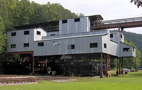
- Blue Heron Mining Community: the coal camp of the Stearns Coal and Lumber Company was abandoned in 1962; today open steel-frame “ghost structures” stand where the former buildings were, playing audio recordings of former residents. The coal tipple and the bridge over the Big South Fork have been preserved. Seasonally, the Big South Fork Scenic Railway runs here from Stearns; check the timetable.
- CampingSpirit overnight tip
-
Official campsite or RV park: Blue Heron Campground (National Park Service) on the upland above the mining community: around 45 sites in the forest, all with electric and water hookups, toilets and showers, dump station; open year-round, reservations required through recreation.gov. Simple alternative by the water: Alum Ford Campground near Yahoo Falls, with a few basic sites without hookups, only for short vehicles.
Free camping or nature tip (where legal): In the Big South Fork National River and Recreation Area, overnight stays are only permitted at the campgrounds or in the backcountry with a backcountry permit; they are prohibited on roads, in car parks and at trailheads. In the adjacent Daniel Boone National Forest, the dispersed camping rules of the Stearns Ranger District apply.
- Insider tip for campers
- Bears are active in the Big South Fork: at night, lock food, cool box, grill and rubbish inside a hard-sided vehicle and use bear-proof bins. There is practically no mobile coverage in the valley – save maps offline and fill up in Whitley City before you set off.
3Stage 3: Blue Heron to Bandy Creek (Tennessee) (approx. 130 km)
- The drive
- Back to Stearns and on US-27 across the state line to Oneida (Tennessee), then west on TN-297. The road drops in tight hairpins and on a steep gradient to the Leatherwood Ford bridge in the gorge and climbs just as steeply on the other side – use a low gear and don’t let your brakes overheat. For the Twin Arches, continue north on TN-154 and take Divide Road and Twin Arches Road (gravel) to the car park. Driving time around 2.5 hours. Fuel and shopping in Oneida.
- Highlights & must-sees
- Twin Arches: two joined sandstone arches that rank among the largest in the eastern USA; around 1.2 kilometres from the car park with stairs and ladders. The gravel road is easily passable for cars and vans but unsuitable for large motorhomes and rigs – leave your vehicle on TN-154 if there is no other option.
- Leatherwood Ford: bridge and riverbank at the bottom of the gorge with a short riverside path, picnic area and access to the Angel Falls Overlook (loop trail).
- Bandy Creek Visitor Center: maps, trail conditions, backcountry permits and information on horse and mountain bike trails in the Big South Fork.
- CampingSpirit overnight tip
-
Official campsite or RV park: Bandy Creek Campground (National Park Service) west of Oneida: the largest campground in the Big South Fork, loops with electric and water hookups as well as tent loops, bathhouses with showers, dump station, an outdoor pool in summer. Reservations through recreation.gov; busy on autumn weekends.
Free camping or nature tip (where legal): In the Tennessee section, too, no overnight stays on roads or at trailheads; backcountry camping only with a permit. The neighbouring Pickett State Forest and Pickett CCC Memorial State Park have their own rules – designated sites only.
- Insider tip for campers
- During thunderstorms, the Big South Fork and its tributaries rise within hours; avoid fords and riverside paths and ask about water levels at the visitor center. If you would rather not take a large vehicle along TN-297 through the gorge, you can also reach Bandy Creek from the west via Jamestown and TN-154.
4Stage 4: Bandy Creek to Cumberland Gap (Wilderness Road Campground) (approx. 230 km)
- The drive
- Via TN-297 to Oneida and north on US-27 to Pine Knot, on KY-92 to Williamsburg and briefly on I-75 to Corbin; from there on the four-lane US-25E through the valleys of Laurel and Knox County to Pineville. Beyond Pineville, continue on US-25E to Middlesboro, through the Cumberland Gap Tunnel into Tennessee and via US-58 into the Virginia section of the national park. Driving time around 3.5 hours; US-25E carries heavy truck traffic. Fuel and supermarkets in Williamsburg, Corbin, Pineville and Middlesboro.
- Highlights & must-sees
- Pine Mountain State Resort Park near Pineville: founded in 1924 as Kentucky’s first state park. The Laurel Cove Trail leads through old hemlock forest to a natural amphitheatre where the Mountain Laurel Festival takes place at the end of May. The access road to Chained Rock – a boulder that has been “secured” to the mountain with a chain since 1933 – is narrow and steep, cars or vans only.
- Middlesboro: the town lies in a meteorite crater; the Coal House from 1926 is built from blocks of coal. A short stop for shopping.
- Cumberland Gap Tunnel: since 1996, US-25E has run in two bores beneath the historic pass; the pass itself has since been restored as a hiking trail on the old Wilderness Road.
- CampingSpirit overnight tip
-
Official campsite or RV park: Wilderness Road Campground (National Park Service) in the Virginia section of Cumberland Gap National Historical Park on US-58: spacious loops in the forest, some sites with electric hookups, bathhouses with showers, drinking water and dump station; reservations through recreation.gov. The lodge in Pine Mountain State Resort Park offers rooms and cottages; for motorhomes, the national park is the better choice.
Free camping or nature tip (where legal): In the national park, stay overnight only at the campground or at backcountry sites with a backcountry permit. There are no legal free-camping spots in Middlesboro or Pineville; supermarket car parks only with permission from the store.
- Insider tip for campers
- Before entering the Cumberland Gap Tunnel, turn off your gas cylinders, as recommended by the park administration; traffic is occasionally stopped for a few minutes when hazardous-goods vehicles are escorted through. Avoid the stretch of US-25E between Pineville and Middlesboro in darkness and fog – lots of coal trucks.
5Stage 5: Wilderness Road Campground to Wilderness Road Campground (Cumberland Gap loop) (approx. 60 km)
- The drive
- A day in the park without moving camp: via US-58 and US-25E to the visitor center on the edge of Middlesboro, to Cumberland Gap (Tennessee) and back. Pinnacle Road (Skyland Road) to the Pinnacle Overlook is around 6 kilometres long, steep and winding; vehicles 20 ft (around 6 metres) and longer and all trailers are prohibited, and in winter it is closed when icy. With a large motorhome, take a bike, a second vehicle or go on foot. Driving time around 1.5 hours.
- Highlights & must-sees
- Pinnacle Overlook: viewpoint on the ridge looking out over three states, the pass and the Middlesboro basin; in autumn, a sea of fog in the morning.
- Hensley Settlement: a hamlet on the plateau of Brush Mountain, founded by the Hensley family from 1903 and inhabited until 1951; log cabins, barns, fences and a school have been restored. Reachable on a guided tour in a four-wheel-drive minibus that departs from the visitor center near Middlesboro from around mid-May to October (lasting around four to five hours; book by phone or at the visitor center by noon the day before, otherwise the tour is cancelled), or via long hiking trails.
- Gap Trail and Iron Furnace: from the town of Cumberland Gap, a trail leads up along the old Wilderness Road to the pass, where Daniel Boone marked the route to Kentucky in 1775; at the bottom stands a 19th-century iron furnace.
- CampingSpirit overnight tip
-
Official campsite or RV park: Second night at Wilderness Road Campground; use the fresh water and dump station before moving on.
Free camping or nature tip (where legal): Overnight stays are prohibited on Pinnacle Road and at the overlook; the area closes in the evening. No free-camping options in the park.
- Insider tip for campers
- Bears are common in the park: at the campground, store all food, cookware and rubbish inside a hard-sided vehicle and leave nothing on the table; rangers do check. The small town of Cumberland Gap has narrow streets – park the motorhome on the edge of town.
6Stage 6: Cumberland Gap to Kingdom Come State Park (approx. 130 km)
- The drive
- Back to Pineville via US-25E, then east on US-119 along the Cumberland River via Harlan to Cumberland. US-119 is mostly well built but full of coal trucks, mine entrances and town centres. In Cumberland, the steep, winding park road branches off up to the crest of Pine Mountain. Driving time around 2 hours. Fuel and shopping in Harlan.
- Highlights & must-sees
- Benham and Lynch: former coal towns of the International Harvester and U.S. Steel corporations. In Benham, the Kentucky Coal Mining Museum shows life in the coalfield; in Lynch, the Portal 31 Underground Mine Tour takes you on a mine train into an old adit – check dates in advance. Above Lynch rises Black Mountain, the highest mountain in Kentucky.
- Kingdom Come State Park: named after John Fox Jr.’s novel “The Little Shepherd of Kingdom Come” and one of the highest state parks in Kentucky. Raven Rock, a huge slanting sandstone rock, and Log Rock, a small arch, lie along short trails; from the overlooks you can see across the ridges as far as Virginia.
- Little Shepherd Trail: a ridge road along the crest of Pine Mountain, partly paved, partly gravel – cars and vans only, not for motorhomes and rigs.
- CampingSpirit overnight tip
-
Official campsite or RV park: Kingdom Come State Park has only a small, basic camping area with a few sites, some with electric hookups; the park road is steep and narrow – not suitable for large motorhomes and rigs; ask the park about facilities and status. Alternative in the valley: Portal 31 RV Park in Lynch (check operation and facilities in advance) or another night at Cumberland Gap.
Free camping or nature tip (where legal): In the state park, stay overnight only in the camping area. There is hardly any public land in Harlan and Letcher County; most of the land belongs to coal and timber companies, so entry and overnight stays only with permission.
- Insider tip for campers
- Kingdom Come lies at the heart of Kentucky’s black bear country; bears come right into the car parks. Don’t feed them, keep your distance and keep food locked in the vehicle. US-119 is prone to flooding and landslides in heavy rain; when the National Weather Service issues a flood warning, do not drive through flooded roads.
7Stage 7: Kingdom Come State Park to Breaks Interstate Park (approx. 140 km)
- The drive
- On US-119 over Pine Mountain to Whitesburg – this stretch has a steep gradient and tight bends – then on to Jenkins and on US-23 across the state line to Pound in Virginia. From there, take VA-83 via Clintwood to Haysi and VA-80 to the park on the state line. Two-lane mountain roads with many bends, speed limits mostly 45–55 mph. Driving time around 2.5 hours. Fuel in Whitesburg, Jenkins and Clintwood.
- Highlights & must-sees
- Whitesburg: county seat on the North Fork of the Kentucky River; since 1969 the Appalshop cultural centre has documented music and life in the mountains. Severe floods on the North Fork have hit the town repeatedly.
- Breaks Interstate Park: here the Russell Fork has carved a gorge around eight kilometres long and up to around 500 metres deep. Viewpoints such as Stateline Overlook and The Towers lie along short trails, while below the river rushes over boulders.
- Russell Fork: on selected weekends in October, water is released from the John W. Flannagan Dam and kayakers run the rapids; you can watch from the riverside trails. Check dates with the park or the U.S. Army Corps of Engineers.
- CampingSpirit overnight tip
-
Official campsite or RV park: Breaks Interstate Park campground on the Virginia side: several loops in the forest with around 140 sites, some with electric and water, some with full hookups, plus sites without hookups; bathhouses with showers; ask the park about dumping facilities. Open seasonally, usually from around April to October; reservations through the park. The park also has the Rhododendron Lodge and cottages.
Free camping or nature tip (where legal): Overnight stays outside the campground are prohibited in the park. In Dickenson County (Virginia) and Pike County (Kentucky), there is no public land for dispersed camping around the park.
- Insider tip for campers
- The campground sits high up and is cool at night in October, and the slopes are steep – bring levelling blocks. Elkhorn City on the Kentucky side has shopping and river access; if you want to continue north, US-460 takes you to Pikeville.
Camping practice & local rules
Wild camping & overnight parking
- Kentucky, Tennessee and Virginia have no general right to free camping. Overnight stays are permitted at campgrounds, in state parks only on designated sites and on private land only with the owner’s permission; municipalities may prohibit sleeping in vehicles.
- Daniel Boone National Forest: dispersed camping is permitted in large parts, with minimum distances from roads, trails, recreation facilities and cliff edges and with a maximum length of stay; get the current rules from the ranger district (London, Stearns). The stricter rules of the Red River Gorge do not affect this route.
- Big South Fork and Cumberland Gap (National Park Service): overnight stays only at the campgrounds or at backcountry sites with a backcountry permit; rangers fine violations. Neither area charges an entrance fee; fees apply for campgrounds, tours and in some cases backcountry permits – check current amounts on nps.gov.
- Black bears: bear density has increased in south-eastern Kentucky, the Big South Fork and at Cumberland Gap. At night, lock food, cool boxes, grill, toiletries and rubbish inside a hard-sided vehicle, use bear-proof bins and never feed bears; food storage is mandatory in the NPS areas.
- Ticks and snakes: from spring to autumn, ticks (lone star tick, American dog tick, blacklegged tick) are common in forest and grass – use repellent, wear long trousers and check yourself in the evening. Copperheads and timber rattlesnakes occur in rocky areas.
- Apps and websites: Campendium, iOverlander, The Dyrt, recreation.gov (Big South Fork, Cumberland Gap, Forest Service) and the Kentucky State Parks reservation system; Park4Night is hardly used here.
Waste disposal & supplies
- Dump stations: at the Cumberland Falls, Blue Heron, Bandy Creek and Wilderness Road campgrounds and at the Kentucky Horse Park; at the Breaks, ask the park; the basic Forest Service campgrounds have none.
- Drinking water: at the campgrounds from spigots or hookups; fill up completely before Kingdom Come and before days in the backcountry. Do not drink water from streams in the coalfield, not even filtered – mine water and wastewater.
- Grey water and chemical toilet: empty only at dump stations, never into streams or rock shelters; karst and sandstone soils carry wastewater quickly into the groundwater.
- Propane: at petrol stations, DIY stores and some campgrounds in Corbin, London, Oneida, Middlesboro and Harlan; European cylinders are generally not refilled, so you will need an adapter or a US cylinder.
- Fuel and shopping: large supermarkets in Berea, London, Corbin, Oneida, Middlesboro and Harlan; only small shops in the valleys in between. Mobile coverage is patchy in gorges and mountain valleys – save maps offline.
Vehicle size & traffic rules
- Speed limits in mph: interstates 65–70, four-lane US highways mostly 55–65, two-lane mountain roads 45–55, towns 25–35. In Virginia, driving faster than 85 mph or more than 20 mph over the limit counts as “reckless driving”, a criminal offence; radar detectors are prohibited in Virginia.
- Phones: Tennessee and Virginia only allow hands-free calls at the wheel, holding the phone is prohibited; Kentucky prohibits writing and reading messages while driving, and a comprehensive hands-free law is under discussion there – check the current legal situation before your trip; it is best to go hands-free everywhere.
- Tolls: no toll roads on the entire route; no transponder needed.
- Dimensions and closures: Pinnacle Road at Cumberland Gap is closed to vehicles 20 ft and longer and to trailers; Twin Arches Road, Little Shepherd Trail, Chained Rock Road and the Kingdom Come park road are unsuitable for large vehicles. Motorhomes are allowed in the Cumberland Gap Tunnel; turn off the gas before entering.
- Coal trucks: heavy trucks use US-25E, US-119 and the side roads in the coalfield, often fast and downhill; keep a good distance, don’t overtake on crests and keep right on bends.
- Floods: after thunderstorms and prolonged rain, rivers and streams in the mountains rise within hours; in recent years severe floods have repeatedly inundated large parts of south-eastern Kentucky. Take National Weather Service warnings seriously, never drive through flooded roads (“Turn around, don’t drown”), and leave campgrounds near streams during severe weather.
- Emergency: 911. No signal in many valleys – leave your location and route with someone in advance.
CampingSpirit packing & preparation checklist
- Bear-proof cool box or lockable storage box: at the campgrounds of the Big South Fork, at Cumberland Gap and in Kingdom Come, food must be stored securely at night.
- Tick tweezers, permethrin for clothing and repellent with DEET or picaridin: ticks are widespread on all trails along the route.
- Bike or e-bike: for Pinnacle Road at Cumberland Gap, which is closed to motorhomes, and for narrow town centres.
- Tripod and head torch with red light: for the moonbow at Cumberland Falls and night shots at the overlooks.
- Weather radio or severe-weather app with National Weather Service warnings: during thunderstorms in the mountains, warning time makes the difference when it comes to floods and landslides.
- Levelling ramps and base plates: many sites on the plateau and at the Breaks are sloping and soft.
As of 2026-10. Closures, fees and booking rules change: check official sources before you go.