

In-depth guide · CampingSpirit
From Tavira on the Ria Formosa lagoon via Lagos and the cape at Sagres, along the wild Costa Vicentina with Aljezur, Odeceixe and Vila Nova de Milfontes to Porto Covo, Comporta and across the Sado by ferry to Setúbal: around 435 kilometres on which you learn where, in Portugal, parking ends and prohibited overnighting begins.
The spirit of the route
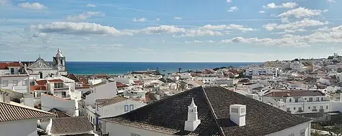
At first the coast is flat and bright: salt pans, lagoons, flamingos in the mud of the Ria Formosa, whitewashed houses with chimneys like lace crochet. Beyond Lagos the land rises up – ochre limestone cliffs, grottoes, arches – and at Cabo de São Vicente Europe ends at a sixty-metre wall against which the Atlantic rolls in unchecked. After that it turns quiet and rugged. The Costa Vicentina is a narrow strip of schist, rockrose and heath, the wind smells of salt and eucalyptus, and on the cliffs of Cabo Sardão white storks nest above the surf. From the sliding door you see surfers in the bays of Amado and Arrifana, fishing boats in the estuary of the Mira and, at the end, rice fields near Comporta with herons standing in them. This route rewards those who find a rhythm: hike in the morning, drive at midday, spend the evening on a legal pitch – because almost the entire west coast is a nature park.
Stage-by-stage plan
1Stage 1: Tavira to Faro via Fuseta and Olhão (approx. 40 km)
- The drive
- From Tavira head west on the N125, with short detours down to the lagoon at Fuseta and into the fishing town of Olhão, then on to Faro. The N125 is wide but busy, with many roundabouts, traffic lights and industrial estates; the parallel A22 (Via do Infante) is quicker but has no views. Around an hour without stops.
- Highlights & must-sees
- Tavira: the arched bridge over the Gilão, the castle ruins with views over the rooftops and church towers, and the Quatro Águas jetty for the crossing to Ilha de Tavira; to the west at Pedras d’El Rei a little train runs through the lagoon to Praia do Barril with its anchor cemetery (Cemitério das Âncoras).
- Olhão: the two market halls on the waterfront, with an additional farmers’ and fish market in front of them on Saturdays; boats leave from here for the islands of Armona and Culatra in the Ria Formosa.
- Faro: the old town (Cidade Velha) behind the Arco da Vila with its cathedral and stork nests on towers and roofs, plus the bone chapel of the Igreja do Carmo.
- CampingSpirit overnight tip
-
Official campsite or RV park: Near Tavira: Camping Ria Formosa in Cabanas de Tavira (electricity, sanitary facilities, water and waste disposal, pool; Kampaoh now runs a glamping site on the grounds – check in advance whether and when pitches are available for motorhomes) or the private CP Algarve Motorhome Park Tavira with water and waste disposal on the edge of town. In Olhão the Parque de Campismo do Sindicato dos Bancários do Sul e Ilhas, a large site with pine trees and water and waste disposal; in Faro the private Faro Campervan Park on the western edge of town. The campsite on Ilha de Tavira can only be reached by tent campers without a vehicle.
Free camping or nature tip (where legal): The entire lagoon, including its islands, dunes and salt pans, belongs to the Parque Natural da Ria Formosa and the Natura 2000 network. The strict version of Art. 50.º-A Código da Estrada applies here: overnighting in a motorhome (pernoita) outside expressly authorised sites is prohibited, and the fine is 120 to 600 euros. The beach car parks on the lagoon and at the harbour in Olhão are checked regularly by the GNR and Polícia Marítima.
- Insider tip for campers
- If you are coming from Spain, fill up in Ayamonte or Huelva before the border – diesel is usually considerably cheaper in Spain. The A22 has been toll-free since January 2025. The old towns of Tavira, Olhão and Faro are narrow and riddled with cobbles and one-way streets: park in the waterfront car parks outside and walk.
2Stage 2: Faro to Lagos via Carvoeiro and Praia da Marinha (approx. 95 km)
- The drive
- Take the A22 or the N125 west to Lagoa, then minor roads down to the rocky Algarve coast between Carvoeiro, Benagil and Praia da Marinha, and on via Portimão (bridge over the Arade) and Alvor to Lagos. The spur roads to the beaches are narrow, steep and parked up in summer; with stops a full day, pure driving time around 1.5 hours.
- Highlights & must-sees
- Percurso dos Sete Vales Suspensos: a cliff path of just under six kilometres (one way) between Praia de Vale Centeanes and Praia da Marinha, with views of rock arches, grottoes and the sinkhole above the Benagil cave.
- Algar Seco near Carvoeiro: eroded limestone rocks with steps, pools and natural windows above the sea.
- Benagil cave (Algar de Benagil): visible only from the water; since August 2024 landing on the cave beach and swimming in have been prohibited, kayaks may only enter on guided tours, and boats are subject to maximum numbers and limited stays – check the current rules locally.
- CampingSpirit overnight tip
-
Official campsite or RV park: In Lagos: Parque de Campismo da Trindade, a small site within walking distance of the old town and Ponta da Piedade; Turiscampo and Orbitur Valverde lie near Luz west of town, both with electricity, sanitary facilities, pool and water and waste disposal. Halfway: Parque de Campismo de Armação de Pêra and several private motorhome parks near Albufeira, such as the Algarve Motorhome Park Falésia.
Free camping or nature tip (where legal): The rocky Algarve coast lies within zones of the coastal management plans (POOC/POC) and partly in Natura 2000 areas: overnighting on cliff-top and beach car parks is prohibited here too. Many municipalities have also fitted beach car parks with height barriers or “proibido autocaravanas” signs. The numerous private motorhome parks and municipal Áreas de Serviço are the legal alternative.
- Insider tip for campers
- The car parks above Praia da Marinha and Benagil are full from late morning – arrive early or walk the trail from Vale Centeanes. Do not drive into the old town of Lagos in a motorhome; on Saturday mornings the farmers’ market (Mercado do Levante) by the bus station is worth a visit.
3Stage 3: Lagos to Sagres via Burgau and Salema (approx. 35 km)
- The drive
- In the morning walk to Ponta da Piedade, then head west on the N125 with detours into the fishing villages of Luz, Burgau and Salema (narrow, steep access roads), continuing via Vila do Bispo and on the N268 across the plateau to Sagres. Then the spur out to Cabo de São Vicente (around 6 km each way). A good hour’s driving.
- Highlights & must-sees
- Ponta da Piedade: rock stacks and grottoes of golden limestone, steps down to the water, at its most beautiful in the morning backlight.
- Fortaleza de Sagres: a fortress on a headland with the large stone wind rose and a circular path above the cliffs.
- Cabo de São Vicente: lighthouse on the south-western tip of mainland Europe, with a small lighthouse museum; in autumn birds of prey migrate through here.
- CampingSpirit overnight tip
-
Official campsite or RV park: Parque de Campismo de Sagres (Orbitur) in the pine forest north of the village, with electricity, sanitary facilities and water and waste disposal; check opening times. Near Salema the Salema Eco Camp, near Figueira the private Figueira Caravan Park with electricity and water and waste disposal.
Free camping or nature tip (where legal): The municipality of Vila do Bispo lies almost entirely within the Parque Natural do Sudoeste Alentejano e Costa Vicentina. Pernoita at the cape, at the Fortaleza and at the beaches of Beliche, Tonel or Martinhal is prohibited and enforced: in 2024 the GNR opened 346 fine proceedings in eleven enforcement operations in the municipality. In 2025 the municipality also announced a by-law intended to prohibit overnighting within built-up areas outside authorised sites as well, and plans to increase the number of Áreas de Serviço – check the current status.
- Insider tip for campers
- At sunset the access road to Cabo de São Vicente is jammed, the car park full and turning large vehicles difficult. Go early in the morning, or leave the camper on the site and take the bike. There are supermarkets in Sagres and Vila do Bispo; the nearest cheap petrol stations are more likely to be on the N125 towards Lagos.
4Stage 4: Sagres to Aljezur via Carrapateira and Arrifana (approx. 50 km)
- The drive
- Via Vila do Bispo, head north on the N268 through heath and eucalyptus. At Carrapateira a narrow, partly unsurfaced panoramic road leads around the Pontal da Carrapateira to the beaches of Bordeira and Amado – only in dry conditions and with a compact vehicle. Before Aljezur, the detour to the cliffs of Arrifana. Winding but well built; around 1.5 hours.
- Highlights & must-sees
- Pontal da Carrapateira: a circular cliff walk with views over the dunes of Praia da Bordeira and the surf bay of Amado; in the village, the small Museu do Mar e da Terra.
- Arrifana: a semicircular bay beneath high schist cliffs; up on Ponta da Atalaia, the foundations of the Ribat, a 12th-century Islamic fortified monastery.
- Aljezur: castle ruins above the valley of the Ribeira de Aljezur, with the old quarter and its market hall by the river below.
- CampingSpirit overnight tip
-
Official campsite or RV park: Parque de Campismo do Serrão north of Aljezur, with electricity, sanitary facilities, pool and water and waste disposal; check season and advance booking. Further campsites lie in the hinterland between Aljezur and Rogil.
Free camping or nature tip (where legal): The entire coast between Sagres and Odeceixe belongs to the nature park. Beach car parks at Bordeira, Amado, Arrifana and Monte Clérigo are for day visitors; pernoita is prohibited there, as is parking with an extended awning, chairs or table. Driving on sand tracks and paths off the public roads is prohibited in the nature park in any case. The GNR, Polícia Marítima and ICNF carry out checks, especially in the high season and at Easter.
- Insider tip for campers
- The road down to Arrifana is steep and the car park at the end is cramped – large vehicles park up at the edge of the village. The Rota Vicentina (Trilho dos Pescadores) runs along the cliffs here: wear sturdy footwear, as walking in sand is tiring. Do not drive the cliff tracks in strong winds.
5Stage 5: Aljezur to Zambujeira do Mar via Odeceixe (approx. 45 km)
- The drive
- Head north on the N120 via Rogil to Odeceixe; the bridge over the Ribeira de Seixe marks the border between the Algarve and the Alentejo. Continue on the N120 to São Teotónio and take minor roads out to the coast at Zambujeira do Mar. The plateau between Odeceixe and Zambujeira is dominated by greenhouses and polytunnels; wide, easily driven roads, around an hour.
- Highlights & must-sees
- Praia de Odeceixe: a beach at the looping mouth of the Ribeira de Seixe, with river and sea water side by side; view from the path above the beach car park.
- The windmill of Odeceixe on the hill above the village.
- Zambujeira do Mar: a white church on the cliff above the beach, and a cliff path south to the fishing harbour of Entrada da Barca.
- CampingSpirit overnight tip
-
Official campsite or RV park: Parque de Campismo São Miguel near Odeceixe in the pine forest, with electricity, sanitary facilities and pool; Parque de Campismo Zambujeira on the edge of Zambujeira, with electricity, sanitary facilities and water and waste disposal. Further small sites lie in the hinterland of São Teotónio.
Free camping or nature tip (where legal): Odeceixe, Zambujeira and the coast of Odemira lie within the nature park; beach car parks are off-limits at night, and parking for motorhomes is restricted on the road to Praia de Odeceixe. The allowance of 48 hours of pernoita per municipality applies only outside protected areas – which on this coast means practically nowhere.
- Insider tip for campers
- In early August the MEO Sudoeste music festival takes place near Zambujeira: roads, pitches and campsites in the area are then full for days – avoid the festival weekend. The small centre of Odeceixe has very narrow lanes; park down on the N120.
6Stage 6: Zambujeira do Mar to Vila Nova de Milfontes via Cabo Sardão (approx. 40 km)
- The drive
- Take minor roads north to Cavaleiro and out to Cabo Sardão, then via Almograve to Vila Nova de Milfontes, which you reach over the bridge across the Rio Mira. Rural, narrow roads with field gates, farm traffic and hardly any passing places, but few gradients. Around an hour.
- Highlights & must-sees
- Cabo Sardão: lighthouse on the cliff; on the rock stacks in front of it white storks nest directly above the sea – an exception worldwide, best in spring.
- Almograve: dune coast and rock platforms that invite you to walk at low tide; part of the Trilho dos Pescadores.
- Vila Nova de Milfontes: the mouth of the Mira with the Forte de São Clemente, Praia das Furnas on the south side and kayak trips upriver.
- CampingSpirit overnight tip
-
Official campsite or RV park: In Vila Nova de Milfontes: Camping Milfontes and Camping Campiférias in town, plus Orbitur Sitava to the north between Milfontes and Porto Covo, all with electricity and sanitary facilities; check water and waste disposal and pitch sizes in advance.
Free camping or nature tip (where legal): The same applies here: nature park, Natura 2000 and coastal management plan. The farm tracks along the cliffs are private grazing and forestry tracks, and the car parks at Cabo Sardão, Almograve and Furnas are for day visits only. The bridge over the Mira and the riverside road in Milfontes are very busy in summer – anyone parking here overnight will be approached.
- Insider tip for campers
- Come to Cabo Sardão in the afternoon, when the sun falls on the stork nests from the west, and keep your distance from the cliff edge – the schist breaks away. In Milfontes a paddle on the Mira on the rising tide is worthwhile; kayaks are rented out on the riverside promenade.
7Stage 7: Vila Nova de Milfontes to Lagoa de Santo André via Porto Covo and Sines (approx. 55 km)
- The drive
- Take the coast road north to Porto Covo, stopping at the bay opposite Ilha do Pessegueiro. Then via the N120 or IC4 past Sines – harbour, refinery and industry dominate the scene – and via Santo André to the lagoon. Flat, wide roads, narrow only in the centre of Porto Covo; around an hour.
- Highlights & must-sees
- Ilha do Pessegueiro: a small island with fortress ruins off the coast, with a second fort opposite on land; a hiking trail from Porto Covo along bays and rock arches.
- Porto Covo: a white village square with low houses in blue and white, and the small harbour cove below.
- Reserva Natural das Lagoas de Santo André e da Sancha: a coastal lagoon with herons, spoonbills and migratory birds, boardwalks and observation points.
- CampingSpirit overnight tip
-
Official campsite or RV park: In Porto Covo: Camping Porto Covo on the edge of the village, with electricity, sanitary facilities and water and waste disposal; near Ilha do Pessegueiro, the campsite of the same name. At Lagoa de Santo André: Parque de Campismo de Santo André with a service point, plus the private Alentejo Litoral Caravan Park near Vila Nova de Santo André.
Free camping or nature tip (where legal): Porto Covo and the coast as far as Sines are still within the nature park; Lagoa de Santo André is a nature reserve. In both cases pernoita outside authorised sites is prohibited (120 to 600 euros). The municipality of Sines does not permit overnighting around the harbour and industrial zones; outside protected areas municipal rules apply – watch for signs.
- Insider tip for campers
- Sines is the best place on this stage for a big shop and to fill up: supermarkets and petrol stations are on the bypass. The Castelo de Sines in the small old town, birthplace of Vasco da Gama, can be reached on foot from the car park by the bay.
8Stage 8: Lagoa de Santo André to Setúbal via Comporta and the ferry from Tróia (approx. 75 km)
- The drive
- Head north on the N261 through pine and cork oak forest via Melides and Carvalhal to Comporta, then along the narrow Tróia peninsula to the car ferry terminal and across the mouth of the Sado to Setúbal with Atlantic Ferries. Straight, flat roads, with heavy traffic towards the beaches on summer weekends. Around 1.5 hours plus waiting time and crossing.
- Highlights & must-sees
- Cais Palafítico da Carrasqueira: a fishermen’s jetty on wooden stilts in the mud of the Sado estuary, a photo subject at low tide and with the sun low.
- Rice fields of Comporta: storks and herons in the fields, plus the beaches of Comporta and Carvalhal behind the dunes.
- Ruínas Romanas de Tróia: Roman fish-salting works on the shore of the lagoon; with luck you will see the Sado’s bottlenose dolphins during the crossing.
- CampingSpirit overnight tip
-
Official campsite or RV park: Área de Serviço para Autocaravanas do Carvalhal (municipality of Grândola): five pitches with electricity, water, and grey water and cassette disposal; arrive early. In Setúbal, the Ecoparque do Outão at the foot of the Serra da Arrábida, right on the coast road west of the city.
Free camping or nature tip (where legal): The Tróia peninsula, the dunes of Comporta and the Sado estuary belong to the Natura 2000 network or the Reserva Natural do Estuário do Sado: overnighting outside authorised sites is prohibited. The municipality of Grândola expressly designates a legal site in the Área do Carvalhal. In the Arrábida nature park near Setúbal, beach access is restricted in summer, and parking on the coast road is checked.
- Insider tip for campers
- The car ferry does not leave from the catamaran jetty at the marina; follow the “Ferry” signs. The vehicle fare depends on vehicle category or length; fares and timetable at atlanticferries.pt. On summer weekend afternoons long queues form towards Setúbal – cross in the morning. In Setúbal, the Mercado do Livramento is worth a visit in the morning, and fried cuttlefish (choco frito) in the evening.
Camping practice & local rules
Wild camping & overnight parking
- The legal basis is Art. 50.º-A of the Código da Estrada, introduced at the end of 2020 and revised by Lei n.º 66/2021 of 24 August 2021. It distinguishes three things: parking (estacionamento) is permitted for motorhomes wherever parking is permitted for their vehicle class. Pernoita is staying in the motorhome with occupants between 10 pm and 7 am. Aparcamento means parking in a way that takes up more space than the parking bay – awning, chairs, tables, opened windows and the like.
- Outside protected areas, pernoita is permitted for up to 48 hours in the same municipality unless the municipality rules otherwise; on sites expressly authorised for it there is no time limit. Violations cost 60 to 300 euros. Camping in public spaces, discharging waste water or rubbish outside the facilities provided for this purpose and occupying space beyond the vehicle cost an additional 30 to 150 euros.
- In areas of the Natura 2000 network, in protected areas (áreas protegidas) and in the zones of the coastal management plans (POOC), pernoita and aparcamento outside expressly authorised sites are prohibited, with fines of 120 to 600 euros; parking motorhomes outside authorised areas can also be fined 60 to 300 euros there. On this route that affects almost the whole way: the Parque Natural da Ria Formosa, the Parque Natural do Sudoeste Alentejano e Costa Vicentina (from Burgau to south of Sines), the Lagoa de Santo André, the Sado estuary and Tróia.
- Enforcement is carried out by the GNR, Polícia Marítima, ICNF and municipal police; in the Sudoeste Alentejano e Costa Vicentina nature park, in coordinated operations with hundreds of fine proceedings a year. If you pay on the spot, the minimum amount usually applies. Wild camping with a tent is not permitted in Portugal outside licensed sites in any case.
- You can stay legally on campsites (parques de campismo), municipal and private Áreas de Serviço para Autocaravanas (ASA) and the numerous private motorhome parks of the Algarve. Apps: park4night, Campercontact; the tourism boards Visit Algarve and Visit Alentejo list the official Áreas. Reviews in apps praising a beach car park as “quiet” do not change the legal position.
Waste disposal & supplies
- Water and waste facilities are plentiful in the Algarve: almost every motorhome park and many municipalities offer an ASA with water and grey water and cassette disposal, sometimes operated with coins or a card or for a fee on site. On the Costa Vicentina the network is thinner – fill up and empty everything before Aljezur and before Vila Nova de Milfontes.
- Empty grey water and toilet cassettes only at service points; discharging in car parks or into drains is prosecuted rigorously on this coast.
- Tap water in Portugal is drinkable. The Algarve and the Alentejo suffer from recurring drought and water-saving measures: do not use your tank for showering on the pitch or washing the vehicle, and do not fill containers at public fountains where this is prohibited.
- Gas: German exchange cylinders are not refilled; Portuguese cylinders (Galp, Repsol, Rubis) with a deposit have different connections. Autogas (GPL Auto) is available at many Galp, Repsol and Cepsa petrol stations, including along the A22 and on the N125; for refillable cylinders bring a complete adapter set (Dish, bayonet, ACME). GPL pumps are rare on the west coast – fill up before Sagres.
Vehicle size & traffic rules
- Speed limits: motorhomes up to 3.5 t are treated like cars – 50 km/h in built-up areas, 90 km/h on country roads, 100 km/h on expressways, 120 km/h on motorways. Motorhomes over 3.5 t count as heavy vehicles with lower limits (usually 80 km/h on country roads and 90 to 100 km/h on motorways, depending on classification). Vehicles with trailers: 70 km/h on country roads, 80 km/h on expressways, 100 km/h on motorways. The minimum speed on motorways is 50 km/h.
- Tolls: the A22 (Via do Infante) along the Algarve has been toll-free since 1 January 2025. If you drive on the A2 from or towards Lisbon, you pay at toll booths; motorhomes with two axles and a height of 1.10 m or more above the front axle usually go in class 2. For electronically collected tolls on other routes, there are solutions for foreign number plates such as EASYToll or a Via Verde device.
- There are no low-emission zones on this route; Lisbon has a Zona de Emissões Reduzidas (ZER) with two zones and emission-standard requirements on weekdays, which this route does not touch.
- Alcohol limit 0.5 per mille, 0.2 per mille for drivers who have held a licence for less than three years and for professional drivers. Mobile phones at the wheel only hands-free. Carry a high-visibility vest and warning triangle; overhanging loads such as bike racks must be secured, and number plates and lights must be visible.
- Wildfires: during the critical period set each year (usually July to September, longer in dry conditions), fires, barbecues and setting off fireworks are prohibited in rural areas; the Portuguese meteorological institute IPMA publishes the danger levels daily.
- Swimming: the west coast has powerful surf and currents, and many beaches are lifeguarded only in summer. Observe the flags – green swimming permitted, yellow caution with no swimming, red swimming prohibited – and do not step too close to the edge on the cliffs.
CampingSpirit packing & preparation checklist
- A complete GPL adapter set and a refillable cylinder: German exchange cylinders are not refilled in Portugal, and there is hardly any autogas on the Costa Vicentina.
- Good hiking boots and gaiters for the Trilho dos Pescadores of the Rota Vicentina – the cliff paths are sandy and exposed in places.
- Binoculars for the cliff storks at Cabo Sardão, the flamingos of the Ria Formosa and the dolphins in the Sado estuary.
- Windproof clothing and a warm layer: even in summer a strong, cool north wind blows on the west coast in the evening.
- Sand ladders or traction aids for soft ground on sandy campsites among pines and dunes.
- A bike or e-bike: it gets you to the cape of São Vicente, old towns and beach access roads with height restrictions without parking or turning problems.
As of 2026-09. Closures, fees and booking rules change: check official sources before you go.