Rhine Gorge, Viamala and San Bernardino to Bellinzona
A turquoise forest lake, the white cliffs of the Rhine Gorge, the Viamala’s narrow chasm and the San Bernardino Pass down to Bellinzona’s castles.
- Distance
- approx. 131 km (81 mi)
- Driving
- 1 h 48 min
- Suggested days
- 3
- Stops
- 9
- Countries
- Switzerland
- Best time to go
- June–August
- Tolls and vignettes
- ≈ €40
- Updated
- July 27, 2026
At a glance: 3-day road trip of about 131 km (81 mi) with 9 stops, from Chur to Bellinzona. About 1 h 48 min of driving in total. Best time to go: June–August. Tolls and vignettes for a car: about €40 (Switzerland, Vignette).
More road trips in Switzerland · More road trips from Feldkirch
Photos along the route


Route description
From Chur drive west on road 19 to Flims, about 20 km. Leave the car at Flims Waldhaus and walk through the forest to the Caumasee, a turquoise lake with a lido. From the same car park a path leads by Conn to the Il Spir platform, which juts out over the Ruinaulta, the Swiss Grand Canyon of the Rhine. The round trip takes about two to three hours.
Return towards Reichenau and head south to Thusis. Just beyond the town, turn off the A13 motorway onto the old road into the Viamala. Here the Hinterrhein runs through a gorge only a few metres wide, and 321 steps lead down to the water. A little further south, the church of St. Martin in Zillis has a painted wooden ceiling from the 12th century.
Continue on the old road through the Rofla Gorge to Splügen, a village of stone houses where the old routes over the Splügen and San Bernardino passes split. Take the San Bernardino pass road, which climbs in hairpins to 2,065 m, while the A13 passes below in a tunnel. The pass road is closed in winter, roughly November to May. The A13 motorway needs a Swiss vignette.
The southern side drops into the Italian-speaking Mesolcina valley past the castle ruin of Mesocco. At Bellinzona, about 55 km from the pass, three castles guard the valley on the route to Italy; Castelgrande, reached by lift from the old town, is the largest. The old roads are fine for motorhomes but narrow in the Rofla. Go between June and early October.
Which stops are on the route from Chur to Bellinzona?
In driving order. Distances are estimates between consecutive stops.
- 1Start
Chur
Switzerland - 223 km
Caumasee
NatureFlims, SwitzerlandA turquoise lake in the forest below Flims, warm enough for swimming in summer. Walk 20 minutes from the Flims Waldhaus car parks; a lift runs down to the lido, which charges entry in season.
- 33 km
Il Spir Rhine Gorge viewpoint
ViewsFlims, SwitzerlandA steel platform on the cliff edge above the Ruinaulta, the white limestone gorge of the Rhine. Walk from Flims Waldhaus via Conn through the forest in about an hour; there is no road access.
- 420 km
Thusis
Switzerland - 55 km
Viamala Gorge
NatureZillis, SwitzerlandA deep, narrow gorge of the Hinterrhein on the old road south of Thusis, explored on 321 steps and bridges. Paid entry, open April to October, with parking by the kiosk at the top.
- 619 km
Splügen
Switzerland - 716 km
San Bernardino Pass
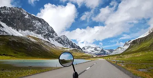
ViewsSan Bernardino, SwitzerlandA 2,065 m pass above the A13 tunnel, with a small lake and rocky knolls at the top and quiet hairpins on both sides. The pass road is closed in winter, the tunnel is open all year.
- 844 km
Castelgrande, Bellinzona
HistoryBellinzona, SwitzerlandThe largest of Bellinzona’s three UNESCO-listed castles, on a rock in the town centre with walls running down into the valley. A lift from Piazza del Sole goes up; the courtyards are free.
- 90 km
Bellinzona
Switzerland
How do you drive the route from Chur to Bellinzona in 3 days?
3 days, split by driving time. Campsites from OpenStreetMap: check opening dates before you go.
- Day 1: Chur → Thusis · 45 km · 0 h 38 minOn the way: Caumasee, Il Spir Rhine Gorge viewpoint.Overnight nearby, for example: Camping Andeer - Sut Baselgia (10 km); Camping Pradafenz (12 km).
- Day 2: Thusis → San Bernardino Pass · 41 km · 0 h 34 minOn the way: Viamala Gorge, Splügen.Overnight nearby, for example: Camping Splügen (12 km); Campodolcino Camping (16 km).
- Day 3: San Bernardino Pass → Bellinzona · 45 km · 0 h 37 minOn the way: Castelgrande, Bellinzona.Overnight nearby, for example: CLM - Camping Lago Maggiore (13 km); Lido Mappo (13 km).
When is the best time for the route from Chur to Bellinzona?
The most pleasant months are usually June–August. Still fine, with some compromises, in May and September. Cold, short days in December–March. July and August are the busiest months: book campsites early.
Estimate from long-term temperature averages, terrain and pass seasons
What should you know before driving the route from Chur to Bellinzona?
Tolls and vignettes for a car: about €40 (Switzerland, Vignette).
- Switzerland: Vignette needed for motorways. Vehicles over 3.5 t pay the heavy vehicle charge instead of the vignette. Motorway limit for cars: 120 km/h.
Road rules and fees change. Check official sources before you travel.
More routes for the best months
Practical guides for this route


Themes
Plan this route for your vehicle
Scout adapts this route to your vehicle, your days and your budget.
FAQs
How long is Rhine Gorge, Viamala and San Bernardino to Bellinzona?
3-day road trip of about 131 km (81 mi) with 9 stops, from Chur to Bellinzona. About 1 h 48 min of driving in total.
How many days do you need for Rhine Gorge, Viamala and San Bernardino to Bellinzona?
We suggest 3 days: about 1 h 48 min of driving, which leaves time for the stops.
Where does Rhine Gorge, Viamala and San Bernardino to Bellinzona start and end?
It starts in Chur and ends in Bellinzona.
Which countries does Rhine Gorge, Viamala and San Bernardino to Bellinzona pass through?
Switzerland.
Where can you camp along Rhine Gorge, Viamala and San Bernardino to Bellinzona?
OpenStreetMap lists 92 campsites and motorhome stopovers within 20 km of the stops on this route. For example: Camping Pradafenz, Camping Trin and Camping Surcuolm.
How much are the tolls on the route from Chur to Bellinzona?
Tolls and vignettes for a car: about €40 (Switzerland, Vignette). Estimate with typical rates; motorhomes pay more, and vehicles over 3.5 t often pay by distance.