 📷 Photo by Jöran Maaswinkel on Unsplash
Route Nationale 7 (Route des Vacances)
National road 7 runs from Paris via Lyon, Avignon and Aix-en-Provence to Menton and was the classic holiday route to the south. Today large stretches carry other numbers.
- Region
- France: Île-de-France to Côte d'Azur
- Length
- About 1,000 km
- Start / end
- Paris – Menton
- Suggested time
- At least 5 days
- Best season
- Spring and September; summer is busy
What should you know before visiting Route Nationale 7 (Route des Vacances)?
Tolls and vignettes for a car: about €30 (France). Mountain passes: Col du Galibier (2,642 m, usually open June–October).
- The A6 and A7 motorways took over long-distance traffic in the 1960s. About half of the old route was later downgraded to departmental roads.
- Signs on the way show new numbers, such as D6007 on the Riviera and DN7 in the Var. Set up navigation and maps by place names, not only by "N7".
- Summer traffic has traditionally been heavy. A travel article recommends spring or September and allows at least five days. There were roadside fires in the Estérel; check conditions beforehand.
The drive
The route starts in Paris at the Porte d'Italie and runs south via Fontainebleau, Nemours, Montargis and Briare. It continues via Nevers, Moulins and Roanne to Lyon, then down the Rhône valley via Vienne, Valence, Montélimar, Orange and Avignon. The Provence leg runs via Aix-en-Provence and Brignoles to the coast with Fréjus, Cannes, Antibes and Nice. It ends at Menton. In total it is about 1,000 km.
Planning
Because stretches became departmental roads, condition and width can differ from one département to the next. No reliable figures on height, length or weight limits for motorhomes along the whole route are given here; follow signs in village centres. For overnight stays, campsites and aires are options; rules for staying elsewhere are set by municipalities. Check locally beforehand.
FAQs
How long is the Route nationale 7?
The full route from Paris to Menton was about 1,000 km long; one reference gives 994 km. Because of renumbering and bypasses, the distance driven today may differ slightly.
Why is it called the Route des Vacances?
For decades it carried holidaymakers from Paris and northern France to the Mediterranean. The rush at holiday time brought heavy traffic. Other nicknames were Route bleue and, sarcastically, Route de la mort.
When is the best time to travel?
A travel article recommends spring or September and advises against high summer because of traffic. The exception is the July festivals in Orange, Avignon and Lyon. Check road reports beforehand.
How much are the tolls on Route Nationale 7 (Route des Vacances)?
Tolls and vignettes for a car: about €30 (France). Estimate with typical rates; motorhomes pay more, and vehicles over 3.5 t often pay by distance.
Places to see

 © Christian David · CC BY-SA 4.0
Aiguille du Midi
A cable car climbs to 3,842 m, face to face with Mont Blanc. Bring warm layers, even in August.

 © Bonzon · CC BY-SA 4.0
Col du Galibier
2,642 m on the Route des Grandes Alpes and a Tour de France classic. Usually open June to October.

 © Andrew Bossi · CC BY-SA 2.5
Lauterbrunnental
A glacial valley with dozens of waterfalls, including Staubbach Falls beside the village.

 Photo by Paul Underwood on Unsplash
Gorges du Verdon
One of Europe’s deepest canyons, with turquoise water below. The Route des Crêtes is narrow, so large…

 Photo by Geertje Caliguire on Unsplash
Kapellbrücke
A covered wooden bridge with painted panels and a stone water tower, crossing the Reuss.

 Photo by Sirawit Chuanart on Unsplash
Furkapass
A 2,429 m pass with hairpins above the Rhône Glacier. Usually open June to October.

 © Raimond Spekking · CC BY-SA 4.0
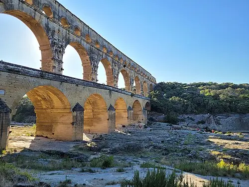
Pont du Gard
A three-tier Roman aqueduct bridge over the Gardon river. You can swim below it in summer.

 © DiskoDieter · CC BY-SA 4.0
Mont Ventoux
The bare limestone summit of Provence at 1,910 m. The top road is closed in winter.
Trip guides

 Photo by Hongbin on Unsplash
Route des Grandes Alpes: Lake Geneva to the Riviera
 Photo by Flora Hon on Unsplash
Swiss Alpine passes from Lucerne

 © JasonDFR · CC BY-SA 4.0
Provence: lavender, gorges and Roman bridges

 Photo by Patrick Pahlke on Unsplash