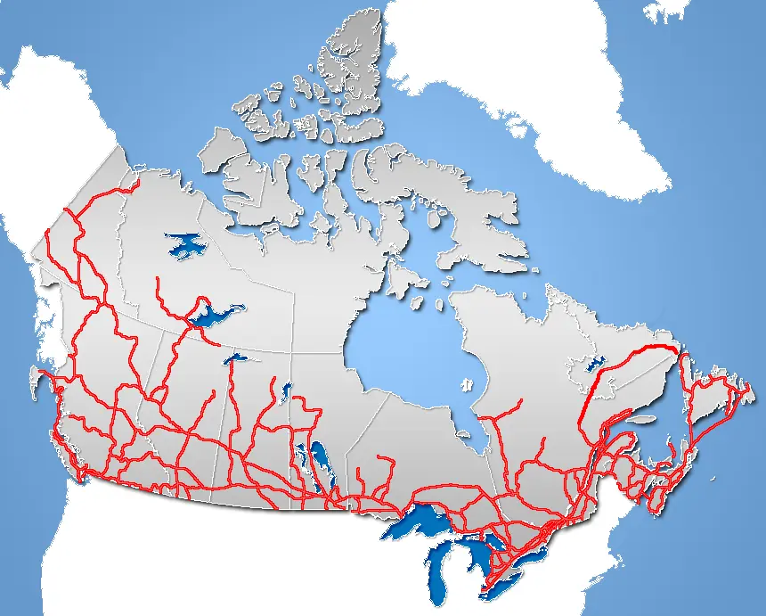

Crowsnest Highway (Hwy 3)
The Crowsnest Highway runs across southern British Columbia near the US border, crosses several passes and ends at Crowsnest Pass on the Alberta line.
- Region
- British Columbia
- Length
- 521 mi (BC section)
- Start / end
- Hope – Crowsnest Pass
- Top elevation
- 5,820 ft (Kootenay Pass)
- Best season
- Summer to early fall
What should you know before visiting Crowsnest Highway (Hwy 3)?
No toll roads expected for a car. Mountain passes: Going-to-the-Sun Road (Logan Pass) (2,026 m, usually open July–September). Size limits for motorhomes: Going-to-the-Sun Road, Glacier NP (MT) (length 20 ft 12 in (6.4 m), height 10 ft 0 in (3.1 m)).
- Kootenay Pass, at about 5,820 ft (1,775 m), is the highest point. It stays open year-round but is often closed in bad weather for avalanche control or clearing.
- Winter tire and chain signs apply from October 1 to April 30, the province says, and on some highways outside mountain passes and heavy-snow areas only until March 31. Check DriveBC for current conditions.
- The road is mostly two-lane and shared with truck traffic. Only about 4 mi (7 km) beyond Hope is freeway, then it is two lanes through Manning Provincial Park.
The drive
Highway 3 branches off the Trans-Canada at Hope. It climbs through Manning Provincial Park over Allison Pass (4,403 ft) and Sunday Summit (4,206 ft) to Princeton, then follows the Similkameen valley via Keremeos to Osoyoos. Next comes Anarchist Summit (4,055 ft) on the way to Greenwood, then Grand Forks, Christina Lake, Castlegar and Salmo, over Kootenay Pass to Creston, then Cranbrook, Fernie and Sparwood up to Crowsnest Pass.
Planning
The road runs close to the US border for long stretches and follows the historic Dewdney Trail for about 80 percent of its length. Including Alberta, the Crowsnest Highway continues to Medicine Hat for a total of 721 mi (1,161 km). At Kootenay Pass, a Gazex system handles avalanche control. Before winter trips, check DriveBC for closures and tire rules.
Camping
At recreation sites run under Recreation Sites and Trails BC, the province limits a stay to 14 consecutive days, and some operators charge fees. Campfires must follow current fire prohibitions. No verified information was found on wild camping outside such sites, on motorhome length limits or on reservations, so ask the campground or operator beforehand.
FAQs
How long is the Crowsnest Highway?
The British Columbia section from Hope to Crowsnest Pass is about 521 mi (840 km), depending on the source between 838 and 841 km. With the Alberta part to Medicine Hat the total is 721 mi (1,161 km).
Is Kootenay Pass open in winter?
Yes, it is one of the highest passes in Canada open year-round. In bad weather it is often closed for avalanche control and clearing. Check DriveBC before driving.
Which passes lie along the way?
Heading east: Allison Pass (4,403 ft), Sunday Summit (4,206 ft), Anarchist Summit (4,055 ft), Kootenay Pass (about 5,820 ft) and finally Crowsnest Pass on the Alberta line.
Places to see
 Photo by Gary Corken on Unsplash
Logan Pass – Going-to-the-Sun Road
The high point of Glacier's cliff-hugging road at 6,646 feet. Vehicle size limits apply, and reservations…
 © Zoe Deal zdeal · CC0
Diablo Lake Overlook
Glacial flour turns this reservoir a bright milky turquoise below the North Cascades peaks.
 © Caleb Riston · CC BY 4.0
Steptoe Butte
A quartzite knob rising above the rolling wheat hills of the Palouse. A narrow road spirals to the top,…
 © Steven Pavlov · CC BY-SA 4.0
Palouse Falls
Washington’s state waterfall drops about 200 feet into a basalt bowl carved by Ice Age floods. The…
 © Mobilus In Mobili · CC BY-SA 2.0
Bowman Lake
A long, quiet lake in Glacier’s North Fork, framed by peaks and reached on a rough dirt road. Not suitable…
 © GlacierNPS · Public domain
Two Medicine Lake
The quieter southeast valley of Glacier National Park, with a tour boat, a campground and the short walk to…
 © Loco Steve · CC BY 3.0
Goat Lick Overlook
A viewpoint on US-2 above a mineral bank where mountain goats come to lick salt, most often in early summer.
 Photo by Ray Graciano on Unsplash
Museum of the Plains Indian
A museum on the Blackfeet Reservation with clothing, beadwork and art of the Northern Plains peoples.
Trip guides
 Photo by Michael Kirsh on Unsplash
Going-to-the-Sun Road, west to east
 Photo by Brewing Cats on Unsplash
North Cascades Highway
 Photo by Kush Dwivedi on Unsplash
The Palouse: wheat hills and a hidden waterfall
 Photo by Bill Stephan on Unsplash