
Connemara National Park
Letterfrack, Ireland
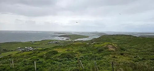
Bog, heath and mountains around the visitor centre at Letterfrack. The Diamond Hill loop is a rewarding climb of two to three hours.
Connemara National Park is in County Galway in the west of Ireland, near Letterfrack on the N59. Across roughly 2,000 hectares it alternates between mountains, bog, heath, grassland and woodland. The park belongs to the Twelve Bens range, whose Benbaun, at 725 metres, is the highest mountain in County Galway. It opened to visitors in 1980.
Four trails are waymarked: the Ellis Wood Nature Trail, the Sruffaunboy Trail, and the Lower and Upper Diamond Trails. From the summit of Diamond Hill the view reaches Tully Mountain, Kylemore Abbey and the Twelve Bens. Check the weather before you climb.
The visitor centre and café open only on certain days of the week (from 1 July 2026 it is closed on Mondays and Tuesdays, as of October 2026), but the park and trails stay accessible. The grounds close during orange and red weather warnings. Dogs must be on a lead, open fires are not allowed, and wild camping is permitted only in remote parts.
- Nearest town
- Letterfrack, Ireland
- Category
- Nature & parks
- GPS
- 53.5500, -9.9460
- Editor's pick
- ★
Hours, fees and access change. Confirm with the operator or park before you go.
Good to know
Best time to go
No month is ideal everywhere on this route; the most pleasant are usually June. Cold, short days in December–February. (Estimate from long-term temperature averages, terrain and pass seasons)
Getting there
- Ireland: Tolls on some roads, bridges or tunnels. Drive on the left. Barrier-free toll on the M50 around Dublin. Motorway limit for cars: 120 km/h.
Featured in these trip guides

Nearby









Campsites nearby
- Renvyle Beach Caravan & Camping ParkMotorhome stopover7 km from Connemara National ParkTentsCaravansMotorhomesToiletsWi-Fi
- Connemara Caravan & Camping ParkCampsite7 km from Connemara National Park
- Clifden Campsite and Caravan ParkCampsite7 km from Connemara National ParkTentsCaravansElectricityDrinking waterShowersToiletsWaste disposalDogs allowed
- Clifden eco Beach Camping & Caravanning ParkCampsite13 km from Connemara National Park · 43 pitchesTentsCaravansMotorhomesElectricityDrinking waterShowersToiletsDogs allowed
- Gurteen Bay Caravan ParkCampsite19 km from Connemara National ParkTentsCaravansShowersToiletsWi-Fi
- Motorhome stopover · ClifdenMotorhome stopover20 km from Connemara National ParkMotorhomes
All campsites in Ireland · Campsite data: © OpenStreetMap contributors, ODbL 1.0 · Updated October 3, 2026
FAQs
Where is Connemara National Park?
Connemara National Park is in Letterfrack, Ireland, at GPS 53.5500, -9.9460. It is about 8 km from Clifden.
Can you camp near Connemara National Park?
Yes. The nearest campsite listed in OpenStreetMap is Renvyle Beach Caravan & Camping Park, about 7 km away; within 25 km there are 6 campsites and motorhome stopovers.
Which road trips pass Connemara National Park?
Connemara National Park is a stop on these CampingSpirit trip guides: Connemara: bogs, the Sky Road and Kylemore.
What is there to see near Connemara National Park?
Places worth a stop nearby: Kylemore Abbey (4 km), Sky Road (12 km), Doo Lough Valley (17 km) and Croagh Patrick (32 km).
When is the best time to visit Connemara National Park?
No month is ideal everywhere on this route; the most pleasant are usually June. Cold, short days in December–February. (Estimate from long-term temperature averages, terrain and pass seasons)