
Peña de Francia
El Cabaco, Spain
A 1,723 m summit with a Dominican sanctuary and wide views over Salamanca and Extremadura. The final road is steep and single-track with passing places; not for large motorhomes.
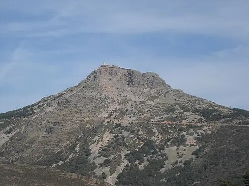
The Peña de Francia, at roughly 1,720 m, is one of the highest summits of the Sierra de Francia south of Salamanca; sources give 1,723 or 1,727 m. The summit belongs to the municipality of El Cabaco. It is famous for the Dominican sanctuary with its Black Madonna. According to tradition, a man named Simón Vila found an image of the Virgin in a grotto in 1434, and the monastery was built in the early fifteenth century. In winter the mountain is practically inaccessible because of snow; most pilgrims come in summer.
From the summit the view stretches over the Campo Charro plain to the north, the Sierra de Tamames to the east and the Gabriel y Galán reservoir to the south. The access road from the road near El Cabaco is about 12 km long, steep and winding, and gains more than 700 m in height; its suitability for large motorhomes is not documented, so enquire beforehand. Walkers can set out from La Alberca, a route of about 8.7 km with 667 m of ascent.
- Nearest town
- El Cabaco, Spain
- Category
- Scenic viewpoints
- GPS
- 40.5147, -6.1682
Hours, fees and access change. Confirm with the operator or park before you go.
Good to know
Best time to go
The most pleasant months are usually May–September. Still fine, with some compromises, in April and October. (Estimate from long-term temperature averages, terrain and pass seasons)
Getting there
- Spain: Tolls on some roads, bridges or tunnels. Many former toll motorways are now free; some AP roads still charge. Motorway limit for cars: 120 km/h.
Sources
Featured in these trip guides

Nearby









Campsites nearby
- Camping Las CavenesCampsite7 km from Peña de FranciaTentsCaravansElectricityShowersToilets
- Camping RiomaloCampsite14 km from Peña de FranciaTentsCaravansElectricityDrinking waterWaste disposal
- El Burro BlancoCampsite15 km from Peña de FranciaTentsCaravans
- Camping Vega de FranciaMotorhome stopover16 km from Peña de FranciaTentsMotorhomesElectricity
- Area Autocaravanas "Pico Cervero"Motorhome stopover17 km from Peña de Francia · 17 pitchesCaravansMotorhomesWaste disposalWi-FiFree
- Camping “La Dehesa”Campsite25 km from Peña de FranciaTentsCaravansElectricityShowersToilets
All campsites in Spain · Campsite data: © OpenStreetMap contributors, ODbL 1.0 · Updated October 3, 2026
FAQs
Where is Peña de Francia?
Peña de Francia is in El Cabaco, Spain, at GPS 40.5147, -6.1682. It is about 6 km from Ladrillar.
Can you camp near Peña de Francia?
Yes. The nearest campsite listed in OpenStreetMap is Camping Sierra de Francia, about 3 km away; within 25 km there are 13 campsites and motorhome stopovers.
Which road trips pass Peña de Francia?
Peña de Francia is a stop on these CampingSpirit trip guides: Sierra de Francia, Las Hurdes and the Jerte valley.
What is there to see near Peña de Francia?
Places worth a stop nearby: Meandro del Melero (16 km), Granadilla (28 km), Garganta de los Infiernos (48 km) and Plaza Mayor de Salamanca (66 km).
When is the best time to visit Peña de Francia?
The most pleasant months are usually May–September. Still fine, with some compromises, in April and October. (Estimate from long-term temperature averages, terrain and pass seasons)