
Pointe de la Parata and Îles Sanguinaires
Ajaccio, France
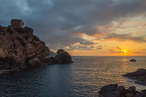
A headland with a Genoese tower facing a line of red granite islets, 12 km from Ajaccio on the D111. The path round the point takes 45 minutes; come at sunset and use the paid car park.
The Pointe de la Parata lies a good 12 km from Ajaccio, at the end of the D111 coastal road. A 16th-century Genoese tower stands on the headland, facing the Sanguinaires archipelago of four islands, the largest of which is Mezu Mare. The lighthouse there came into service in the mid-19th century (1844, or 1845 according to another source), was automated in the 1980s and inspired Alphonse Daudet to write one of his "Lettres de mon moulin". You can reach Mezu Mare only by boat; trips leave from Ajaccio and Porticcio. The lighthouse itself is not open to visitors. The area has held the “Grand Site de France” label since 2017, and the islands’ name recalls the reddish tint of the rock. Boat trips from the Tino-Rossi port take about three hours, including roughly one hour ashore.
The walk to the tip and back takes about 20 minutes, according to a travel report. The evening is the most atmospheric time, and some boat trips are timed for sunset. Parking may be charged; if you arrive after 9 a.m., it is better to stay in the large lower car park, as the upper one is usually full by then (as of October 2026). From April to October an electric shuttle runs to the tip for visitors with reduced mobility (as of October 2026).
- Nearest town
- Ajaccio, France
- Category
- Scenic viewpoints
- GPS
- 41.9075, 8.6150
- Editor's pick
- ★
Hours, fees and access change. Confirm with the operator or park before you go.
Good to know
Best time to go
The most pleasant months are usually April–June and September–October. Still fine, with some compromises, in March, July–August and November–December. (Estimate from long-term temperature averages, terrain and pass seasons)
Getting there
- France: Motorway tolls. Tolls on most autoroutes; the limit drops to 110 km/h in rain. Motorway limit for cars: 130 km/h.
Sources
Featured in these trip guides


Nearby








Campsites nearby
- Camping BarbicajaCampsite6 km from Pointe de la Parata and Îles SanguinairesTentsCaravansElectricityDrinking waterShowersToiletsWaste disposal
- Les MimosasCampsite10 km from Pointe de la Parata and Îles SanguinairesWi-Fi
- Camping EuropeCampsite16 km from Pointe de la Parata and Îles Sanguinaires
- Le SudCampsite17 km from Pointe de la Parata and Îles Sanguinaires
- BenistaCampsite17 km from Pointe de la Parata and Îles SanguinairesTentsCaravans
- U PrunelliCampsite17 km from Pointe de la Parata and Îles SanguinairesTentsCaravansShowersToilets
All campsites in France · Campsite data: © OpenStreetMap contributors, ODbL 1.0 · Updated October 3, 2026
FAQs
Where is Pointe de la Parata and Îles Sanguinaires?
Pointe de la Parata and Îles Sanguinaires is in Ajaccio, France, at GPS 41.9075, 8.6150. It is about 35 km from Propriano.
Can you camp near Pointe de la Parata and Îles Sanguinaires?
Yes. The nearest campsite listed in OpenStreetMap is Camping Barbicaja, about 6 km away; within 25 km there are 12 campsites and motorhome stopovers.
Which road trips pass Pointe de la Parata and Îles Sanguinaires?
Pointe de la Parata and Îles Sanguinaires is a stop on these CampingSpirit trip guides: Corsica’s mountain heart: Ajaccio to Porto.
What is there to see near Pointe de la Parata and Îles Sanguinaires?
Places worth a stop nearby: Filitosa (28 km), Calanques de Piana (37 km), Porto and Scandola coast (41 km) and Gorges de Spelunca (41 km).
When is the best time to visit Pointe de la Parata and Îles Sanguinaires?
The most pleasant months are usually April–June and September–October. Still fine, with some compromises, in March, July–August and November–December. (Estimate from long-term temperature averages, terrain and pass seasons)