
Pont Valentré
Cahors, France
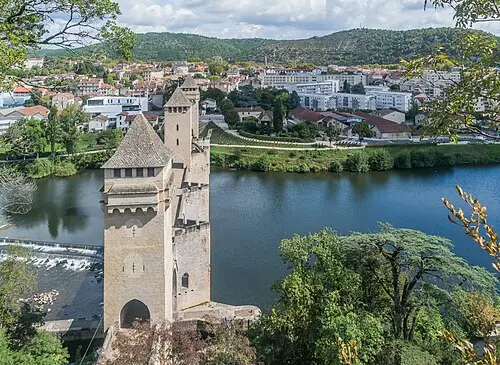
A 14th-century fortified bridge with three towers over the Lot, the symbol of Cahors. Walk across and along the riverside path for the best views.
The Pont Valentré in Cahors was built between 1308 and 1378; the decision to build was taken in 1306, and the bridge opened in 1350. It is 138 m long, with six Gothic arches and three square towers, each about 40 m high (the western one has not survived). Paul Gout restored the bridge between 1867 and 1879, and since 1998 it has been part of the UNESCO World Heritage Site of the Routes of Santiago de Compostela in France.
According to legend, the master builder made a pact with the Devil, who loosens the last stone of the Devil’s Tower at night; the little imp figure that Gout placed in the central tower in 1879 is said to confuse him. Walk across the bridge and along the bank of the Lot. About an hour is enough for the bridge and the riverside path. Crossing is free, but the towers are not open to visitors. Guidebooks call it the best-preserved medieval fortified bridge in France and one of the country’s most photographed monuments. In summer there are paid evening guided tours (booking through the tourist office); the former Cabazat pumping station houses the Maison de l’eau, with information on the bridge (as of October 2026).
- Nearest town
- Cahors, France
- Category
- History & culture
- GPS
- 44.4447, 1.4304
- Editor's pick
- ★
Hours, fees and access change. Confirm with the operator or park before you go.
Good to know
Best time to go
The most pleasant months are usually May–June and September–October. Still fine, with some compromises, in April, July–August and November. (Estimate from long-term temperature averages, terrain and pass seasons)
Getting there
- France: Motorway tolls. Tolls on most autoroutes; the limit drops to 110 km/h in rain. Motorway limit for cars: 130 km/h.
Sources
Featured in these trip guides

Nearby









Campsites nearby
- Camping LamagdelaineMotorhome stopover5 km from Pont Valentré · 29 pitchesTentsMotorhomesElectricityDrinking waterShowersToiletsWaste disposalDogs allowedWi-Fi
- Camping la ChêneraieCampsite10 km from Pont ValentréTentsCaravansElectricityDrinking waterShowersToiletsWaste disposalWi-Fi
- Camping-car Park AlbasMotorhome stopover16 km from Pont ValentréMotorhomesElectricityDrinking waterWaste disposalDogs allowedWi-Fi
- Camping de Castelnau-MontratierCampsite20 km from Pont Valentré · 26 pitchesTentsCaravansElectricityDrinking waterShowersToiletsWaste disposalDogs allowedWi-Fi
- Aire de camping-car des Berges du LotMotorhome stopover20 km from Pont Valentré · 21 pitchesMotorhomesElectricityDrinking waterShowersToiletsWaste disposal
- Aire Montcuq en Quercy BlancMotorhome stopover22 km from Pont Valentré · 22 pitchesMotorhomesElectricityDrinking waterShowersToiletsWaste disposalDogs allowedWi-Fi
All campsites in France · Campsite data: © OpenStreetMap contributors, ODbL 1.0 · Updated October 3, 2026
FAQs
Where is Pont Valentré?
Pont Valentré is in Cahors, France, at GPS 44.4447, 1.4304. It is about 19 km from Saint-Cirq-Lapopie.
Can you camp near Pont Valentré?
Yes. The nearest campsite listed in OpenStreetMap is Saint-Georges, about 1 km away; within 25 km there are 50 campsites and motorhome stopovers.
Which road trips pass Pont Valentré?
Pont Valentré is a stop on these CampingSpirit trip guides: Lot valley and the Gouffre de Padirac.
What is there to see near Pont Valentré?
Places worth a stop nearby: Pech Merle cave (18 km), Saint-Cirq-Lapopie (20 km), Rocamadour (42 km) and Domme (43 km).
When is the best time to visit Pont Valentré?
The most pleasant months are usually May–June and September–October. Still fine, with some compromises, in April, July–August and November. (Estimate from long-term temperature averages, terrain and pass seasons)