
Col de Vars
Vars, France
A 2,108 m pass on the D902 between the Queyras and the Ubaye, with a small lake and pastures on top. It is usually open all year, but carry chains in winter.
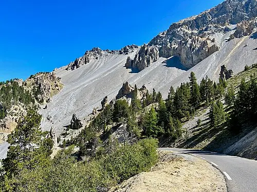
The Col de Vars stands at 2,108 m on the border between the Hautes-Alpes and Alpes-de-Haute-Provence departments, linking the Ubaye valley with the Queyras and the Embrunais. The north side shows green mountain pastures, while the south side is rockier. The road was built in 1893 and is part of the Route des Grandes Alpes. Since 1922 the pass has featured in the Tour de France more than 30 times. The Refuge Napoléon stands on the Hautes-Alpes side and the chapel of Sainte-Marie-Madeleine on the Ubaye side.
From Guillestre it is over 19 km with 1,111 m of ascent, an average gradient of 5.7% and a maximum of 8.7%. In summer, walks start from here to summits and lakes such as the Lac de Lalatcha. According to the tourism portal the pass is open all year, except during heavy snowfall in winter (as of October 2026); carry snow chains then. Allow about an hour for the drive and a viewpoint stop.
- Nearest town
- Vars, France
- Category
- Scenic viewpoints
- GPS
- 44.5390, 6.7030
Hours, fees and access change. Confirm with the operator or park before you go.
Good to know
Best time to go
The most pleasant months are usually May–September. Still fine, with some compromises, in October. Cold, short days in January–February. (Estimate from long-term temperature averages, terrain and pass seasons)
Getting there
- France: Motorway tolls. Tolls on most autoroutes; the limit drops to 110 km/h in rain. Motorway limit for cars: 130 km/h.
Sources
Featured in these trip guides

Nearby









Campsites nearby
- Camping Municipal les MoutetsCampsite15 km from Col de Vars · 60 pitchesTentsCaravansElectricityDrinking waterShowersToiletsWaste disposalWi-Fi
- Les Mille ventsCampsite15 km from Col de VarsTentsCaravansElectricityDrinking waterShowersToilets
- Les IsclesCampsite17 km from Col de Vars · 166 pitchesTentsCaravansElectricityDrinking waterShowersToiletsWaste disposal
- La Vielle FermeCampsite17 km from Col de VarsTentsCaravansElectricityDrinking waterShowersToiletsWaste disposal
- Aire Camping-car Park CrotsMotorhome stopover20 km from Col de Vars · 40 pitchesMotorhomesElectricityDrinking waterWaste disposalDogs allowedWi-Fi
- Camping MistralCampsite20 km from Col de VarsTentsCaravansMotorhomesShowersToiletsDogs allowed
All campsites in France · Campsite data: © OpenStreetMap contributors, ODbL 1.0 · Updated October 3, 2026
FAQs
Where is Col de Vars?
Col de Vars is in Vars, France, at GPS 44.5390, 6.7030. It is about 14 km from Guillestre.
Can you camp near Col de Vars?
Yes. The nearest campsite listed in OpenStreetMap is Vars Les-Claux, about 5 km away; within 25 km there are 71 campsites and motorhome stopovers.
Which road trips pass Col de Vars?
Col de Vars is a stop on these CampingSpirit trip guides: Izoard, Queyras and the Cime de la Bonette.
What is there to see near Col de Vars?
Places worth a stop nearby: Mont-Dauphin fortress (16 km), Fort Queyras (25 km), Cime de la Bonette (25 km) and Lac de Serre-Ponçon (26 km).
When is the best time to visit Col de Vars?
The most pleasant months are usually May–September. Still fine, with some compromises, in October. (Estimate from long-term temperature averages, terrain and pass seasons)