
Seceda
Ortisei, Italy
A grassy ridge at 2,500 metres that ends in a sharp drop, facing the jagged Odle group. A cable car from Ortisei goes most of the way up; it runs from late spring to autumn and in winter for skiers.
At 2,519 m, the Seceda (Ladin Secëda) is a peak in the Odle (Geisler) group in the western Dolomites and lies within the Puez-Odle Nature Park. The Furnes–Seceda cable car is 2,050 m long and climbs 700 m; it normally runs from late May to early November (as of October 2026). A chairlift on the Fermeda is 1,900 m long.
If you want to hike, a round trip to the summit is about 11 km with around 480 m of ascent and takes roughly three and a half hours; the difficulty is medium. The peak's prominence is 82 m, and the next higher neighbour is the Untere Fermeda. The nearest hut, the Baita Daniel, is about 850 m south-east of the summit. Check the cable car timetable and the weather forecast beforehand.
- Nearest town
- Ortisei, Italy
- Category
- Scenic viewpoints
- GPS
- 46.5990, 11.7250
- Editor's pick
- ★
Hours, fees and access change. Confirm with the operator or park before you go.
Good to know
Best time to go
The most pleasant months are usually June–August. Still fine, with some compromises, in May and September. Cold, short days in November–March. (Estimate from long-term temperature averages, terrain and pass seasons)
Getting there
- Italy: Motorway tolls. Tolls on most autostrade; pay at the barrier by card or cash. Motorway limit for cars: 130 km/h.
Featured in these trip guides


Nearby

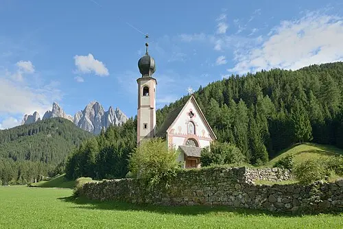 © This Photo was taken by Wolfgang Moroder. Feel free to use my photos, but please mention me as the author and send me… · CC BY-SA 3.0
St. Johann in Ranui
 © Ximonic (Simo Räsänen) · CC BY-SA 4.0
Passo Gardena

 © H. Zell · CC BY-SA 3.0
Passo Sella
 © Pietro De Grandi peter_mc_greats · CC0
Alpe di Siusi
Campsites nearby
- Camping Colfosco - CalfoschCampsite12 km from SecedaTentsCaravansElectricityDrinking waterShowersToiletsWaste disposal
- Ansitz GampCampsite13 km from SecedaTentsCaravansMotorhomesElectricityDrinking waterShowersToiletsWaste disposalWi-Fi
- Parking OdlinaCampsite13 km from SecedaCaravansMotorhomesElectricityShowersDogs allowedWi-Fi
- Campeggio MiravalleCampsite14 km from SecedaTentsCaravansMotorhomesElectricityDrinking waterShowersToiletsDogs allowedWi-Fi
- Zum Vahrner See - Al Lago di VarnaCampsite19 km from Seceda · 50 pitchesTentsCaravansMotorhomesElectricityWaste disposalDogs allowed
- Camping Sass DlaciaCampsite19 km from SecedaTentsCaravansElectricityDrinking waterShowersToiletsWaste disposalWi-Fi
All campsites in Italy · Campsite data: © OpenStreetMap contributors, ODbL 1.0 · Updated October 3, 2026
FAQs
Where is Seceda?
Seceda is in Ortisei, Italy, at GPS 46.5990, 11.7250. It is about 6 km from Funes.
Can you camp near Seceda?
Yes. The nearest campsite listed in OpenStreetMap is Zum Gletscher Hons, about 5 km away; within 25 km there are 27 campsites and motorhome stopovers.
Which road trips pass Seceda?
Seceda is a stop on these CampingSpirit trip guides: Val di Funes, Val Gardena and the Sella passes.
What is there to see near Seceda?
Places worth a stop nearby: St. Johann in Ranui (4 km), Passo Gardena (8 km), Passo Sella (10 km) and Alpe di Siusi (10 km).
When is the best time to visit Seceda?
The most pleasant months are usually June–August. Still fine, with some compromises, in May and September. (Estimate from long-term temperature averages, terrain and pass seasons)