


In-depth guide · CampingSpirit
From Winnipeg via Steinbach, Morden and the borderland of Turtle Mountain to the Spirit Sands: about 740 kilometres of prairie, river valleys, a peace garden and a sand desert in the middle of Manitoba.
The spirit of the route
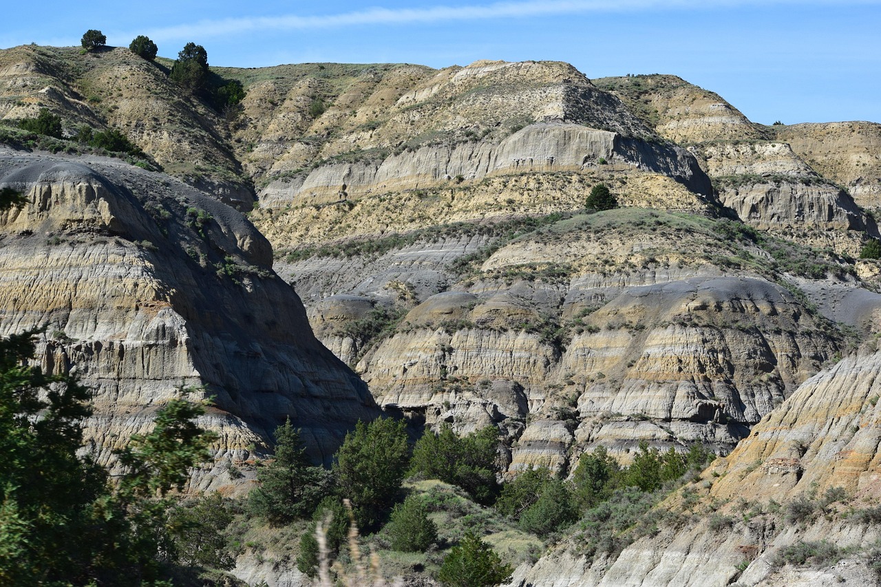
Southern Manitoba is flat, until it isn’t. The road runs dead straight for kilometres, wheat on the left, canola on the right, and then the ground suddenly drops away: the Pembina Valley cuts a green notch into the plain, at Turtle Mountain aspens and lakes stand like an island in the farmland, and at Spruce Woods sand dunes drift over a pine forest, with a small blue-green pond at their foot. In between, a thirteen-metre marine reptile stands in Morden, a Mennonite windmill turns in Steinbach, and in the International Peace Garden the border runs straight through a flower bed. From your sliding door you see deer at the field edge in the morning, thunderclouds towering like skyscrapers at midday, and in the evening a sky so wide that you almost sense the curve of the Earth. The towns are small, the coffee cups are big, and people wave from their pickups.
Stage-by-stage plan
1Stage 1: Winnipeg to Steinbach (approx. 65 km)
- The drive
- Start in Winnipeg, the provincial capital at the confluence of the Red and Assiniboine rivers. Leave the city on the Perimeter Highway (PTH 100/101) and the Trans-Canada Highway heading east, then take PTH 12 south to Steinbach. All flat, two lanes (four within the city), 90–100 km/h, about an hour of pure driving time. Petrol stations and supermarkets everywhere in Winnipeg and Steinbach. Morris (Red River Valley) and Emerson (border town with North Dakota) lie off this line and are only mentioned here: if you have time, you can add both as a detour south along PTH 75.
- Highlights & must-sees
- The Forks in Winnipeg: meeting place at the confluence of the two rivers, a trading site for centuries, now home to a market hall, riverside paths and a skatepark. Right next door is the Canadian Museum for Human Rights, whose tower is a piece of architecture in its own right; a short loop through the foyer is worthwhile even if you have no time for the exhibitions. Check opening hours and admission in advance.
- Mennonite Heritage Village in Steinbach: open-air museum on the history of the Mennonites in Manitoba, with homes, a church, a windmill and a village shop. Seasonal opening hours, check the museum’s website beforehand.
- Steinbach is one of the largest towns in the province and a good place to shop and refuel before heading west.
- CampingSpirit overnight tip
-
Official campsite or RV park: Birds Hill Provincial Park north-east of Winnipeg is the obvious choice for the night before or after the trip: a large provincial park with a campground, a lakeside beach and cycle paths; sites with and without electricity, booking through Manitoba’s Parks Reservation Service recommended. Closer to Steinbach there are municipal and private sites whose facilities you need to check locally.
Free camping or nature tip (where legal): Free camping within towns and in car parks is not permitted; follow the signs and municipal bylaws. There is hardly any Crown land in this farming landscape.
- Insider tip for campers
- Fill up on petrol, water and supplies in Winnipeg: the choice in the small towns further west is much smaller. If you want to leave the vehicle in Winnipeg, use the large car parks at The Forks and walk to the museum.
2Stage 2: Steinbach to Morden / Winkler (approx. 150 km)
- The drive
- From Steinbach take minor roads south-west, then PTH 14 or PTH 3 towards Winkler and Morden. The route is dead straight, through wheat, corn and sunflowers, with small towns every twenty to thirty kilometres. 90–100 km/h, about two hours of pure driving time. The roads are in good condition; in thunderstorms or heavy rain, side roads can briefly be under water. Petrol stations in Steinbach, Winkler and Morden.
- Highlights & must-sees
- Canadian Fossil Discovery Centre in Morden: museum of fossils from the sea that covered southern Manitoba millions of years ago. The centrepiece is a thirteen-metre skeleton of the mosasaur Tylosaurus pembinensis, nicknamed Bruce, the largest specimen of its kind on display. Check opening hours and admission beforehand.
- Winkler: small town with Mennonite roots, murals and a lively centre; the sunflower fields around it bloom in high summer.
- Pembina Valley on the horizon: on the approach you already see the edge of the escarpment, and the landscape becomes hilly.
- CampingSpirit overnight tip
-
Official campsite or RV park: Lake Minnewasta Recreation Area in Morden: campground run by the town of Morden on the reservoir, open all year, with unserviced sites, sites with water and electricity (30/15 A) and full-hookup sites with sewer; some of the sites are reserved for seasonal campers. Whether there is a dump station and how to reserve is not stated on the town’s page: ask the campground office before you arrive. There are alternatives in Winkler and in the villages of the region.
Free camping or nature tip (where legal): Free camping is not permitted in the municipalities. If you want to stay overnight in the region, book a site; in high summer, lakeside sites fill up quickly at weekends.
- Insider tip for campers
- If you are travelling in high summer, expect thunderstorm fronts in the late afternoon. Keep an eye on weather warnings (Environment Canada) and do not park under single tall trees. In case of a tornado: a solid building, not a motorhome, is your shelter.
3Stage 3: Morden to Killarney (approx. 140 km)
- The drive
- From Morden go first to Pembina Valley Provincial Park, reached via PR 432 south of Morden, PTH 31 south of Darlingford or PTH 32 south of Winkler (the park lies on PR 201). Then take PTH 3 west through Manitou to Killarney. Straight plateau, then rolling hills, 90–100 km/h, a good two hours of pure driving time without hiking. Deer at the forest edges near dusk.
- Highlights & must-sees
- Pembina Valley Provincial Park: small park in the valley of the Pembina River with deciduous forest and views across the valley. The park is meant for hiking and nature watching; check trails and lengths on the province’s trail map. The province’s park page lists only hiking and picnicking; no campgrounds are mentioned there.
- Pembina Valley Escarpment: the edge where the prairie drops into the valley offers wide views to the east on clear days.
- Killarney: town on Killarney Lake, with a swimming beach and paths along the water, a quiet start to the evening.
- CampingSpirit overnight tip
-
Official campsite or RV park: Kerry Park on the north side of Killarney Lake: municipal campground with over 100 serviced sites, a boat ramp, showers and washrooms. There are also the Killarney Agricultural Campgrounds, just one street from the main beach. Clarify booking and exact facilities with the municipality beforehand.
Free camping or nature tip (where legal): No campgrounds are designated in Pembina Valley Provincial Park, so do not stay overnight there. Free camping is not usual at the lakes or in the towns; Crown land lies further west at Turtle Mountain.
- Insider tip for campers
- A Park Vehicle Permit is required for day visits to provincial parks, including Pembina Valley Provincial Park (check types and fees on the Manitoba Parks website). Pack insect repellent for the valley forests.
4Stage 4: Killarney to Boissevain (approx. 100 km)
- The drive
- From Killarney head south to Turtle Mountain Provincial Park (access via the provincial roads in the park), then on to the International Peace Garden on the North Dakota border and north along PTH 10 to Boissevain. Winding forest roads in the park, 50–80 km/h, wildlife crossings frequent. Driving time just under two hours. Petrol stations in Killarney and Boissevain, none in the park.
- Highlights & must-sees
- Turtle Mountain Provincial Park: over 200 lakes and wetlands in rolling hills, hiking trails at Adam Lake, a Wildlife Self-guiding Trail and mountain-bike routes. The hills are covered in deciduous forest instead of prairie.
- International Peace Garden: friendship garden on the North Dakota border, founded in 1932, with flower beds, ponds and pavilions on both sides of the border. You first drive through the border station of the country you are entering; in the garden itself you are in neither country, and when you leave you must stop at the border station of the country you are entering. A passport is the preferred document; for visitors who are neither Canadian nor US citizens, the normal entry requirements apply. Check the rules beforehand on the garden’s website and with CBSA/CBP.
- Boissevain: town with the giant turtle “Tommy the Turtle” as its landmark and a small centre with murals.
- CampingSpirit overnight tip
-
Official campsite or RV park: Turtle Mountain Provincial Park: Adam Lake Campground with basic and electrical sites, plus Max Lake and William Lake with basic facilities; Adam Lake also offers group sites; for backcountry overnights there are the Oskar Lake Campsite and the James Lake Cabin. Reservations through the Parks Reservation Service. The International Peace Garden campground is on the American side (North Dakota, near Dunseith), with 36 electric sites and a dump station, open seasonally; the camping fee does not include admission to the garden. Anyone staying there is entering the USA: check the entry requirements beforehand.
Free camping or nature tip (where legal): In the provincial park only on the designated sites. Outside it, the land is mostly private.
- Insider tip for campers
- Plan the Peace Garden for the morning, before the coaches arrive. If you cross the border, clarify the rules for a motorhome (fruit, meat, firewood) with the border authorities beforehand. Ticks are an issue in the forests: check yourself after hikes.
5Stage 5: Boissevain to Brandon (approx. 110 km)
- The drive
- From Boissevain take provincial roads north to the Souris River at Souris, then on to Brandon; the direct route is along PTH 10. Straight route through wheat and canola fields, two lanes, 90–100 km/h, about two hours. In crosswinds, gusts can noticeably push a motorhome around.
- Highlights & must-sees
- Souris Swinging Bridge: a pedestrian suspension bridge about 180 metres long over the Souris River, the town’s landmark; the municipality describes it as the longest pedestrian suspension bridge in Canada. Check condition and access with the municipality.
- Souris itself: small community on the river with a museum and green spaces along the bank.
- Brandon: small western city with the Commonwealth Air Training Plan Museum at the airport, a historic centre and cafés.
- CampingSpirit overnight tip
-
Official campsite or RV park: Souris Campground in Victoria Park in Souris (on Plum Creek, within walking distance of the suspension bridge): over 95 sites with water and 15 A, 30 A or full hookup, pull-through sites, dump station, washrooms; open in the summer half of the year, online booking possible, details from the municipality. In Brandon itself I could not verify a confirmed overnight site: according to the tourism directory, the Riverbank Discovery Centre offers day parking for motorhomes and a dump site, but no campground.
Free camping or nature tip (where legal): Free camping is prohibited or unusual in municipalities. On Crown land, Manitoba conditions apply; ask the province beforehand.
- Insider tip for campers
- Brandon has large supermarkets, petrol stations and propane refillers; top everything up here before heading into the sand hills, where there are no shops. Check the thunderstorm outlook before setting off in the afternoon.
6Stage 6: Brandon to Spruce Woods Provincial Park (approx. 70 km)
- The drive
- From Brandon take the Trans-Canada Highway east, then PTH 5 south to the park. According to the province, the campground is about 180 kilometres from Winnipeg, with access via PTH 5 from Highway 1 (29 kilometres) or from PTH 2 (13 kilometres). Straight, wide roads, 90–100 km/h, about an hour. Smaller roads in the park itself.
- Highlights & must-sees
- Spirit Sands: dune landscape of sand that the winds of the late glacial period piled up from the old delta of the Assiniboine River; partly with pines and juniper, partly bare. Check the trail and its length in the park’s trails guide, and take water and a hat.
- Devil’s Punch Bowl: small blue-green spring-fed pond surrounded by spruce at the foot of the dunes.
- Epinette Creek, Seton and Yellow Quill Trails and the Isputinaw Self-guiding Trail for shorter hikes.
- CampingSpirit overnight tip
-
Official campsite or RV park: Kiche Manitou Campground in Spruce Woods Provincial Park: provincial campground with over 200 sites, electrical and basic, plus group sites and yurts. The province’s park page does not mention a dump station: ask the park office before you travel. Reservations through the Parks Reservation Service. The park also has self-registration sites (Canoe Landing, Equestrian Campground), backcountry sites and the Jackfish Lake Cabin in the Epinette Creek trail network.
Free camping or nature tip (where legal): In the provincial park only on designated sites. Outside it, the land is mostly private.
- Insider tip for campers
- The Park Vehicle Permit applies for day visits here too; check with Manitoba Parks whether it is covered by your campsite. Fire bans are possible in dry summers. Sand and wind make the hike to the Punch Bowl strenuous: start early and take water.
7Stage 7: Spruce Woods to Portage la Prairie (approx. 100 km)
- The drive
- From the park take PTH 5 north to Carberry and on along the Trans-Canada Highway east to Portage la Prairie. Straight, easy, 90–100 km/h, about an hour and a half. If you want to return to Winnipeg, it is a further 85 kilometres or so on the Trans-Canada Highway. Heavy lorry traffic on Highway 1, deer at dusk.
- Highlights & must-sees
- Carberry: small town with a connection to the nature writer Ernest Thompson Seton; the Seton Centre commemorates him. Check opening hours.
- Portage la Prairie: town with Island Park, a lake and paths, and the Fort la Reine Museum.
- The way back to Winnipeg follows the Trans-Canada Highway.
- CampingSpirit overnight tip
-
Official campsite or RV park: In Portage la Prairie I could not verify a confirmed municipal campground; better to plan the night in Spruce Woods or, if you are driving back to Winnipeg, in Birds Hill Provincial Park.
Free camping or nature tip (where legal): Free camping in town is not permitted. The highway rest areas on the Trans-Canada Highway are not campgrounds.
- Insider tip for campers
- Highway 1 is much busier on Friday afternoons and Sunday evenings; if you are flexible, drive in the morning. You will find more prairie and sky in the CampingSpirit guide “Weite, Wind und Sternenhimmel – mit dem Camper durchs Qu’Appelle-Tal und zum Grasslands National Park” (Saskatchewan), forests, bison and lakes in the guide “Bisons, Wälder und kühler See – mit dem Camper durch Riding Mountain und Duck Mountain”, the north in the guide “Sand, Sagen und Seeluft – mit dem Camper durch den Interlake nach Gimli und Hecla Island”, and granite and loons in the guide “Granit, Wasser und Loons – mit dem Camper durch Whiteshell und an den Lake of the Woods”.
Camping practice & local rules
Wild camping & overnight parking
- In Manitoba, camping on Crown land outside provincial parks, national parks and private land is possible in principle, with conditions (duration, fire, distance from water, take your rubbish with you). On this route almost everything is farmland and provincial parks; free camping is practically impossible here.
- In the provincial parks (Turtle Mountain, Spruce Woods) you may only stay overnight on the designated sites; no campgrounds are designated in Pembina Valley Provincial Park. A Park Vehicle Permit is required for day visits (types, validity and fee on manitoba.ca).
- Reservations through Manitoba’s Parks Reservation Service; reservation fees and site fees are listed on the province’s pages. In summer, especially at weekends, book early.
- Mosquito plague: in June and July, mosquitoes and black flies are very active, especially near water and in the woods. Plan for insect repellent, a mosquito net and light-coloured long clothing.
- Thunderstorms and tornadoes: the season runs from June to August, with late afternoons as the high-risk time. Monitor Environment Canada weather warnings and, if in doubt, seek a solid building.
- Wildlife: black bears occur occasionally; deer, moose and coyotes are common. Deer cross the roads at dusk.
- Apps and sites: iOverlander, Campendium, Park4Night, plus manitobaparks.com and 511 Manitoba for road conditions.
Waste disposal & supplies
- You will find dump stations in the larger parks and in some towns; check directories such as Sanidumps and the park pages, as details change.
- Drinking water is available at serviced campgrounds and in the towns; in the provincial parks bring containers, and filter lake water.
- Do not drain grey water; empty chemical toilets only at dump stations.
- Propane in Winnipeg, Steinbach, Winkler, Brandon and Portage la Prairie at dealers and petrol stations; European cylinders need an adapter.
- Fuel: Winnipeg, Steinbach, Winkler, Morden, Killarney, Boissevain, Brandon, Carberry, Portage la Prairie; on the minor routes, petrol stations are far apart.
- Shopping: supermarkets in Winnipeg, Steinbach, Winkler, Brandon and Portage la Prairie.
Vehicle size & traffic rules
- Speed limits: generally 90 km/h on provincial roads and 100 km/h on highways, much lower in parks; follow the signs. Motorhomes have no separate limit.
- Long straight roads: watch for fatigue and wind gusts with tall vehicles; take regular breaks.
- There are no tolls on this route. There are no low-emission zones.
- North Dakota border: according to North Dakota Tourism, the International Peace Garden may be visited without a passport (for Canadians and US citizens, photo ID and a birth certificate suffice); anyone continuing into the other country afterwards needs the entry documents valid there. For visitors from Europe the normal entry requirements apply: check with CBSA and CBP beforehand. Food (fruit, meat, firewood) can be challenged at the border.
- Alcohol in the vehicle only if sealed; cannabis is legal in Canada but remains prohibited at the border.
- Deer and moose at dusk: drive very slowly at night, use high beam where possible.
CampingSpirit packing & preparation checklist
- Insect repellent and mosquito net: in June and July, mosquitoes and black flies are very active near water and in the woods.
- Weather app and offline warnings (Environment Canada): thunderstorm and tornado warnings come quickly in summer.
- Sun hat, water and sturdy shoes for Spirit Sands: sand and heat make the hike to Devil’s Punch Bowl strenuous.
- Passport and documents for the Peace Garden: the border runs right through the garden, and on the way out you stop at the border station.
- Park Vehicle Permit and reservation confirmations to hand, printed or digital depending on the province’s requirements.
- Binoculars: birds at Turtle Mountain, deer at the field edge.
As of 2026-10. Closures, fees and booking rules change: check official sources before you go.