

In-depth guide · CampingSpirit
From Rodez via the bridge towns on the Lot up onto the Aubrac plateau and over to Chaudes-Aigues and the Garabit Viaduct: around 285 kilometres on back roads where cows have right of way and the weather changes faster than the landscape.
The spirit of the route
The Lot valley is narrow, green and quiet: slate roofs, Gothic bridges, church towers reflected in the river, and on the banks the scallop-shell signs of the pilgrims who have walked from Le Puy to Conques for centuries. Then the road climbs out of the chestnut woods, the hedges disappear, and up top lies the Aubrac – a largely treeless plateau at 1,200 to 1,400 metres, granite and basalt, drystone walls, meadows of narcissi and light-brown cattle with curving horns and dark-rimmed eyes. From the sliding door you see nothing but open space, abandoned shepherds’ huts and cloud shadows drifting across the pastures. Nights are cool and very dark, and in the mornings mist often hangs in the hollows. This loop thrives on contrasts: knife forges and aligot, Romanesque churches and a spring at 82 degrees, pilgrim silence and cowbells – and at the end Eiffel’s red iron-arch viaduct over the Truyère.
Stage-by-stage plan
1Stage 1: Rodez to Conques (Saint-Cyprien-sur-Dourdou) (approx. 45 km)
- The drive
- Head north out of Rodez on the D901 across the limestone plateau (causse) to Salles-la-Source, then on into the wine valley of Marcillac-Vallon and along the Dourdou via Saint-Cyprien to Conques. The road is well built, more winding and narrower in the Dourdou valley; the final approach to Conques twists through a wooded gorge. A good hour’s driving time.
- Highlights & must-sees
- Musée Soulages in Rodez: the Corten steel cube by the Foirail garden with works by Pierre Soulages, including the designs for the stained-glass windows of Conques. Right next to it is the red sandstone Notre-Dame cathedral with its bell tower of around 87 m.
- Salles-la-Source: the village clings to a cliff face, and in the middle of it a waterfall plunges out of the limestone; the Musée du Rouergue Arts et Métiers shows the region’s old crafts.
- Conques – only briefly, as it is covered in more detail in the CampingSpirit guide to Périgord, the Dordogne valley and the Lot: the abbey church of Sainte-Foy with its Last Judgement tympanum and the Soulages windows, car-free lanes, pilgrim bridge over the Dourdou.
- CampingSpirit overnight tip
-
Official campsite or RV park: Aire at Saint-Cyprien-sur-Dourdou (“La Citarelle”, commune of Conques-en-Rouergue), around 8 km before Conques: about 12 hard-standing, lit pitches up to 8 m long in a quiet, park-like setting, water and electricity for a fee from the bollard, grey water and cassette free. In Conques itself, the campsite Le Temps d’une Pause lies close to the village; the tourist office names it as the alternative when the visitor car park is closed to motorhomes in summer.
Free camping or nature tip (where legal): In Conques, five spaces for motorhomes are marked in the lower part of the La Salesse visitor car park, but they are not allowed there in summer; campers then have to move to the La Rivière car park around 2 km below. The village and its surroundings are protected (Monuments historiques, Unesco World Heritage on the Way of St James) – wild camping is out of the question here. In Rodez the car parks near the centre have height restrictions; a small municipal aire with a few spaces lies on the eastern edge of town, check its status beforehand.
- Insider tip for campers
- Rodez is the last larger supply point before the plateau: supermarkets with fuel stations and French exchange gas bottles on the outskirts. Don’t expect motorhome parking in the old town – better to park on the edge of town and walk or take the town bus into the centre. Marcillac-Vallon has an aire with water and waste disposal, handy as a stopover; this is where Marcillac red wine grows from the Mansois grape.
2Stage 2: Conques to Entraygues-sur-Truyère (approx. 35 km)
- The drive
- From Conques down to the Lot at Grand-Vabre and then upstream through the narrow, wooded Lot valley to Entraygues. The valley road is narrow, with rock overhangs, few passing places and oncoming timber lorries – drive slowly; for larger motorhomes it is tiring but doable. Around an hour’s driving.
- Highlights & must-sees
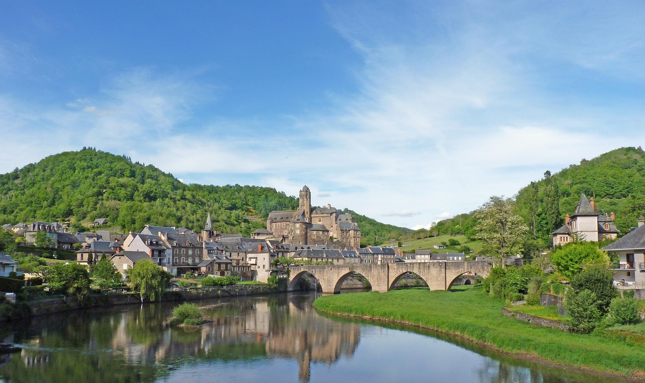
- Entraygues lies at the confluence of the Lot and the Truyère: a 13th-century Gothic bridge over the Truyère, a château at the tip where the rivers meet (private) and the Rue Basse with its overhanging half-timbered houses.
- Vineyards on the schist terraces around Entraygues and Le Fel – small wine-growing areas with white wines from Chenin; some winemakers sell directly from the estate.
- Swimming spots and canoe launch points on the Lot below the town in summer.
- CampingSpirit overnight tip
-
Official campsite or RV park: Camping Le Val de Saures on the right bank of the Truyère, linked to the town by a footbridge: electricity, washblock, water and waste disposal, open seasonally. Next to it is a municipal aire for motorhomes; check facilities and fees on site.
Free camping or nature tip (where legal): The banks of the Lot and the Truyère are largely private or designated as flood zones; the Truyère reservoirs above Entraygues are managed by EDF, and the water level can change quickly. Spending the night on the riverbank is therefore not a good idea – on the aires you are legal and safe.
- Insider tip for campers
- Don’t drive the motorhome into the Rue Basse and the old town of Entraygues – narrow lanes with nowhere to turn. Some of the bridges over the Truyère have width or weight restrictions; watch for the signs before the approach. Fill up with water here for the next stage.
3Stage 3: Entraygues-sur-Truyère to Saint-Côme-d’Olt via Estaing and Espalion (approx. 35 km)
- The drive
- Take the D920 upstream through the Lot gorge to Estaing, then continue in the wider valley to Espalion and on the D987 to Saint-Côme-d’Olt. Winding with rock walls as far as Estaing, relaxed after that. Just under an hour without stops.
- Highlights & must-sees
- Estaing: the château of the d’Estaing family above the Lot and the Gothic bridge with the statue of Bishop François d’Estaing – the bridge is part of the Unesco World Heritage site “Routes of Santiago de Compostela in France”.
- Espalion: the Pont-Vieux, also Unesco World Heritage, with the old tanners’ houses on the bank and the Renaissance Vieux Palais; a little outside town, the Romanesque Église de Perse in red sandstone with a portal full of figures.
- Saint-Côme-d’Olt: walled village with a twisted, “flaming” slate church spire.
- CampingSpirit overnight tip
-
Official campsite or RV park: Camping Belle Rive on the Lot in Saint-Côme-d’Olt with electricity, washblock and water and waste disposal, seasonal; next to it a small municipal aire. In Espalion there is an aire with water and waste disposal near the river and Camping Roc de l’Arche on the bank of the Lot, both within easy walking distance of the Pont-Vieux.
Free camping or nature tip (where legal): Around the bridges, churches and châteaux, wild camping is banned within 500 m of Monuments historiques – which covers the centres of Estaing, Espalion and Saint-Côme entirely. Overnight parking in public car parks is only allowed where no municipal bylaw prohibits it and no camping behaviour is visible; the aires are the better choice.
- Insider tip for campers
- Espalion has a traditional weekly market on the Place du Marché on Friday mornings, plus a market with regional produce on Tuesday mornings – on market days the central car parks fill up early. Estaing has hardly any room for motorhomes in the village; park on the edge and walk over the bridge. Fill up and shop in Espalion: there are only a few fuel stations on the plateau.
4Stage 4: Saint-Côme-d’Olt to Laguiole (approx. 30 km)
- The drive
- Back to Espalion and up the D921 in long, well-built bends out of the Lot valley to around 1,000 m at Laguiole. The road is wide and busy, and up top a strong wind often blows. About 40 minutes.
- Highlights & must-sees
- Laguiole: knife forges and workshops in and around the town; in several ateliers you can watch the grinding and assembly. You’ll recognise the Forge de Laguiole on the edge of town by the giant steel blade on the building.
- Coopérative Jeune Montagne: most Laguiole AOP is made here, along with tome fraîche for aligot; shop and a look into the cheese dairy.
- Bronze bull on the Foirail in the town centre – a monument to the Aubrac cattle once traded here at the livestock market.
- CampingSpirit overnight tip
-
Official campsite or RV park: Camping municipal Les Monts d’Aubrac on the Puech du Gridou above the town, a few minutes’ walk from the centre, with electricity and heated washblock, open seasonally; the motorhome service point lies outside the site and is chargeable. Usable all year is the aire “La Montagnette” on a farm around 4 km outside town: pitch free, water free, electricity and cassette emptying for a fee, no grey-water disposal; farm shop with regional produce. Book ahead for the transhumance weekend. Around 10 km above the town, the car park of the Bouyssou ski station at about 1,200 m also offers some 20 year-round spaces with water and optional electricity, but no grey-water or cassette disposal – the nearest service point is the one at the campsite in Laguiole.
Free camping or nature tip (where legal): In town, motorhome parking is expressly allowed in the car park opposite the Coopérative Jeune Montagne – parking only, without camping behaviour. Outside town, almost all land is private pasture.
- Insider tip for campers
- Laguiole is packed in July and August: arrive in the morning, leave the camper in the permitted car park and explore on foot. When buying a knife, check the maker – “Laguiole” mainly denotes a knife shape, and many cheap knives of that name do not come from the town. Farm and producer stopovers with cheese or meat from the Aubrac are in the France Passion guide; apart from the cooperative, only a few farms make Laguiole AOP.
5Stage 5: Laguiole to Nasbinals via Aubrac and Saint-Chély-d’Aubrac (approx. 45 km)
- The drive
- Across the open plateau to the village of Aubrac (around 1,300 m), from there down the D987 to Saint-Chély-d’Aubrac and back up again, then across the plateau over to Nasbinals in the Lozère. Narrow but well-surfaced roads without crash barriers, with cattle grids (passages canadiens), gates and cattle on the road. Around 1.5 hours with short stops.
- Highlights & must-sees
- Aubrac village: the medieval Domerie, a hospice for pilgrims on the Way of St James, with its church and the massive “Tour des Anglais”; plus the Maison de l’Aubrac with an exhibition on cattle breeding, burons and transhumance, and a small botanical garden with plants of the plateau.
- Burons: low stone huts with lauze roofs where shepherds used to make cheese in summer. Some are now seasonal excursion restaurants serving aligot, others are crumbling on the pastures. Traditionally the herds move on foot to the summer pastures at the end of May and back in autumn – transhumance still shapes the plateau today.
- Saint-Chély-d’Aubrac: the stone pilgrim bridge over the Boralde with a wayside cross depicting a pilgrim with a staff.
- CampingSpirit overnight tip
-
Official campsite or RV park: Camping municipal of Nasbinals on the edge of the village, with electricity, washblock and water and waste disposal, open seasonally; Saint-Chély-d’Aubrac has a small, simple campsite – check season and facilities beforehand.
Free camping or nature tip (where legal): The Aubrac is a Parc naturel régional, not a national park – general French rules apply, but almost every piece of land is private pasture, and driving motor vehicles on farm tracks and pastures is prohibited under the Environmental Code. Sleeping in the vehicle is possible in permitted car parks; camping in the countryside counts as wild camping and can be fined during checks. Around the Domerie and church of Aubrac, the 500 m protection radius of the Monuments historiques also applies.
- Insider tip for campers
- Cattle on the road: walking pace, no horn, keep your distance – suckler cows with calves defend their young, and bulls often stand in the middle of the herd. Take cattle-grid crossings slowly, always close gates on footpaths behind you and keep dogs on a lead. In Aubrac the car parks are full during the day in season; come early.
6Stage 6: Nasbinals to Chaudes-Aigues via Lac de Saint-Andéol, Cascade du Déroc and Saint-Urcize (approx. 55 km)
- The drive
- From Nasbinals take the D52, the Route des Lacs, across the plateau to Lac de Saint-Andéol and back, stopping at the Cascade du Déroc on the way; then from Nasbinals over the border into the Cantal to Saint-Urcize, a granite village on the edge of the plateau whose Romanesque church has an ambulatory unusual for a village church; from there down through deep forests into the Remontalou valley to Chaudes-Aigues. Narrow and lonely up top, with cattle grids and cattle; the descent to Chaudes-Aigues is winding. Around 1.5 to 2 hours’ driving time.
- Highlights & must-sees
- Lac de Saint-Andéol: a small glacial lake at around 1,200 m surrounded by legends – of a sunken town and of pagan offerings that pilgrims once threw into the water. A short walk across the pasture from the car park.
- Cascade du Déroc: the stream plunges around 32 m over an edge of basalt columns; beneath the edge is a small cave, and an unsecured path lets you get behind the waterfall – only if you are sure-footed. Hiking trails lead there from Nasbinals and from Marchastel; the starting point for the short approach is a car park on the D52.
- Chaudes-Aigues: the Source du Par emerges at around 82 °C – the hottest thermal spring in Europe. The water has heated houses in the town since the Middle Ages; the Géothermia museum explains the technology.
- CampingSpirit overnight tip
-
Official campsite or RV park: Motorhome aire in Chaudes-Aigues with water and waste disposal, or Camping Le Couffour on the southern edge of town, with electricity and washblock, seasonal. After a day on the windy plateau, the Caleden thermal baths in town are worth it.
Free camping or nature tip (where legal): Overnight stays are not intended at Lac de Saint-Andéol or at the waterfalls: the land is pasture or protected area (Natura 2000), and the car parks are small and busy during the day. The shores of mountain lakes and bogs are sensitive – don’t drive up to the water.
- Insider tip for campers
- There is often no mobile signal on the plateau. Download offline maps and check before setting off whether the road towards Saint-Urcize is clear – in fog or snow it is lonely. The lanes of Chaudes-Aigues are narrow; don’t take the motorhome into the old town, park at the aire and walk to the spring.
7Stage 7: Chaudes-Aigues to Viaduc de Garabit (approx. 40 km)
- The drive
- On the D921 north out of the valley up onto the plateau towards Saint-Flour, then east on back roads down to the Grandval reservoir, whose upper arm the viaduct spans. Well built, with some bends. About an hour.
- Highlights & must-sees
- Viaduc de Garabit: the railway bridge over the Truyère by Gustave Eiffel’s company, completed in 1884, around 565 m long and around 122 m high – at its finest in the evening, when the red arch catches the light.
- Viewpoints on the shore of the reservoir and on the roads above the valley with views of the viaduct.
- Boat trips on the Garabit-Grandval reservoir in season.
- CampingSpirit overnight tip
-
Official campsite or RV park: Camping Le Petit Bois in Ruynes-en-Margeride, a few kilometres from the viaduct, with electricity and washblock, seasonal; Ruynes also has a motorhome service point. From here it is not far via the A75 to Saint-Flour with its basalt upper town.
Free camping or nature tip (where legal): The shore zones of the reservoir are the operator’s flood and protection zone; overnight stays are not tolerated at the viaduct or in the visitor car parks. For a quiet night, use the aires and campsites in Ruynes or Saint-Flour.
- Insider tip for campers
- The A75 is toll-free between Clermont-Ferrand and the south except for the Millau Viaduct – ideal for the journey home northwards. If you are continuing south, fuel is cheaper at the A75 service areas than on the plateau.
Camping practice & local rules
Wild camping & overnight parking
- In France a motorhome counts as a vehicle and may park anywhere parking is allowed (for up to seven days in the same place), unless a municipal bylaw (arrêté) prohibits it. Camping behaviour – levelling jacks, awning, table and chairs, draining water – is prohibited outside campsites and aires.
- Wild camping is banned in Sites classés, within 500 m of Monuments historiques and near drinking-water catchments, among other places. On this route that affects the centres of Rodez, Conques, Estaing, Espalion, Saint-Côme, Aubrac and Saint-Urcize.
- The Parc naturel régional de l’Aubrac is not a national park and has no core zone with its own rules. But almost all the land is private pasture, parts of the plateau are Natura 2000 sites, and driving motor vehicles on tracks off public roads is prohibited. Camping in the countryside is treated as wild camping; fines are possible during checks.
- You can stay legally on the municipal aires, on campsites and on farms. France Passion lists producers of cheese, beef, wine and knives in the Aveyron, the Lozère and the Cantal; you can also find spots via park4night and Campercontact.
Waste disposal & supplies
- A service point is called an “aire de services” or “borne”; Euro-Relais, Flot Bleu and Raclet bollards are common, paid by card, token or free. Farm and ski-station aires on the plateau sometimes have no grey-water disposal – empty at a station in the valley beforehand.
- Empty grey water and cassettes only at the service point – on the pastures, at the lakes and bogs of the Aubrac and in the streams the cattle drink from, dumping is particularly harmful.
- Tap water is drinkable; cattle troughs and springs on the pastures are not drinking water. There are only a few fuel stations and shops on the plateau – stock up in Rodez, Espalion or Saint-Flour.
- Gas: French exchange bottles (butane/propane) are available at almost every supermarket; foreign bottles are not exchanged. LPG pumps for filling refillable bottles (Dish or Euronozzle adapter) are thin on the ground in the region. Because of the cold nights on the plateau, use propane rather than butane – butane barely vaporises below about 0 °C.
Vehicle size & traffic rules
- Speed limits: motorhomes and outfits up to 3.5 t as for cars – 130 km/h on motorways, 110 on dual carriageways, 80 on country roads (90 only where signed, for example on some sections in the Cantal), 50 in built-up areas; in rain 110/100/80. Motorhomes over 3.5 t: motorways 110, dual carriageways with separated lanes 100, other roads 80, with a speed-limit disc on the rear. Outfits over 3.5 t: 90/90/80.
- Tolls: the A75 is toll-free except for the Millau Viaduct, as is the A20 between Vierzon and Brive; the ASFA classes apply to the Millau Viaduct – motorhomes over 2 m and under 3 m high up to 3.5 t in class 2, from 3 m high or over 3.5 t in class 3.
- Low-emission zones: there is no known ZFE on this route. If you arrive via Toulouse: the ZFE inside the Périphérique and the Rocade Arc-en-Ciel excludes Crit’Air 4, 5 and vehicles without a sticker, motorhomes included. The Crit’Air sticker also applies to foreign vehicles and should be on board.
- Vehicles over 3.5 t, expressly including motorhomes, need the “Angles morts” blind-spot stickers (€135 fine). A high-visibility vest for the driver and a warning triangle are compulsory.
- Winter: the Aubrac lies above 1,000 m, snow and black ice are possible from November to April, and back roads are not always cleared; then there is the snowstorm wind known as the “Écir”. Under the Loi Montagne, from 1 November to 31 March winter tyres or carried chains or snow socks are compulsory in the mountain communes designated by prefectoral decree – this affects the north of the Aveyron including the Aubrac, as well as communes in the Lozère and the Cantal, not the whole département in each case. The B58/B59 signs at commune boundaries are what count.
- Alcohol limit 0.5 per mille (0.2 for probationary drivers and during accompanied driving); using a hand-held phone and wearing headphones at the wheel are prohibited.
CampingSpirit packing & preparation checklist
- Warm layers, a hat and a rain jacket: on the plateau temperatures drop into single figures at night even in summer, and wind and fog roll in quickly.
- Propane in a French exchange bottle or a full refillable bottle – butane fails on cold plateau nights, and filling stations are rare.
- Offline maps and printed directions: there are large dead zones between Aubrac, Nasbinals and Saint-Urcize.
- Sturdy, waterproof hiking boots and gaiters for wet pastures, bogs and the path to the Cascade du Déroc.
- A cool box or large fridge compartment for Laguiole AOP, tome fraîche and Aubrac beef from the farms.
- Levelling ramps – the farm and village aires on the edge of the plateau are often on a slope.
As of 2026-10. Closures, fees and booking rules change: check official sources before you go.