


In-depth guide · CampingSpirit
From Darwin via Litchfield, Adelaide River and Nitmiluk Gorge to the warm springs of Mataranka, then via Pine Creek on the Kakadu Highway to Cooinda, Jabiru and Ubirr and back across the Mary River wetlands: around 1,430 km of tropics, where the season decides which road is open and where you may swim.
The spirit of the route
The Top End doesn’t have four seasons but two – and in between the “build-up”, when the clouds tower and the air stands still. In the dry season the morning sky is cloudless, waterfalls plunge from the sandstone plateaus of Litchfield into green pools, and termite mounds stand in the clearings like gravestones, all aligned to the north. From the sliding door you see pandanus, paperbarks and water buffalo tracks; in the evening black kites circle over the bushfire smoke. Then the big pictures: the rock walls of Nitmiluk Gorge in the morning light, the clear, warm water of Bitter Springs, tens of thousands of waterbirds at Yellow Water, rock paintings at Ubirr older than any cathedral, and the sunset over the floodplain. And always the knowledge that a saltwater crocodile may be lying beneath any calm water surface. This route demands respect for water, heat and country – and rewards you with a landscape that is flooded anew every year.
Stage-by-stage plan
1Stage 1: Darwin to Litchfield National Park (Florence Falls) (approx. 130 km)
- The drive
- Leave Darwin south on the Stuart Highway through Palmerston and the bushland of Coolalinga; after a good 80 km turn right onto Batchelor Road and continue through Batchelor onto Litchfield Park Road. All sealed, two lanes, 110 km/h outside towns, much less inside the park. In the park the road first climbs hilly terrain onto the Tabletop plateau, then you take the spur road to Florence Falls. Just under 2 hours of pure driving time.
- Highlights & must-sees
- Magnetic Termite Mounds: hundreds of flat, north-south-aligned termite mounds on a plain, plus a large cathedral termite mound on the interpretive trail.
- Florence Falls: twin falls into a pool enclosed by monsoon forest, reached via a long staircase or the gentler Shady Creek Walk; swimming permitted in the dry season.
- Buley Rockhole: a chain of small rock pools in the creek, full in the afternoon, almost empty early in the morning.
- CampingSpirit overnight tip
-
Official campsite or RV park: Florence Falls Campground run by NT Parks, with a separate area for 2WD vehicles and caravans and a 4WD area closer to the creek: toilets, showers, wood barbecues, no power; boil the water before drinking. Book and pay for sites in advance online via NT Park Bookings. If you need power and a dump point, stay at Litchfield Tourist Park on Litchfield Park Road, around 14 km past Batchelor towards the national park.
Free camping or nature tip (where legal): In the national park you may only stay overnight at designated campgrounds; car parks at waterfalls and lookouts are not overnight spots, and rangers check. In Darwin and Palmerston, council by-laws prohibit sleeping in vehicles on public land – plan your first night at a campground.
- Insider tip for campers
- In Darwin, fill up, buy food and water, and purchase the NT Parks Visitor Pass online in advance – it is compulsory for visitors from other states and from overseas and covers Litchfield, Nitmiluk, Elsey and Mary River, but not Kakadu. In the dry season the pools fill up with day-trippers from Darwin from late morning; an early start pays off.
2Stage 2: Florence Falls to Adelaide River (approx. 130 km)
- The drive
- Continue west on Litchfield Park Road to the Tolmer Falls lookout and down to Wangi Falls, then back the same way to Batchelor and via Batchelor Road onto the Stuart Highway south to Adelaide River. Sealed; in the park, tight crests and one-way car parks. A good 2 hours of pure driving time, a full day with swimming stops.
- Highlights & must-sees
- Tolmer Falls: viewing platform above the gorge with the falls; swimming is prohibited here, and the caves are a refuge for rare bats.
- Wangi Falls: two falls into a large pool, short walk to the treetop lookout in the monsoon forest. Swim only when the pool has been declared open after crocodile checks.
- Adelaide River War Cemetery: well-kept war cemetery with the graves of those killed in the 1942 air raids on Darwin.
- CampingSpirit overnight tip
-
Official campsite or RV park: At the Adelaide River rodeo and show grounds, the local show society (Adelaide River Show Society) runs a simple campground on the edge of town with powered and unpowered sites, showers, toilets and a pool; no reservations, call ahead – uncomplicated and central. Alternative: Wangi Falls Campground in the park (caravans possible, showers, kiosk in season, book online in advance) if you’d rather end the day in the park.
Free camping or nature tip (where legal): Between Batchelor and Katherine there are several signposted rest areas on the Stuart Highway where overnight stays are generally tolerated unless a no-camping sign is posted – usually with a shade roof, table and bin, toilets only at some. Keep your distance from the road; road trains also run at night.
- Insider tip for campers
- After the wet season, the park authority only opens the Wangi Falls pools once floodwaters have receded and crocodiles have been trapped; in the wet season swimming there is closed altogether. Check the current status on the NT Parks “Check if park is open” page. Take the Reynolds River Track with Tjaynera Falls only in an approved 4WD – river crossings and corrugations.
3Stage 3: Adelaide River to Nitmiluk (Katherine Gorge) (approx. 235 km)
- The drive
- Instead of staying on the Stuart Highway, from Adelaide River it’s worth taking the sealed Old Stuart Highway (Dorat Road) past Robin Falls to Hayes Creek – narrow, no shoulders, but quiet. Continue on the highway via Pine Creek (covered in more detail on the way back) and through open savanna country to Katherine, then 30 km on Gorge Road to the Nitmiluk Visitor Centre. A good 3 hours of driving.
- Highlights & must-sees
- Robin Falls: short, rocky path to a small waterfall that is down to a trickle in the late dry season.
- Katherine Hot Springs: warm, clear spring pools on the Katherine River on the edge of town, free to access, with steps into the water.
- Baruwei Lookout Walk at the Nitmiluk centre: steep climb to a view over the first gorge.
- CampingSpirit overnight tip
-
Official campsite or RV park: Nitmiluk Campground right by the visitor centre at the gorge entrance: powered and unpowered sites, amenities, pool, kiosk, starting point for boat tours and canoe hire. Run by a Jawoyn company, the traditional owners of the park. Book early in the dry season; Katherine itself has several full-service caravan parks.
Free camping or nature tip (where legal): In Nitmiluk National Park, only at the campground. The town of Katherine prohibits camping on public land by by-law; car parks at the Hot Springs and along the riverbank are not meant for overnight stays.
- Insider tip for campers
- Book boat tours into the second and third gorges and day canoes in advance – in the dry season the morning departures sell out quickly. Katherine has the last large supermarkets before Kakadu; fill up and swap or refill your gas bottle. In the wet season the Katherine River can burst far beyond its banks, which restricts boat tours and affects parts of Gorge Road.
4Stage 4: Nitmiluk to Mataranka (Bitter Springs) (approx. 135 km)
- The drive
- Back to Katherine and southeast on the Stuart Highway through limestone country with open eucalypt woodland to Mataranka, then a few kilometres on Martin Road to Bitter Springs. Straight, flat road with lots of road train traffic. Around 1.5 hours.
- Highlights & must-sees
- Early canoe trip or boat tour in Nitmiluk Gorge before the heat builds – sandstone walls, rock paintings on the banks, freshwater crocodiles on the sandbanks.
- Bitter Springs in Elsey National Park: turquoise spring-fed creek with water over 30 °C under palms, where you drift along on a pool noodle.
- Mataranka Thermal Pool at Mataranka Homestead, with the replica of the Elsey Homestead from “We of the Never Never”.
- CampingSpirit overnight tip
-
Official campsite or RV park: Bitter Springs Cabins & Camping is a few minutes’ walk from the springs: powered and unpowered sites, amenities, camp kitchen, dump point at the entrance. Alternatively Mataranka Homestead Tourist Resort right by the thermal pool, or Jalmurark Campground (12 Mile Yards) in Elsey National Park on the Roper River – simpler, quiet, with showers; book in advance via NT Park Bookings.
Free camping or nature tip (where legal): Overnight stays are not permitted at Bitter Springs or the Thermal Pool; both are day-use areas of the national park. Rest areas on the Stuart Highway between Katherine and Mataranka can be used for one night unless signposted otherwise.
- Insider tip for campers
- The car park at Bitter Springs is small; better to leave large vehicles at the campground and walk. Don’t apply sunscreen just before swimming in the spring water, and don’t climb over the bank reinforcements. Saltwater crocodiles live in the Roper River and the side waters around Elsey – swim only at the approved springs.
5Stage 5: Mataranka to Pine Creek (via Leliyn / Edith Falls) (approx. 235 km)
- The drive
- Back north on the Stuart Highway through Katherine; 40 km past town turn right onto the sealed Edith Falls Road (around 20 km) to Leliyn. Then back to the highway and on to Pine Creek. Almost all straights, but heat and glare in the afternoon. About 3 hours.
- Highlights & must-sees
- Leliyn (Edith Falls): large pool beneath a waterfall right by the car park, usually open for swimming in the dry season.
- Leliyn Loop Walk to the upper pool with views over the plateau – walk it in the morning, the trail has no shade.
- Pine Creek: gold-mining town with a railway station museum of the old North Australia Railway and a lookout over the flooded open-cut pit; hooded parrots live in the town’s trees.
- CampingSpirit overnight tip
-
Official campsite or RV park: In Pine Creek, Lazy Lizard Caravan Park & Tavern and Pine Creek Railway Resort offer powered sites and amenities – small, relaxed places. If you want to sleep by the water, stay at the NT Parks Leliyn Campground with showers, a kiosk in season and sites for caravans too; book in advance.
Free camping or nature tip (where legal): Leliyn is a national park: overnight stays only at the campground. Pine Creek has no tolerated free camping spot in town; there are rest areas on the Stuart Highway between Katherine and Pine Creek.
- Insider tip for campers
- Fill up and stock up on water in Pine Creek: there is no reliable supply on the Kakadu Highway as far as Cooinda. For Kakadu, buy the Parks Australia park pass online (valid for 7 days, free for NT residents) or get it at the Katherine Visitor Centre – it is separate from the NT Parks pass.
6Stage 6: Pine Creek to Cooinda (Yellow Water) (approx. 160 km)
- The drive
- Northeast on the sealed Kakadu Highway through hilly savanna country, across the park’s southern boundary and through the South Alligator River valley, past the sandstone backdrop of the Arnhem Land escarpment to the turn-off for Cooinda. Narrow in places, no shoulders, with dips and single-lane bridges. A good 2 hours.
- Highlights & must-sees
- Bukbukluk Lookout: short stop with views over the hilly south of Kakadu.
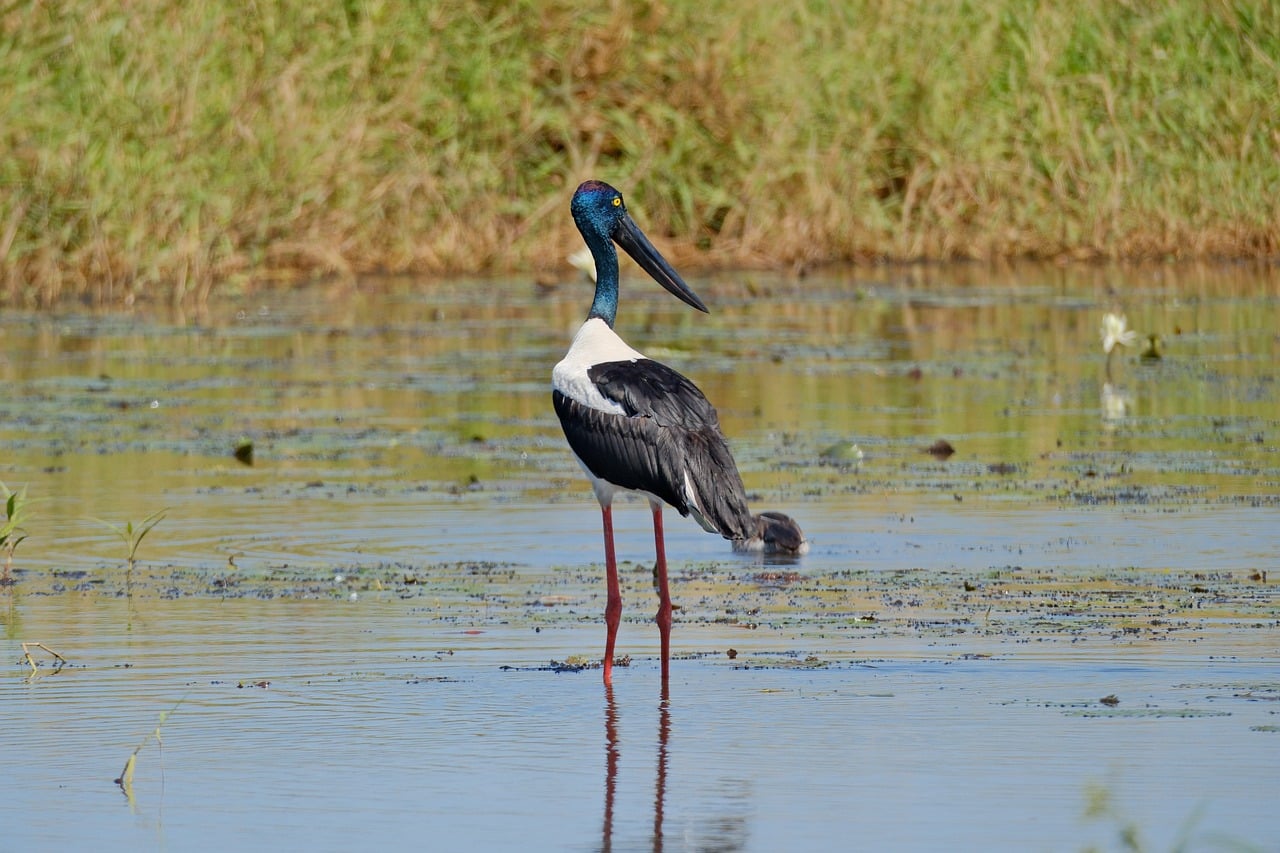
- Yellow Water cruise (Ngurrungurrudjba) at sunrise or sunset: saltwater crocodiles, jabirus, sea eagles, magpie geese and lotus on the billabong.
- Short walk along Home Billabong in Cooinda to the lookouts over the wetlands.
- CampingSpirit overnight tip
-
Official campsite or RV park: Cooinda Lodge Kakadu with a large camping area: powered and unpowered sites, amenities, pool, restaurant, fuel station and shop, departure point for the Yellow Water boats. A few kilometres away is the Parks Australia Mardukal Campground with showers and toilets, no power – simpler, quieter and usually accessible in the wet season too.
Free camping or nature tip (where legal): In Kakadu, overnight stays are only permitted at designated campgrounds; parking up at lookout car parks, billabongs or on tracks is prohibited. The remote bush campgrounds are mostly reachable only via unsealed tracks, which rental campervans are generally not allowed to drive.
- Insider tip for campers
- Gunlom (access for high-clearance 4WDs only), Maguk and Jim Jim lie on unsealed tracks; in 2026 Jim Jim Falls, Twin Falls and Karnamarr campground were closed during roadworks. Check the Parks Australia Kakadu Access Report before every trip. Book the Yellow Water cruise in advance – the early departures are the most popular.
7Stage 7: Cooinda to Ubirr (via Burrungkuy and Jabiru) (approx. 115 km)
- The drive
- North on the Kakadu Highway, detour on the sealed spur road to the Burrungkuy (Nourlangie) rock massif, on to Jabiru and along the road towards Oenpelli to Ubirr. Sealed, flat, but in the dry season lots of buses and hire cars at the car parks. Just under 2 hours without stops.
- Highlights & must-sees
- Burrungkuy (Nourlangie): the Anbangbang rock gallery with depictions of Namarrgon, the Lightning Man, and Gunwarrdehwarrde Lookout over the escarpment.
- Bowali Visitor Centre in Jabiru: exhibition on country, the seasons and the Bininj/Mungguy, the traditional owners – visit before Ubirr.
- Ubirr: X-ray style rock paintings on the overhangs and sunset from Nadab lookout over the floodplain.
- CampingSpirit overnight tip
-
Official campsite or RV park: Parks Australia Merl Campground near the Border Store: showers, toilets, fireplaces, no power, fee; usually open only in the dry season and full of mosquitoes at dusk. With power and a pool: Kakadu Lodge in Jabiru, around 40 km before Ubirr.
Free camping or nature tip (where legal): No free camping: overnight stays are prohibited at the Ubirr car park and at Cahills Crossing. Beyond the East Alligator River lies Arnhem Land – access only with a permit from the Northern Land Council.
- Insider tip for campers
- Ubirr opens at set times and closes after sunset; in the wet season access is restricted. Check the season’s opening hours at the Bowali Visitor Centre or in the Kakadu Access Report. At Cahills Crossing, watch from the lookout as crocodiles lie in wait for fish on the rising tide – never go to the water’s edge. Fill up and shop in Jabiru: the supermarket and fuel station are the last major supplies before Darwin.
8Stage 8: Ubirr to Darwin (via Mary River) (approx. 290 km)
- The drive
- Back to Jabiru and west on the Arnhem Highway: across the South Alligator River out of the park, through the vast wetlands of the Mary River and across the Adelaide River to Humpty Doo and the Stuart Highway. Sealed, long and straight, low-lying sections prone to flooding at high water. A good 3.5 hours; if you prefer a gentler pace, split the stage with a night on the Mary River.
- Highlights & must-sees
- Mamukala Wetlands: bird hide on the edge of the floodplain, with huge flocks of magpie geese in the late dry season.
- Mary River National Park: Shady Camp with a crocodile viewing platform at the barrage between fresh and salt water.
- Fogg Dam Conservation Reserve near Humpty Doo: dam wall and monsoon forest walks with waterbirds, dragon lizards and water pythons.
- CampingSpirit overnight tip
-
Official campsite or RV park: Mary River Wilderness Retreat on the Arnhem Highway in the wetlands: powered and unpowered sites plus safari tents. In Mary River National Park, Shady Camp Campground – basic, with toilets; book and pay online in advance, no payment on site. Shady Camp lies at the end of the unsealed Point Stuart Road; with rental campervans, check the rental terms first. Darwin itself has several full-service caravan parks.
Free camping or nature tip (where legal): The areas at Mary River Crossing are not a campground; in the national park only at the Shady Camp and Couzens Lookout campgrounds (access to Couzens only by high-clearance 4WD). There are a few rest areas on the Arnhem Highway; in greater Darwin, sleeping in vehicles on public land is prohibited.
- Insider tip for campers
- At Shady Camp, don’t stand on the bank or the ramp: an especially large number of saltwater crocodiles live here; clean fish and dispose of scraps only well away from the water. Back in Darwin, empty the tanks at a dump station before returning the vehicle and check the gas bottle. In the dry season, Mindil Beach Sunset Market on Thursday and Sunday evenings is a fitting finale.
Camping practice & local rules
Wild camping & overnight parking
- There is no general right to free camping in the Northern Territory. Many rest areas on the Stuart, Arnhem and Kakadu highways can be used for overnight stays as long as no prohibition sign is posted; the cities and councils of Darwin, Palmerston and Katherine prohibit camping and sleeping in vehicles on public land.
- In the NT national parks (Litchfield, Nitmiluk, Elsey, Mary River, Leliyn), only at designated campgrounds; sites are booked and paid for in advance online via NT Park Bookings, and payment on site is usually not possible. In addition, every visitor from other states and from overseas needs the NT Parks Visitor Pass, which is only available online.
- Kakadu is managed by the federal government (Parks Australia) jointly with the traditional owners: its own park pass, valid for 7 days (online or at some outlets such as Bowali Visitor Centre, Cooinda Lodge, Katherine Visitor Centre), more expensive in the dry season than in the wet season, free for NT residents. Camping only at campgrounds; outside them a separate permit is required.
- Large parts of the Top End are Aboriginal land. Arnhem Land beyond Cahills Crossing only with a permit from the Northern Land Council; observe photography and drone bans at sacred sites, and fly drones in Kakadu only with a permit.
- Apps: WikiCamps and CamperMate for campgrounds, rest areas, water and dump points; for road conditions roadreport.nt.gov.au, for Kakadu the Kakadu Access Report, for NT parks the “Check if park is open” page.
Waste disposal & supplies
- Dump points: at the caravan parks in Darwin, Batchelor, Katherine, Mataranka, Pine Creek, Cooinda and Jabiru; campgrounds in the national parks generally have no dump station. Empty your cassette before Kakadu.
- Water: at many NT Parks campgrounds (such as Florence and Wangi Falls) the tap water must be boiled before drinking. In the heat, allow 5–7 litres per person per day; also carry a 20-litre jerry can as a reserve.
- Gas: Australian LPG bottles today mostly have an LCC27 valve, older ones a POL fitting; European bottles are not refilled. Swap schemes at fuel stations and refilling are reliably available in Darwin and Katherine, only sporadically along the way – head into Kakadu with full bottles.
- Fuel: reliable fuel stations in Darwin, Batchelor, Adelaide River, Katherine, Mataranka, Pine Creek, Cooinda and Jabiru; between Pine Creek and Cooinda, around 160 km without reliable supply. Prices rise with distance from Darwin; note the roadhouses’ opening hours.
Vehicle size & traffic rules
- Drive on the left. Speed limits in the NT: usually 50 km/h in built-up areas, generally 110 km/h outside them, 130 km/h only on signposted sections of the Stuart Highway; lower signposted limits in Litchfield, Kakadu and Nitmiluk. There are no toll roads in the Northern Territory. Blood alcohol limit 0.5, mobile phone use while driving only with a cradle.
- Animals: water buffalo, cattle, wild horses, wallabies and agile wallabies cross the road, especially at dusk; also birds of prey sitting on carcasses on the road. Avoid driving at night. Road trains over 50 m long need a great deal of room – don’t cut in close in front of them.
- Rental campervans may usually only be driven on sealed roads; on unsealed tracks (Gunlom, Maguk, Jim Jim, Reynolds River Track, Point Stuart Road, Couzens Lookout) insurance cover generally lapses. Never drive through river crossings or flooded dips either – currents and crocodiles.
- Wet season (roughly November to April): flooding regularly closes roads in Kakadu (including the Ubirr access road and tracks), swimming spots in Litchfield, Nitmiluk and Leliyn, and sections of the Arnhem and Stuart highways. Closure signs are binding; check road conditions daily on roadreport.nt.gov.au. Many campgrounds and tours operate only in the dry season (roughly May to October).
- Crocodiles: saltwater crocodiles live in rivers, billabongs, coastal waters and also far inland. Swim only at expressly approved spots, take warning signs seriously, keep your distance from the bank, don’t stand on boat ramps, and leave no food scraps by the water. In the sea off Darwin, box jellyfish are also present from roughly October to May.
- Alcohol: when buying takeaway alcohol in the NT your ID is scanned and sales hours are restricted; in many Aboriginal communities alcohol is banned entirely.
CampingSpirit packing & preparation checklist
- Water container (20 litres) and a water filter or means of boiling – at several park campgrounds the water must be boiled.
- Insect repellent with DEET or picaridin, long-sleeved light-coloured clothing and a mosquito net for the sliding door: at billabongs and at Merl the mosquitoes are massive at dusk.
- Pool noodle and water shoes for Bitter Springs, Katherine Hot Springs and the rocky pools in Litchfield.
- Printed or offline-saved passes and bookings: NT Parks Visitor Pass, Kakadu park pass, campground bookings and boat tours – in Kakadu and the hinterland there is often no reception.
- Cool box or 12-volt fridge as a backup: at 35 °C in the shade, the onboard fridge alone often isn’t enough.
- Binoculars for Yellow Water, Mamukala and Fogg Dam – the best birds and crocodiles are seen from a safe distance.
As of 2026-10. Closures, fees and booking rules change: check official sources before you go.