Corsica’s wild west coast
Calvi’s citadel, the red Calanche cliffs, Ajaccio and the white cliffs of Bonifacio.
- Distance
- approx. 254 km (158 mi)
- Driving
- 3 h 31 min
- Suggested days
- 5
- Stops
- 6
- Countries
- France
- Best time to go
- April–June and September–October
- Tolls and vignettes
- ≈ €18
- Updated
- August 22, 2026
At a glance: 5-day road trip of about 254 km (158 mi) with 6 stops, from Bastia to Bonifacio cliffs. About 3 h 31 min of driving in total. Best time to go: April–June and September–October. Tolls and vignettes for a car: about €18 (France).
More road trips in France · More road trips from Bastia
Photos along the route



Route description
Ferries from the mainland arrive in Bastia, where the old harbour is lined with tall Genoese houses. The D81 climbs over the Col de Teghime to Saint-Florent, then crosses the empty scrubland of the Désert des Agriates towards L’Île-Rousse and Calvi, whose Genoese citadel stands on a rock above a long sandy bay.
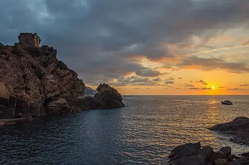
South of Calvi the D81 becomes a narrow, winding coast road with few places to pass. At Porto, red porphyry cliffs and a Genoese watchtower rise above a pebble bay, and in summer boats leave for the Scandola nature reserve, which can only be seen from the sea.
The road from Porto to Piana runs through the Calanques de Piana, pinnacles of red granite above the Gulf of Porto, on a stretch so narrow that motorhomes and coaches often have to reverse to pass each other. Drive it early in the morning and use the lay-bys to stop rather than halting on the road. Beyond Piana the road winds on to Ajaccio, Napoleon’s birthplace, with a lively market and harbour.
From Ajaccio the T40 runs south past Propriano and the granite town of Sartène to Bonifacio, whose old town sits on white limestone cliffs that hang over the sea. Walk the cliff path at sunset for the best view of the houses on the edge. Book ferries well ahead for July and August, and note that wild camping is not allowed in much of Corsica, so plan nights at campsites.
Which stops are on Corsica’s wild west coast?
In driving order. Distances are estimates between consecutive stops.
- 1Start
Bastia
France - 273 km
Calvi
France - 342 km
Porto and Scandola coast
NaturePorto, FranceRed porphyry cliffs and a Genoese watchtower above a pebble bay. Boats leave for the Scandola reserve in summer.
- 48 km
Calanques de Piana
ViewsPiana, FranceRed granite pinnacles above the Gulf of Porto, on a narrow, twisting coast road.
- 546 km
Ajaccio
France - 686 km
Bonifacio cliffs
ViewsBonifacio, FranceAn old town perched on white limestone cliffs that hang over the sea. Walk the cliff path at sunset.
How do you drive Corsica’s wild west coast in 5 days?
5 days, split by driving time. Campsites from OpenStreetMap: check opening dates before you go.
- Day 1: Bastia → Calvi · 73 km · 1 h 01 minOvernight nearby, for example: La Clé des Champs (1 km); Bella Vista (2 km).
- Day 2: Calvi → Porto and Scandola coast · 42 km · 0 h 35 minOvernight nearby, for example: Sole E Vista (1 km); Le Mandriale - Camping à la ferme (14 km).
- Day 3: Porto and Scandola coast → Calanques de Piana · 8 km · 0 h 06 minOvernight nearby, for example: Le Mandriale - Camping à la ferme (9 km); Sagone Resort (13 km).
- Day 4: Calanques de Piana → Ajaccio · 46 km · 0 h 38 minOvernight nearby, for example: U Prunelli (7 km); Camping Barbicaja (5 km).
- Day 5: Ajaccio → Bonifacio cliffs · 86 km · 1 h 11 minOvernight nearby, for example: Camping des Îles (5 km); Pertamina - U Farniente (4 km).
When is the best time for Corsica’s wild west coast?
The most pleasant months are usually April–June and September–October. Still fine, with some compromises, in March, July–August and November–December. July and August are the busiest months: book campsites early.
Estimate from long-term temperature averages, terrain and pass seasons
What should you know before driving Corsica’s wild west coast?
Tolls and vignettes for a car: about €18 (France).
- France: Motorway tolls. Tolls on most autoroutes; the limit drops to 110 km/h in rain. Motorway limit for cars: 130 km/h.
Road rules and fees change. Check official sources before you travel.
More routes for the best months
Practical guides for this route


Themes
Plan this route for your vehicle
Scout adapts this route to your vehicle, your days and your budget.
FAQs
How long is Corsica’s wild west coast?
5-day road trip of about 254 km (158 mi) with 6 stops, from Bastia to Bonifacio cliffs. About 3 h 31 min of driving in total.
How many days do you need for Corsica’s wild west coast?
We suggest 5 days: about 3 h 31 min of driving, which leaves time for the stops.
Where does Corsica’s wild west coast start and end?
It starts in Bastia and ends in Bonifacio cliffs.
Which countries does Corsica’s wild west coast pass through?
France.
Where can you camp along Corsica’s wild west coast?
OpenStreetMap lists 87 campsites and motorhome stopovers within 20 km of the stops on this route. For example: Camping San Damiano, U Sole Marinu and A Casaïola.
How much are the tolls on Corsica’s wild west coast?
Tolls and vignettes for a car: about €18 (France). Estimate with typical rates; motorhomes pay more, and vehicles over 3.5 t often pay by distance.