

Down the Guadalupe: maples, cypress and dance halls
A quieter Hill Country route following the Guadalupe River from a maple canyon past Kerrville and Comfort to the tubing towns of New Braunfels.
- Distance
- approx. 196 km (122 mi)
- Driving
- 2 h 11 min
- Suggested days
- 3
- Stops
- 7
- States
- TX
- Best time to go
- March–April and October–December
- Tolls and vignettes
- ≈ $1
- Updated
- May 22, 2026
At a glance: 3-day road trip of about 196 km (122 mi) with 7 stops, from Lost Maples State Natural Area to New Braunfels. About 2 h 11 min of driving in total. Best time to go: March–April and October–December. Tolls and vignettes for a car: about $1 (TX).
More road trips in Texas
Photos along the route


Route description
Begin at Lost Maples State Natural Area near Vanderpool, whose canyon hides bigtooth maples that turn red in late October and November; outside that season it is a quiet place to hike. Back roads then lead north to TX-39, which follows the upper Guadalupe past summer camps and cypress-lined swimming spots at Hunt.
At Ingram, stop for the Stonehenge II replica on the grounds of the arts center, then follow TX-27 into Kerrville, which has a riverside trail, big RV parks and every service. TX-27 continues to Comfort, a small town founded by German freethinkers with a well-kept historic center.
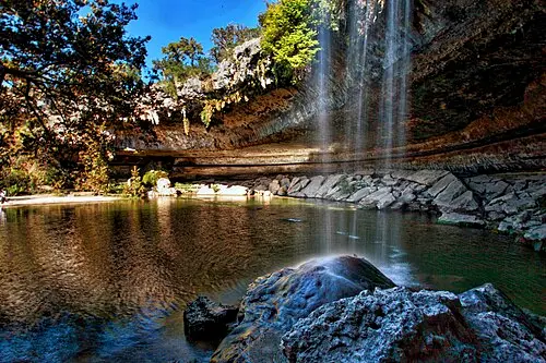
Continue east to Guadalupe River State Park, where the river runs under enormous bald cypress trees and past limestone bluffs. It is excellent for swimming and tubing, but summer weekends fill to capacity, so reserve ahead.
Finish in Gruene, now part of New Braunfels, for an evening at Gruene Hall, the oldest continuously operating dance hall in Texas. New Braunfels has many tube outfitters for the Comal and Guadalupe; outside summer the whole route is calm and pleasant for a motorhome.
Which stops are on Down the Guadalupe?
In driving order. Distances are estimates between consecutive stops.
- 1Start
Lost Maples State Natural Area
NatureVanderpool, TXA limestone canyon sheltering a relict stand of bigtooth maples that turn red and gold in autumn. Peak color usually falls in late October to mid-November; arrive early on weekends.
- 252 km
Stonehenge II
OdditiesIngram, TXA near-full-size replica of Stonehenge, plus two Easter Island heads, on the grounds of an arts center by the Guadalupe. Free to wander and a fun leg-stretch west of Kerrville.
- 312 km
Kerrville
TX - 429 km
Comfort
TX - 550 km
Guadalupe River State Park
NatureSpring Branch, TXSeveral miles of river frontage under huge bald cypress trees, with limestone bluffs, swimming and tubing. Summer weekends fill up; come on a weekday or reserve a day pass.
- 647 km
Gruene Historic District
HistoryNew Braunfels, TXA preserved German cotton-town center with Gruene Hall, the oldest continuously operating dance hall in Texas. Come in the evening for live music; parking is tight on weekends.
- 75 km
New Braunfels
TX
How do you drive Down the Guadalupe in 3 days?
3 days, split by driving time. Campsites from OpenStreetMap: check opening dates before you go.
- Day 1: Lost Maples State Natural Area → Kerrville · 40 mi · 0 h 43 minOn the way: Stonehenge II.Overnight nearby, for example: Comfort RV Resort (14 mi); Hill Country RV Park (4 mi).
- Day 2: Kerrville → Guadalupe River State Park · 49 mi · 0 h 53 minOn the way: Comfort.Overnight nearby, for example: Sound Ground (14 mi); Spring Branch RV Park (5 mi).
- Day 3: Guadalupe River State Park → New Braunfels · 33 mi · 0 h 35 minOn the way: Gruene Historic District.Overnight nearby, for example: Camp Huaco Springs (4 mi); Stone Creek RV Park (10 mi).
When is the best time for Down the Guadalupe?
The most pleasant months are usually March–April and October–December. Still fine, with some compromises, in January–February and May. Hot in June–September. July and August are the busiest months: book campsites early.
Estimate from long-term temperature averages, terrain and pass seasons
More routes for the best months
Practical guides for this route

 Photo by Malivez on Unsplash
Driving in the US: The Rules European Visitors Most Often Get Wrong at the Wheel

 Photo by Aleksandr Dalakian on Unsplash
Fuel, Tolls and Distances: Practical US Driving Math for Motorhome and Camper Travelers

 Photo by Tracy Zhang on Unsplash
US national parks: entry fees, passes and reservations in plain terms
Themes
Plan this route for your vehicle
Scout adapts this route to your vehicle, your days and your budget.
FAQs
How long is Down the Guadalupe: maples, cypress and dance halls?
3-day road trip of about 196 km (122 mi) with 7 stops, from Lost Maples State Natural Area to New Braunfels. About 2 h 11 min of driving in total.
How many days do you need for Down the Guadalupe: maples, cypress and dance halls?
We suggest 3 days: about 2 h 11 min of driving, which leaves time for the stops.
Where does Down the Guadalupe: maples, cypress and dance halls start and end?
It starts in Lost Maples State Natural Area and ends in New Braunfels.
Which states does Down the Guadalupe: maples, cypress and dance halls pass through?
Texas.
Where can you camp along Down the Guadalupe: maples, cypress and dance halls?
OpenStreetMap lists 98 campsites and motorhome stopovers within 19 mi of the stops on this route. For example: Comfort RV Resort, San Marcos River Retreat and Yogi Bear's Jellystone Park.
How much are the tolls on Down the Guadalupe?
Tolls and vignettes for a car: about $1 (TX). Estimate with typical rates; motorhomes pay more, and vehicles over 3.5 t often pay by distance.
More like this

 © Trey Perry · CC BY 3.0
Swimming holes and granite domes in the Texas Hill Country
 © Chris M Morris · CC BY 2.0
Spanish missions and the Frio River canyonlands

 © Larry D. Moore · CC BY 4.0