US 395: Eastern Sierra Scenic Byway
US 395 follows the eastern foot of the Sierra Nevada in California, from Lone Pine through Bishop and Mammoth Lakes to Mono Lake and Bridgeport. Many side roads close in winter.
- State
- California
- Length
- 557 mi (896 km) in California
- Top elevation
- Conway Summit, 8,138 ft (2,480 m)
- Start / end
- Lone Pine to Bridgeport (section described)
- Best season
- Late spring to fall; side roads close in winter
What should you know before visiting US 395: Eastern Sierra Scenic Byway?
No toll roads expected for a car.
- The high point is Conway Summit at 8,138 ft (2,480 m). Deadman Summit is close behind at roughly 8,040 ft.
- In winter, SR 120 to Tioga Pass, SR 108 over Sonora Pass and SR 89 over Monitor Pass are usually closed, as is SR 203 beyond Mammoth Mountain Inn toward Devils Postpile. Other side roads can close at any time.
- Outside developed campgrounds, the Inyo National Forest allows dispersed camping without services. Check fire restrictions and stay rules with the Forest Service first.
The drive
In California, US 395 runs from Hesperia to the Oregon line, about 557 miles in total. The Eastern Sierra section leads from Lone Pine, the gateway to Mount Whitney and Death Valley, through Independence, Big Pine and Bishop. Next come the turnoff to Mammoth Lakes (SR 203), Mono Lake near Lee Vining, the detour to Bodie (SR 270) and Bridgeport. Caltrans lists parts as a state scenic highway.
Camping
Outside developed sites, dispersed camping is possible in the Inyo National Forest: no water, toilets or other facilities, and Leave No Trace ethics apply. Forest Service campgrounds have maximum stays that vary by site. Fire restrictions are common in dry conditions. Check the current rules on stay length, campfires and access roads with the Inyo National Forest beforehand, since they change by year and location.
Planning
The highway is the main axis, but most highlights sit on side roads that close in winter. In spring or late fall, check road conditions with Caltrans first. Fuel and shops are mainly in towns such as Lone Pine, Bishop, Mammoth Lakes, Lee Vining and Bridgeport, with long open stretches between them. In a large motorhome, check access and turnaround options before taking side roads.
FAQs
How long is US 395 in California?
In California it is about 557 miles (896 km), from Hesperia to the Oregon line. The road leaves the state at Topaz Lake and runs about 87 miles through Nevada before re-entering California. The classic Eastern Sierra section is much shorter.
What closes in winter?
Usually closed: SR 120 (Tioga Pass), SR 108 (Sonora Pass), SR 89 (Monitor Pass) and SR 203 beyond Mammoth Mountain Inn toward Devils Postpile; SR 168 West at Aspendell also closes. Other side roads can close too. Caltrans reports current closures.
Can I camp freely with a motorhome?
Dispersed camping is possible in the Inyo National Forest outside campgrounds, without facilities. Other land has different rules. Check current rules and fire restrictions with the Forest Service.
Places to see
 © Tuxyso · CC BY-SA 3.0
Badwater Basin
At 282 feet below sea level, it is the lowest point in North America. The salt flats crack into hexagons.…
 © EF5 · CC0
Tunnel View, Yosemite
El Capitan, Bridalveil Fall and Half Dome in one frame. It is the first view of the valley when you arrive…
 © Christian David · CC BY-SA 4.0
Zabriskie Point
Golden badlands folded like cloth. Sunrise here is one of the classic desert views.
 Photo by Sebastian Frederik Jacobsen on Unsplash
General Sherman Tree
The largest living tree on Earth by volume, a giant sequoia in the Giant Forest.
 © Cullen328 · CC BY-SA 4.0
Empire Mine State Historic Park
One of California’s richest hard-rock gold mines, worked until 1956, with the owner’s stone cottage and…
 © Missvain · CC BY 4.0
Marshall Gold Discovery State Historic Park
The spot on the American River where James Marshall found gold in January 1848, starting the Gold Rush.…
 © King of Hearts · CC BY-SA 3.0
Mono Lake Tufa
Limestone towers that formed underwater and now stand along the shore of an ancient salt lake. Come at…
 © Tuxyso · CC BY-SA 3.0
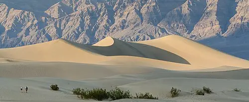
Mesquite Flat Sand Dunes
Rippled dunes you can walk into from the road. Avoid midday heat from May to September.