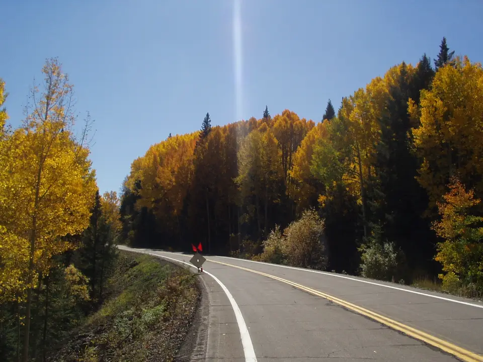
 📷 Unknown authorUnknown author or not provided, Public domain

Coronado Trail (US 191)
US 191 climbs from the desert at Clifton through the White Mountains to Springerville with about 460 curves. Services are scarce, so plan fuel and supplies before you start.
- State
- Arizona
- Length
- About 120 mi
- Top elevation
- About 9,260 ft
- Best season
- Late spring to fall
- Start / end
- Clifton – Springerville
What should you know before visiting Coronado Trail (US 191)?
No toll roads expected for a car.
- The route is about 120 miles and takes roughly three hours without long stops.
- There are no services between Morenci and Alpine, roughly 90 miles. Hannagan Meadow has a small seasonal lodge and is the only business on the way.
- A restriction for trucks over 40 ft is reported after Morenci because of sharp curves. Some stretches are signed 25 mph, and many have no guardrails.
- In winter the road is reportedly not plowed at night or on weekends. Check ADOT road conditions before driving in snow season.
The drive
The trail starts at Clifton, a high-desert town beside the Morenci open-pit copper mine, and ends at Springerville, with Alpine and Eagar near the northern end. The road gains height steadily through the Apache-Sitgreaves National Forest and reaches roughly 9,260 ft near KP Creek. Blue Vista, a picnic area at about 9,210 ft, is a natural stop. Expect tight bends, short straights and long stretches with no guardrail.
Planning
Fill the tank and water in Clifton, Morenci or Alpine. A road guide says the restriction for trucks over 40 feet applies past the Morenci mine entrance and is lifted at the Strayhorse Divide turnoff. Large motorhomes should ask ADOT or the Forest Service beforehand. Use low gear on descents. Cell coverage is often poor, so carry an offline map.
Camping
Camping and picnicking are possible along US 191 in the Apache-Sitgreaves National Forest, for example at Strayhorse Campground at about 7,780 ft. Forest campgrounds are often seasonal, so check opening and reservation rules with the Forest Service. Dispersed camping on national forest land is generally allowed under local rules, but fire restrictions can apply in dry months, so ask the ranger district. Nights at altitude can be cold even in summer.
FAQs
How long does the Coronado Trail take?
About three hours of driving for roughly 120 miles, based on ADOT. With photo stops, a picnic or a hike, plan half a day. Motorhomes are slower because of the 25 mph curves.
Where can I buy fuel on the Coronado Trail?
Fill up in Clifton or Morenci before starting and in Alpine afterwards. There are reportedly no services in between, a gap of roughly 90 miles. Hannagan Meadow has a seasonal lodge only.
Is the Coronado Trail open in winter?
It stays a public highway, but snow can close it. It is reportedly not plowed at night or on weekends. Check ADOT conditions and carry chains and supplies in snow season.
Places to see
 © Andrew Tree · CC BY 4.0
City of Rocks State Park
Tall volcanic rock pillars standing like a village in the grassland, with campsites tucked between them and…

 Photo by Alec Krum on Unsplash
Gila Cliff Dwellings National Monument
Stone rooms built by the Mogollon people in caves above a creek in the 1200s, reached on a one-mile loop…

 © CGP Grey · CC BY 2.0
Very Large Array
Twenty-seven giant radio telescope dishes lined up on the Plains of San Agustin. A visitor center and…

 © This illustration was made by Peter Potrowl. Please credit this with : © Peter Potrowl in the immediate vicinity of… · CC BY-SA 3.0
The Catwalk
A metal walkway bolted to the walls of narrow Whitewater Canyon, following the route of an old mining…
Campsites nearby
Trip guides
 Photo by Jerome Cha on Unsplash
Gila Wilderness: cliff dwellings, a catwalk and the Very Large Array
 © This illustration was made by Peter Potrowl. Please credit this with : © Peter Potrowl in the immediate vicinity of… · CC BY-SA 3.0