Las Alpujarras
The A-4132 runs about 42 km from Órgiva to Trevélez at the foot of the Sierra Nevada. The Junta de Andalucía has recognised it as a scenic road; it is winding and passes through white villages.
- Region
- Andalusia (Granada)
- Road
- A-4132
- Start / end
- Órgiva – Trevélez
- Top elevation
- Trevélez, 1,476 m
- Best season
- Spring and autumn
What should you know before visiting Las Alpujarras?
Tolls and vignettes for a car: about €8 (Spain).
- From Granada it is about 48 km to Lanjarón, the gateway to the Alpujarra. From there the road continues to Órgiva, where the A-4132 begins and climbs into the Alpujarra Alta.
- The A-4132 follows the foot of the Sierra Nevada and adapts to the ravines. The curves begin right after the turn-off, so expect slow driving and stops.
- Trevélez lies at 1,476 m. The municipality extends to the summit of Mulhacén (about 3,480 m), the highest point of the Iberian Peninsula.
- In Sierra Nevada National Park free camping without authorisation is banned, as is driving off the tracks. Do not overnight in or near river channels.
The drive
Beyond Lanjarón and Órgiva, the A-4132 leads through Soportújar into the Alpujarra Alta. A detour on the A-4129 reaches the villages of the Poqueira ravine: Pampaneira, Bubión and Capileira. Back on the A-4132 come Pitres, Pórtugos and Busquístar, then Trevélez. We found no verified vehicle length or height limits for the narrow village streets; with a large motorhome, check the map and signs beforehand.
Camping
Overnight rules depend on protection status. For Sierra Nevada National Park the Spanish environment ministry lists free camping without authorisation and driving off the tracks as banned. A motorhome area at Órgiva appears in directories. Some forest tracks lead to sights, but not all suit a motorhome. On site, follow signs and the municipality's notices.
FAQs
How long is the route?
The A-4132 from Órgiva to Trevélez is about 42 km long. Add the approach from Granada (about 48 km to Lanjarón) and detours such as the A-4129 to the Poqueira villages.
When is the best time to go?
Press reports name spring and autumn, when the ravines are green and snow still caps the peaks. Winter conditions can occur at altitude; check weather and road conditions before driving.
Is wild camping allowed in the Sierra Nevada?
Not without authorisation in the national park; the environment ministry lists free camping as banned. With a motorhome it is better to choose a campsite or motorhome area and clarify any exceptions beforehand.
Which villages lie along the route?
In order: Lanjarón, Órgiva, Soportújar, the Poqueira villages Pampaneira, Bubión and Capileira, then Pitres, Pórtugos, Busquístar and Trevélez. Capileira is a base for high-mountain routes.
How much are the tolls on Las Alpujarras?
Tolls and vignettes for a car: about €8 (Spain). Estimate with typical rates; motorhomes pay more, and vehicles over 3.5 t often pay by distance.
Places to see
 © Elliott Brown from Birmingham, United Kingdom · CC BY-SA 2.0
Puente Nuevo
An 18th-century bridge spanning a gorge nearly 100 m deep in the middle of town.

 © Alejandro alejandro_ · CC0
Alhambra
Moorish palaces and gardens above Granada. Tickets sell out weeks ahead, especially for the Nasrid Palaces.

 © Eduardo Milla · CC BY-SA 4.0
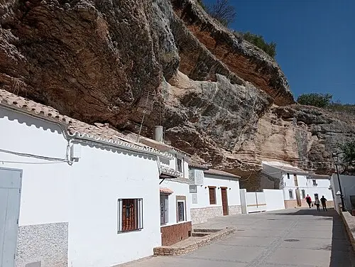
Setenil de las Bodegas
A white village whose houses are built under huge rock overhangs.

 © Matt Batchelor from Scott Township, Pennsylvania, USA · CC BY 2.0
Poqueira gorge villages
Three white villages with flat roofs and chimneys, stepped up a gorge in the Sierra Nevada.